|
Hands
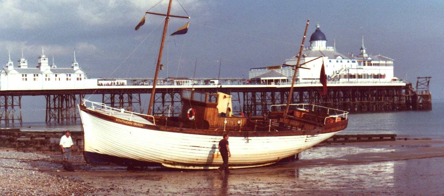
up who rode on the Southern Queen when it was operation. I did. The SQ was
completed in 1950. She was a seasonal sight, operating pleasure trips along the coast of Eastbourne to
Beachy
Head, first with her Sister the Eastbourne Queen then with the William Allchorn.
Both surviving boats are now rotting away. It is important that we save these beautiful craft for future
generations and time is
running out. The Southern Queen and the Eastbourne Queen were built in a barn at Westham Village not far from Pevensey Castle.
The barn was part of Street Farm of which no part remains today, though
local public houses display photos of the farm with the Queen in the foreground.
This is now a housing estate, much as Eastbourne’s very own Airport which played a
vital part in training pilots for the First World War - now an industrial estate
with a dual carriage way running through it. Do you know where it is. Did you even know
Eastbourne had an
Airport? It is interesting that the Southern Queen was taken almost two miles by road to her
launch site in Norman’s Bay. The Southern Queen is built of clinker construction and is one of the largest vessels of this type of construction to survive in the
UK, if not the world. She was licensed to carry seventy two passengers, is 46 feet in
length and weighs 27 tons. This form of construction is a dying art, as most boats of this size are made from
fibreglass. There is a project in the making to preserve this fine boat. If you
would like to get involved in any capacity, contact: Mr. Lloyd Stebbings C&G Dip
Mobile:- 07885 022436 Emails: pevenseymarine@aol.com
datelinemarine@aol.com

BLUE
GROWTH COLLABORATION JANUARY 2014
Following a presentation on Port Centricity at
Seawork 2013, stakeholders from the English and
French coastlines have met to discuss how collaboration and cooperation could ensure a sustainable future for the Channel.
The event, held in Rouen, marked the end of the four-year Channel Arc Manche Integrated Strategy (CAMIS) project which, together with 19 partner organisations, including the University of
Chichester, focused on supporting coastal communities bordering the Channel.
Dr David Cooper, a reader in management and economic development, University of Chichester, said at the event: “We have used the experience gained to undertake additional funded work on
analyzing the supply chains for the Sussex and Kent wind farms
and also to inform strategy development work for the Coast to Capital Local Enterprise Partnership.”
Alongside French colleagues, senior lecturer, Dr Dawn Robins, also from the University, presented her findings on the importance of small ports in supporting local communities, before her colleague Dr McKinley spoke about the role of marine clusters in sustainable growth of maritime businesses and coastal community regeneration.
The University has also produced a number of recommendations on best practice for port centric activity and developed a prototype online Channel Maritime Portal providing up-to-date information for Channel stakeholders and businesses.
The event was also an opportunity for partners to launch a new strategy which will be used to guide governance of the Channel for the future.
Called the Integrated Maritime Strategy (IMS), it aims to help stakeholders in the Channel region to work collaboratively to create a sustainable future. The IMS will guide future national and
EU policies, including supporting member states to meet objectives set by the Blue Growth Strategy, for future funding programmes to identify essential priorities for the Channel region.
The
most dangerous green lane route is between Dover and Calais
GEOGRAPHY
The English Channel (French: la Manche, Breton: Mor Breizh, Cornish: Mor Bretannek), often referred to simply as the Channel, is an arm of the Atlantic Ocean that separates southern England from northern France, and joins the North Sea to the
Atlantic. It is about 560 km (350 mi) long and varies in width from 240 km (150 mi) at its widest to 33.1 km (20.6 mi) in the Strait of Dover. It is the smallest of the shallow seas around the continental shelf of Europe, covering an area of some 75,000 km2 (29,000 sq mi).
The International Hydrographic Organization defines the limits of the English Channel as follows:
On the West. A line joining Isle Vierge (48°38′23″N 4°34′13″W) to Lands End (50°04′N 5°43′W).
On the East. The Southwestern limit of the North Sea.
The IHO defines the southwestern limit of the North Sea as "a line joining the Walde Lighthouse (France, 1°55'E) and Leathercoat Point (England, 51°10'N)". The Walde Lighthouse is 6 km east of Calais (50°59′06″N 1°55′00″E), and Leathercoat Point is at the north end of St Margaret's Bay, Kent (51°10′00″N 1°24′00″E).
The Strait of Dover (French: Pas de Calais), at the Channel's eastern end is its narrowest point, while its widest point lies between Lyme Bay and the Gulf of Saint Malo near its midpoint. It is relatively shallow, with an average depth of about 120 m (390 ft) at its widest part, reducing to a depth of about 45 m (148 ft) between Dover and Calais. From there eastwards the adjoining North Sea continues to shallow to about 26 m (85 ft) in the Broad Fourteens where it lies over the watershed of the former land bridge between East Anglia and the Low Countries. It reaches a maximum depth of 180 m (590 ft) in the submerged valley of Hurds Deep, 48 km (30 mi) west-northwest of Guernsey. The eastern region along the French coast between Cherbourg and the mouth of the Seine river at Le Havre is frequently referred to as the Bay of the Seine (French: Baie de Seine).
Three French river mouths. Top to bottom: the Somme, the Authie and the Canche
There are several major islands in the Channel, the most notable being the
Isle of Wight off the English coast, and the Channel Islands,
British Crown Dependencies off the coast of France. The Isles of Scilly off the far southwest coast of
England are not generally counted as being in the Channel. The coastline, particularly on the French shore, is deeply indented; several small islands close to the coastline, including Chausey and Mont Saint-Michel, are within French jurisdiction. The Cotentin Peninsula in
France juts out into the Channel, and the Isle of Wight creates a small parallel channel known as the Solent in English waters. The Celtic Sea is to the west of the Channel.
The Channel is of geologically recent origins, having been dry land for most of the Pleistocene period. It is thought to have been created between 450,000 and 180,000 years ago by two catastrophic glacial lake outburst floods caused by the breaching of the Weald–Artois anticline, a ridge that held back a large proglacial lake in the Doggerland region, now submerged under the North Sea. The flood would have lasted for several months, releasing as much as one million cubic metres of water per second. The cause of the breach is not known but may have been an earthquake or the build-up of water pressure in the lake. The flood carved a large bedrock-floored valley down the length of the Channel, leaving behind streamlined islands and longitudinal erosional grooves characteristic of catastrophic megaflood events. It destroyed the isthmus that connected Britain to continental Europe, although a land bridge across the southern North Sea would have existed intermittently at later times after periods of glaciation resulted in lower sea levels.
The Channel acts as a funnel that amplifies the tidal range from less than a metre as observed at sea to more than 6 metres as observed in the Channel Islands, the west coast of the Cotentin Peninsula and the north cost of Britanny. The time difference of about 6 hours between high water at the eastern and western limits of the Channel are indicative of the tidal range being amplified further by resonance.
For the UK Shipping Forecast the Channel is divided into the following areas, from the west:
* Plymouth
* Portland
* Wight
* Dover
LINKS
National Historic Ships UK
Park Row, Greenwich
London SE10 9NF
tel: 0208 312 8558
fax: 0208 312 6632
email: info@nationalhistoricships.org.uk
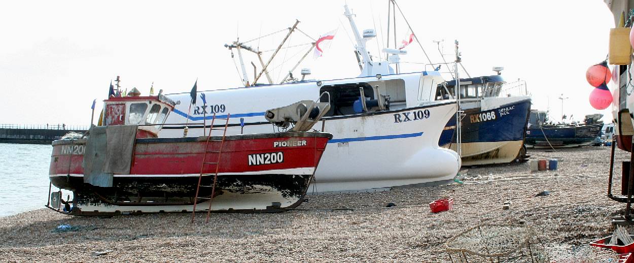
THE
STADE - Hastings in Sussex is home to the largest beach launched fishing
fleet in the world. For these hard working fishermen launching into
the English Channel and
recovery to the beach is an everyday function of the catch and a grueling
chore that we do not envy. The boats are especially adapted for hauling
across the abrasive pebbles with steel reinforced keels that keep the
boats upright when landed. Diesel powered tractors are used to push them
into the sea, and cable winches drag them back up the slope. If you enjoy
a traditional fish
and chips serving, this is a town you should visit.
ACIDIFICATION
- ADRIATIC - ARCTIC
- ATLANTIC - BALTIC
- BAY BENGAL - BERING
- CARIBBEAN - CORAL
- EAST CHINA
ENGLISH
CH - GOC
- GULF GUINEA - GULF
MEXICO - INDIAN -
IOC
- IRC
- MEDITERRANEAN - NORTH
SEA - PACIFIC - PERSIAN
GULF
RED
SEA - SEA JAPAN - STH
CHINA - PLASTIC
- PLANKTON - PLASTIC
OCEANS - SEA
LEVEL RISE - UNCLOS
- UNEP
WOC
- WWF
AMAZON
- BURIGANGA - CITARUM - CONGO -
CUYAHOGA - GANGES - IRTYSH -
JORDAN - LENA - MANTANZA-RIACHUELO
MARILAO
- MEKONG - MISSISSIPPI - NIGER -
NILE - PARANA - PASIG - SARNO - THAMES
- YANGTZE - YAMUNA - YELLOW

LINKS
& REFERENCE
http://www.channelswimmingassociation.com/
http://en.wikipedia.org/wiki/English_Channel
University-study-highlights-importance-of-cross-english-channel-collaboration
http://news.ninemsn.com.au/world/2013/07/23/06/08/divers-nearly-swallowed-by-humpback-whales http://www.cascadiaresearch.org/robin/humpback.htm http://www.seashepherd.org/lightbox_pages/humpback_whale.php
http://www.enchantedlearning.com/subjects/whales/species/Humpbackwhale.shtml
http://www.dimdex.com/en/warship-display.aspx http://www.npp.com.qa/ http://www.maritimeaustralia.com.au/ http://www.pacific2013.com.au/innovation-awards/index.html fansshare.com
sectasaur_antarctic_melt_john_storm_adventure_book_by_jameson_hunter
|