|
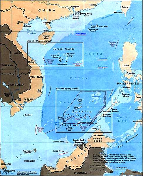
Map
of the
South China Sea
BEIJING
- JUNE 27 2015, REUTERS
Changing position on China's claims over the South China Sea would shame its ancestors, while not facing up to infringements of Chinese sovereignty there would shame its children, Foreign Minister Wang Yi said on Saturday.
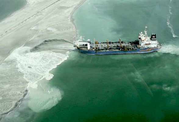
China has become increasingly assertive in the South China Sea, building artificial islands in areas over which the Philippines and other countries have rival claims, sparking alarm regionally and in Washington.
"One thousand years ago China was a large sea-faring nation. So of course China was the first country to discover, use and administer the Nansha Islands," Wang said, using the Chinese term for the Spratly Islands, which together with the Paracel Islands form the bulk of China's claims.
"China's demands of sovereignty over the Nansha Islands have not expanded and neither will they shrink. Otherwise we would not be able to face our forefathers and ancestors," the normally taciturn Wang said in unusually strong comments.
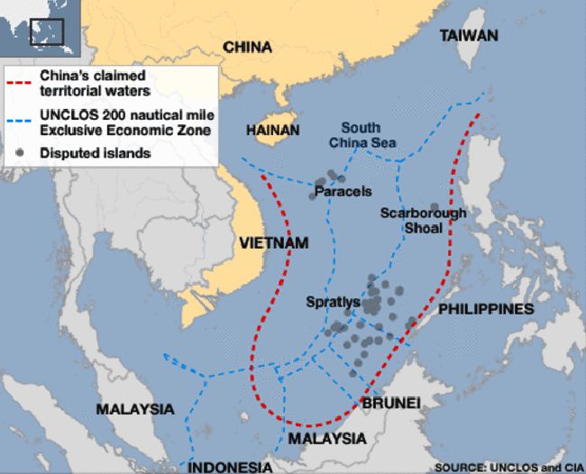
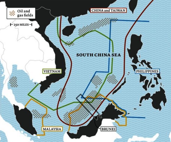
China claims most of the potentially energy-rich South China Sea, through which $5 trillion in ship-borne trade passes every year. The Philippines,
Vietnam, Malaysia, Brunei, and Taiwan also have overlapping claims.
Speaking to academics and former officials, Wang said China could not face its children and grandchildren if "the gradual and incremental invasion of China's sovereignty and encroachment on China's interests" was allowed to continue.
He said U.S. ships took Chinese troops to reclaim the Spratlys after they were occupied by Japan during World War Two. Other countries only started occupying what he said was Chinese territory from the 1960s after oil was discovered.
"China is in reality the biggest victim," Wang said.
On Friday, the U.S. State Department's number two diplomat compared China's behavior in pursuit of territory in the South China Sea to that of Russia in eastern Ukraine.
Wang did not address those comments, but defended China's land reclamation and building work in the South China Sea as necessary to improve living conditions, pointing out that other countries had been building there since the 1970s.
"It is only recently that China has started necessary development," he said.
CORAL REEFS - 19 JUNE 2015
China's construction on disputed reefs in the South China Sea will not destroy ocean ecology, the country's maritime regulator said, in the face of complaints from the Philippines that the work is damaging coral in the area.
Beijing's rapid reclamation around seven reefs in the Spratly archipelago has alarmed other claimants such as the Philippines and Vietnam and prompted growing criticism from the US government.
Manila in April said China's construction had destroyed about 300 acres (1.2 sq km) of coral reef and caused estimated annual losses of $100 million to coastal nations.
"The Nansha expansion project highly emphasises environmental protection," China's State Oceanic Administration said in a statement on its website late on Thursday, which was covered widely in Chinese media on Friday.
China refers to the Spratlys as the Nansha islands.
Numerous protection measures, including the use of a "new type" of dredging technique, had been implemented during planning and construction and had achieved good results, the administration said.
"Impact on coral reef ecology is localized, temporary, controllable and restorable," it said.
China claims most of the potentially energy-rich South China Sea, through which $5 trillion in ship-borne trade passes every year. The Philippines, Vietnam, Malaysia, Brunei and Taiwan also have overlapping claims.
China stepped up its creation of artificial islands last year, and there have been recent tensions between the Chinese navy and the U.S. military around the Spratlys.
Beijing said this week that some of its island construction work would be completed soon, but that it would continue to build facilities which it says will help with maritime search and rescue, disaster relief and environmental protection.
Washington has repeatedly asked China to halt its island building, fearing that a militarisation of the territorial disputes could threaten regional stability.
US
MILITARY WARNS OF CHINESE OUTPOSTS - APRIL 2015
According
to a Reuters report, the U.S. military commander for Asia warned that, China could eventually deploy
radar and missile systems on outposts it is building in the South China Sea that could be used to enforce an exclusion zone over the disputed
territory.
Admiral Samuel Locklear described as aggressive the land reclamation and construction projects China has been conducting at eight military outposts in the South China Sea. Locklear said the artificial islands planned by China will provide the nation with basing and resupply for its large fleet of maritime security vessels and the country would be able to deploy missiles and radar on the islands.
"It allows them to exert basically greater influence over what's now a contested area," the commander of US forces in the Pacific
is quoted as saying.
The building in the Spratleys included better berthing space for ships, as well as what was presumed to be an airfield on the Fiery Cross Reef, Locklear, head of the U.S. Pacific Command, said in testimony to the House Armed Services Committee.
It would allow China to deploy more patrol ships in the area and to base and resupply them, he said.
Locklear's area of command straddles a vast area of land and ocean where the
Obama administration has tried to elevate America's presence, and where other major powers jockey for influence. He was addressing a hearing on U.S. military strategy and posture in the region.
China drew condemnation from Japan and the United States when it imposed an Air Defense Identification Zone (ADIZ), in which aircraft are supposed to identify themselves to Chinese authorities, above the East China Sea in late 2013.
Meanwhile, the revised version of the US maritime strategy (A Cooperative Strategy for 21st Century Seapower - CS-21R), released last month, has been generating excitement in maritime
circles. It is especially valuable for clearly identifying Chinese assertiveness as a threat, for making existing strategy more relevant, and for providing specific ways to guide operational thinking in strategic scenarios.
The U.S. Office of Naval Intelligence (ONI) has just added sophisticated posters detailing Chinese ships and aircraft, equipment, and leadership structure, to its first unclassified report on China’s navy in six years.
ONI’s main document, “The PLA Navy: New Capabilities and Missions for the 21st Century,” already offers a cornucopia of new insights and highly vetted data points.
Two
maps
of the
South China Sea: south-north and north-south. Today, Vietnam is the only country in the region that seeks to impose serious limits on China’s maritime ambitions but does not have a defense agreement with the United States, making it an attractive target. On the other hand, even if it is scarcely more than one-30th of China’s size, Vietnam has a redoubtable martial culture, as the United States learned in the 1960s. The Chinese, too, should be familiar with the disposition toward resistance: Vietnam repelled a Chinese invasion of the country’s northern borderlands in 1979, leaving as many as 20,000 Chinese soldiers dead. Yet this incident has long since been censored out of China’s national consciousness. And just as they did at the beginning of that assiduously forgotten war, outlets of the Chinese state media have spoken recently of the need to give Vietnam “a lesson it deserves,” or to make it pay “an unaffordable price.”
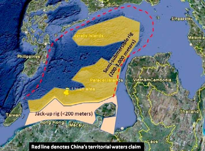
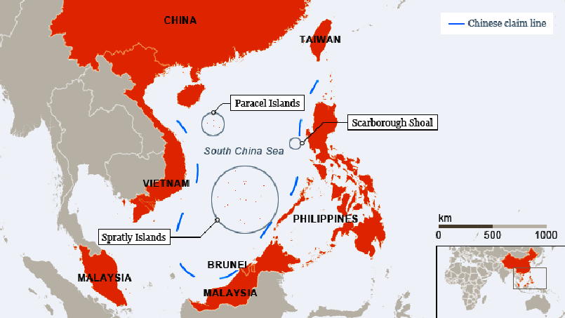
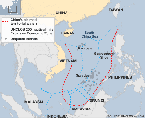
The South China Sea is home to many overlapping claims of maritime rights, as shown on the map above. Since 2009, China has asserted exclusive rights to more than 80 percent of the sea, enclosed by a line (in red) sometimes called the cow’s tongue. The line has no international standing.
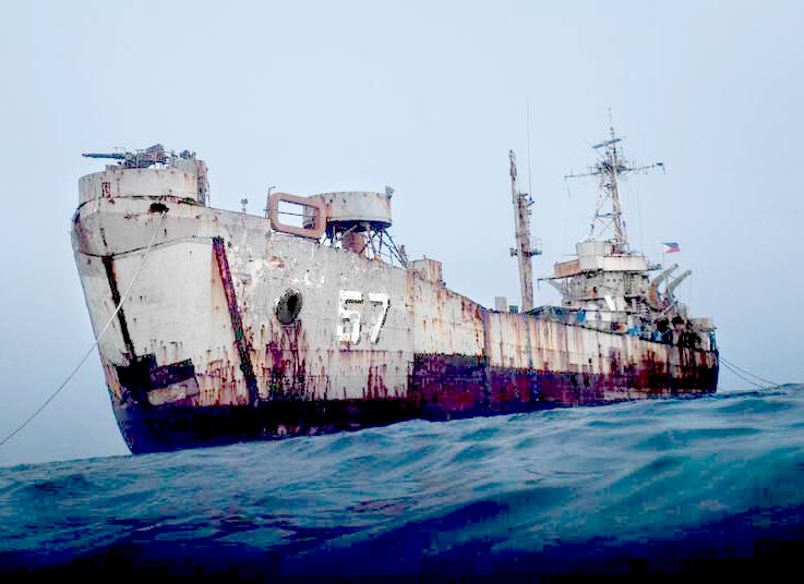
SIERRA
MADRE - Ayungin Shoal lies 105 nautical miles from the Philippines. There’s little to commend the spot, apart from its plentiful fish and safe harbor — except that Ayungin sits at the southwestern edge of an area called Reed Bank, which is rumored to contain vast reserves of oil and natural gas. And also that it is home to a World War II-era ship called the Sierra Madre, which the Philippine government ran aground on the reef in 1999 and has since maintained as a kind of post-apocalyptic military garrison, the small detachment of Filipino troops stationed there struggling to survive extreme mental and physical desolation. Of all places, the scorched shell of the Sierra Madre has become an unlikely battleground in a geopolitical struggle that will shape the future of the South China Sea and, to some extent, the rest of the world.
BBC
NEWS 7 May 2014 - VIETNAMESE AND CHINESE
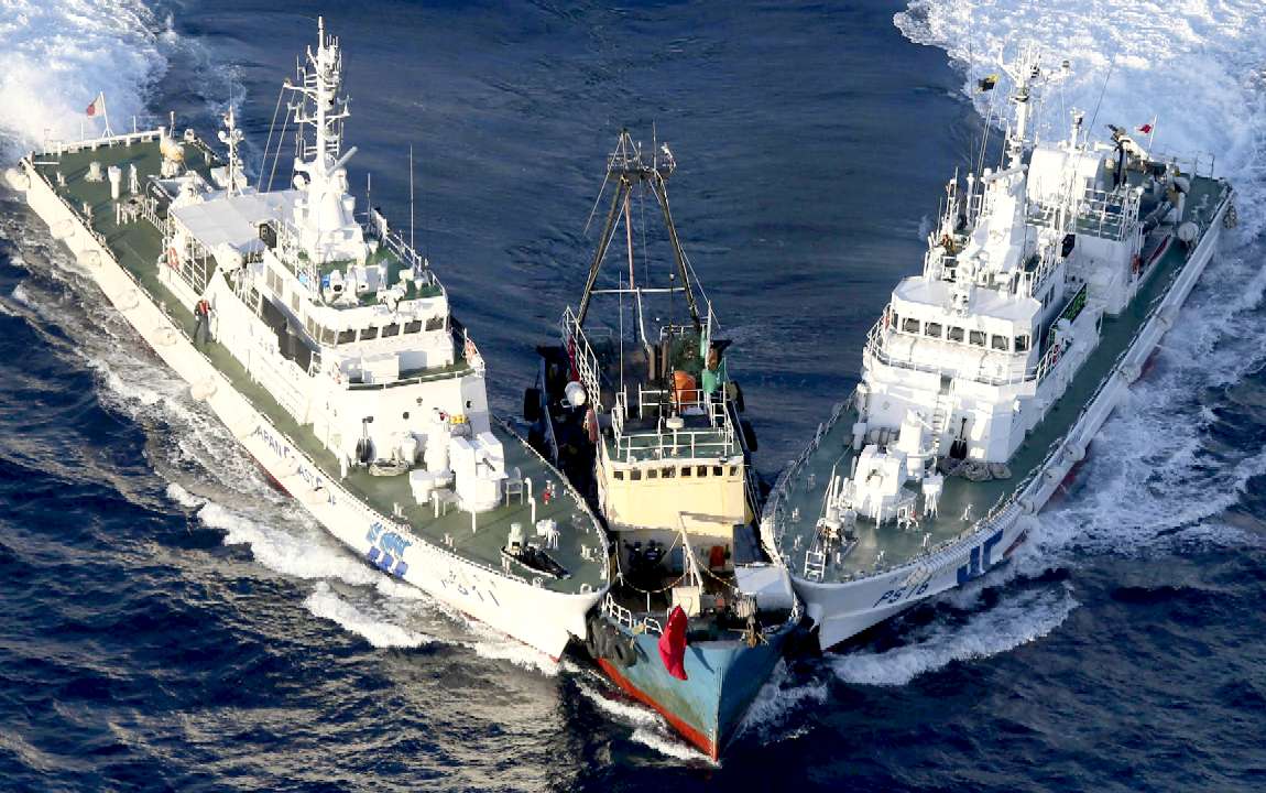
SHIPS COLLIDE IN SOUTH CHINA SEA
The incident happened as the Vietnamese navy was trying to prevent the Chinese from setting up an oil rig in an area claimed by both nations.
No shots were fired, reports say. But Vietnamese officials said that water cannons were used on their ships.
The incident is the most serious between the countries at sea in years, with dozens of boats now in the area.
Vietnamese officials said on Wednesday that the Chinese ships intentionally rammed their vessels.
Several sailors were injured, AP quoted one official as saying.
Vietnamese maritime police official Ngo Ngoc Thu told media in Hanoi on Wednesday that Chinese
boats had collided with Vietnamese vessels three times since 3 May.
Chinese officials said during a regular briefing on Wednesday that the oil rig was within China's territorial waters.
"The disruptive activities by the Vietnamese side are in violation of China's sovereign rights," Hua Chunying said.
The incident came as Philippine police seized a Chinese fishing boat and detained its 11 crew in another disputed part of the South
China Sea on Wednesday.
The boat carrying "large numbers of endangered species" was seized "to enforce maritime laws and to uphold Philippine sovereign rights", the Philippine foreign ministry said in a statement.
'ARMED MEN'
China's foreign ministry called the action provocative and demanded the immediate release of the
fishermen, who have been taken to a Philippine port.
The Chinese fishing boat was being towed to shore and charges would be brought against the crew members, a Philippine maritime official told Reuters news agency.
China's Xinhua state news agency said the fishing boat - named as Qiongqionghai 09063 - had been seized by an "unidentified armed vessel".
"Several armed men forced themselves on to the boat and fired four or five shots in the air. They then took control of the boat," Xinhua said.
China claims ownership of large parts of the South China Sea, including shoals and reefs, located off the coast of the Philippines.
Vietnam, the Philippines, Brunei,
Malaysia, China and
Taiwan all have competing claims in the region.
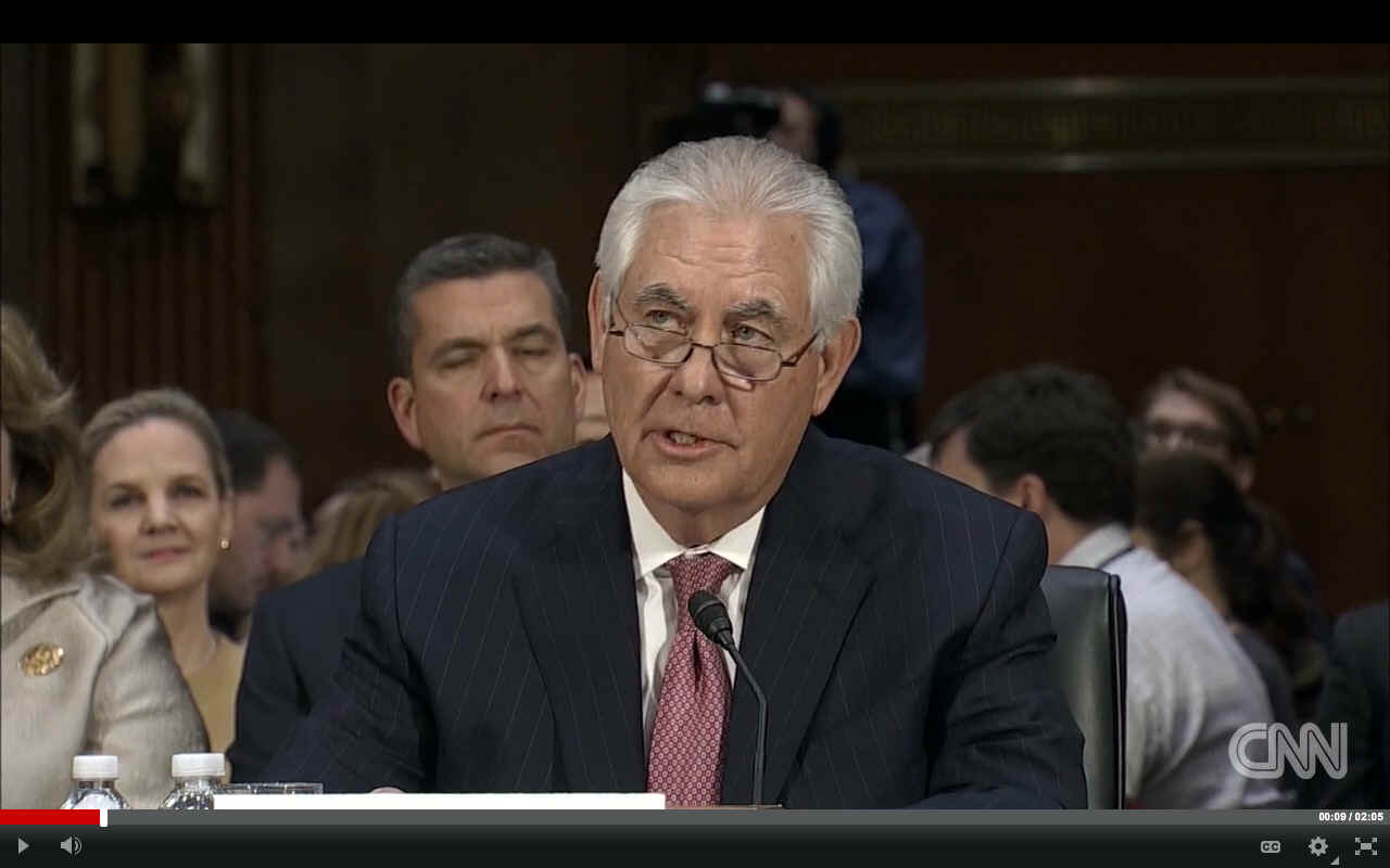
REX
TILLERSON - Hong Kong
(CNN) Chinese state media has taken aim at Rex Tillerson, President-elect Donald Trump's pick for secretary of state, after he suggested a more aggressive strategy toward Beijing in the contested waters of the South China Sea.
In his confirmation hearing Wednesday, Tillerson, the former CEO of oil giant
ExxonMobil, said that China should be denied access to the islands it has built.
The Global Times, a provocative but state-sanctioned tabloid, said that "unless Washington plans to wage a large-scale war in the South China Sea, any other approaches to prevent Chinese access to the islands will be foolish."
"Tillerson had better bone up on nuclear power strategies if he wants to force a big nuclear power to withdraw from its own territories," the unbylined opinion piece said on the paper's English-language site.
It concluded that Tillerson's statements were "far from professional."
"If Trump's diplomatic team shapes future Sino-US ties as it is doing now, the two sides had better prepare for a military clash."
The paper is published by the People's Daily -- the ruling Communist Party's mouthpiece. It's known for its hawkish and colorfully-worded editorials but analysts say it doesn't necessarily reflect Chinese policy.
The English-language China Daily took a similar stance but questioned whether Tillerson's views would translate into US foreign policy.
"Such remarks are not worth taking seriously because they are a mish-mash of naivety, shortsightedness, worn-out prejudices, and unrealistic political fantasies. Should he act on them in the real world, it would be disastrous," it said.
"What happened on Wednesday shows that if and when confirmed, Rex Tillerson needs to first acquaint himself with the ABCs of China-US relations and diplomacy at large."
LEGAL ACTION
China wants to establish an oil rig and start drilling soon in the area 120 miles (193km) from Vietnam's coast. This is the first time China has tried to explore the disputed waters between the two countries using its own rig and Vietnam does not want
China to set a precedent.
Hanoi is quoted as saying that: "it would do everything possible to protect its rights and does not rule out taking legal action against China at an international tribunal."
The US is quoted as calling China's plan "provocative" and urged restraint from both sides. But with dozens of ships from both sides confronting each other in the area, any careless move could ignite a bigger and potentially much more damaging conflict.
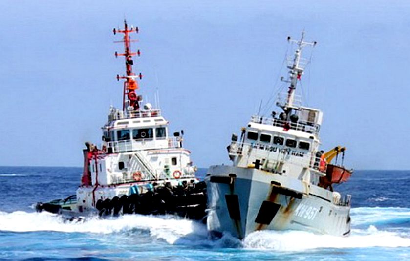
JUNE 2014 CLASHES
- China and Vietnam-owned vessels again clashed on Monday, June 23, near a Chinese oil rig that has been set up in a part of the South China Sea that is being claimed by both countries.
According to Vietnamese Coast Guard, the incident left two Vietnamese sailors injured and their Fisheries Surveillance ship KN-951 severely damaged.
Vietnam TV reports indicate that seven Chinese vessels pursued the Vietnamese vessel 11.5 nautical miles south-southwest before one of them rammed into it. Further reports say that two Chinese tugboats 284 and 285 and a maritime patrol ship No. 11 blocked the Vietnamese vessel steadying it on one side where tugboat named Xinhai 285 rammed into it, rendering serious damage on the ship.
On the other hand, Chinese Foreign Ministry Spokesperson Hua Chunying claimed at a news briefing the day after the incident that the Vietnamese vessel breached a Chinese security barrier and rammed a Chinese boat.
Since the oil rig was deployed on May 2, the two countries have had several similar incidents at the site where Vietnam claims territory saying the rig was within its 200-nautical-mile exclusive economic zone. China, however, declares that the China National Offshore Oil Corporation is simply carrying out normal activities on Chinese waters and is entitled to execute drilling there.

INNOVATION
& BLUE GROWTH
- Symposium, Qingdao, China, 28-30 October 2013 /
研讨会 “创新
& 蓝色发展”,
中国,青岛 2013年10月28-30日
The "Innovation and Blue Growth" symposium, which
was held in Qingdao in China from the 28th to the 30th of October 2013 was
one of the first international actions of the Maritime Innovative Territories International Network, MiTiN.
Organized by Qingdao (China) and Brest (France) with the support and contributions of the MiTiN network, the symposium will bring together experts from the scientific, economic, private and public sectors. Through scientific advice and the analyses of technical, economic and regulatory conditions, stakes and perspectives will be highlighted for a better understanding of the ocean and a better valorization of its resources, especially the biological ones.
Two topics were discussed in two sessions: oceanography and marine bio-resources. Advances in oceanography research can give a better knowledge of the complexity of the physical, chemical and biological processes that govern the marine environment. Fundamental knowledge of the ocean will open the way to sustainable exploitation of marine bio-resources for food, energy or health-related challenges.
Combining socio-economic development and environmental protection is the objective of sustainable development policies. Nowadays, “Blue Growth” is an international challenge in the maritime world.
The exploitation of marine resources (energy, minerals and food) is essential to global development, but such practices impact the marine environment, and more generally the climatic and biological balance of the planet.
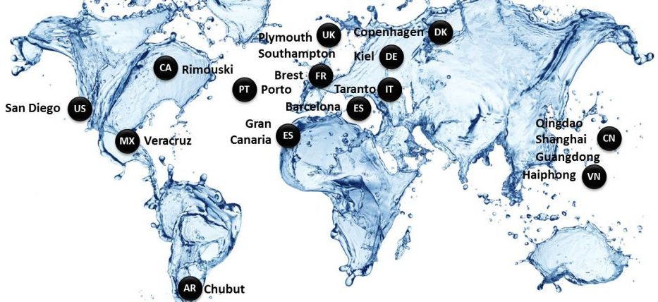
To find a balance between exploitation and preservation of the ocean is a very complex task. In July 2012, approximately twenty maritime regions involved in marine science and technology issues (Brest, Qingdao, San Diego, Kiel, Rimouski, Southampton, Porto…)
created the Maritime Innovative Territories International Network (MiTiN). By the signature of the "Convention for
Blue Growth", the MiTiN regions confirmed their support to a new and sustainable maritime economy.
GEOGRAPHY
The South China Sea is a marginal sea that is part of the Pacific Ocean, encompassing an area from the Singapore and Malacca Straits to the Strait of Taiwan of around 3,500,000 square
kilometres (1,400,000 sq mi). The area's importance largely results from one-third of the world's shipping transiting through its waters, and that it is believed to hold huge
oil and
gas reserves beneath its seabed.
It is located:
* south of mainland China, including the island of Taiwan in the east;
* west of the Philippines;
* east of the Malay peninsula and Sumatra, up to the Straits of Malacca in the west; and
* north of the Bangka–Belitung Islands and Borneo
The minute South China Sea Islands, collectively an archipelago, number in the hundreds. The sea and its mostly uninhabited islands are subject to competing claims of sovereignty by several countries. These claims are also reflected in the variety of names used for the islands and the sea.
The International Hydrographic Organization defines the limits of the South China Sea as follows:
On the South. The Eastern and Southern limits of Singapore and Malacca Straits [A line joining Tanjong Datok, the Southeast point of Johore (1°22′N 104°17′E) through Horsburgh Reef to Pulo Koko, the Northeastern extreme of Bintan Island (1°13.5′N 104°35′E). The Northeastern coast of Sumatra] as far West as Tanjong Kedabu (1°06′N 102°58′E) down the East coast of Sumatra to Lucipara Point (3°14′S 106°05′E) thence to Tanjong Nanka, the Southwest extremity of Banka Island, through this island to Tanjong Berikat the Eastern point (2°34′S 106°51′E), on to Tanjong Djemang (2°36′S 107°37′E) in Billiton, along the North coast of this island to Tanjong Boeroeng Mandi (2°46′S 108°16′E) and thence a line to Tanjong Sambar (3°00′S 110°19′E) the Southwest extreme of Borneo.
On the East. From Tanjong Sambar through the West coast of Borneo to Tanjong Sampanmangio, the North point, thence a line to West points of Balabac and Secam Reefs, on to the West point of Bancalan Island and to Cape Buliluyan, the Southwest point of Palawan, through this island to Cabuli Point, the Northern point thereof, thence to the Northwest point of Busuanga and to Cape Calavite in the island of Mindoro, to the Northwest point of Lubang Island and to Point Fuego (14°08'N) in Luzon Island, through this island to Cape Engano, the Northeast point of Luzon, along a line joining this cape with the East point of Balintang Island (20°N) and to the East point of Y'Ami Island (21°05'N) thence to Garan Bi, the Southern point of Taiwan (Formosa), through this island to Santyo (25°N) its North Eastern Point.
On the North. From Fuki Kaku the North point of Formosa to Kiushan Tao (Turnabout Island) on to the South point of Haitan Tao (25°25'N) and thence Westward on the parallel of 25°24' North to the coast of Fukien.
On the West. The Mainland, the Southern limit of the Gulf of Thailand and the East coast of the Malay Peninsula.
GEOLOGY
The sea lies above a drowned continental shelf; during recent ice ages global sea level was hundreds of metres lower, and Borneo was part of the Asian mainland.
The South China Sea opened after around 45 million years ago when Dangerous Ground were rifted away from southern China. Extension culminated in seafloor spreading around 30 million years ago, a process that propagated to the SW resulting in the V-shaped basin we see today. Extension ceased around 17 million years ago. Arguments have continued about the role of tectonic extrusion in forming the basin. Paul Tapponnier and colleagues have argued that as India collides with Asia it pushes Indochina to the SE. The relative shear between Indochina and China caused the South China Sea to open. This view is disputed by geologists who do not consider Indochina to have moved far relative to mainland Asia. Recent marine geophysical studies by Peter Clift has shown that the Red River Fault was active and causing basin formation at least by 37 million years ago in the NW South China Sea, consistent with extrusion playing a part in the formation of the sea. Since opening the South China Sea has been the repository of large sediment volumes delivered by the Mekong River, Red River and Pearl River. Several of these deltas are rich in oil and gas deposits.
RESOURCES
It is an extremely significant body of water in a geopolitical sense. It is the second most used sea lane in the world, while in terms of world annual merchant fleet tonnage, over 50% passes through the Strait of Malacca, the Sunda Strait, and the Lombok Strait. Over 1.6 million m³ (10 million barrels) of crude oil a day are shipped through the Strait of Malacca, where there are regular reports of piracy, but much less frequently than before the mid-20th century.
The region has proven oil reserves of around 1.2 km³ (7.7 billion barrels), with an estimate of 4.5 km³ (28 billion barrels) in total. Natural gas reserves are estimated to total around 7,500 km³ (266 trillion cubic feet). A 2013 report by the U.S. Energy Information Administration raised the total estimated oil reserves to 11 billion barrels. In 2014 China began to drill for
oil in waters disputed with
Vietnam.
According to studies made by the Department of Environment and Natural Resources, Philippines, this body of water holds one third of the entire world's marine biodiversity, thereby making it a very important area for the ecosystem. However the fish stocks in the area are depleted, and countries are using fishing bans as a means of asserting their sovereignty claims.
DISPUTES
BACKGROUND
The area may be rich in
oil and natural gas deposits; however, the estimates are highly varied. The Ministry of Geological Resources and Mining of the People's Republic of China estimate that the South China Sea may contain 17.7 billion tons of crude oil (compared to Kuwait with 13 billion tons). In the years following the announcement by the ministry, the claims regarding the South China Sea islands intensified. However, other sources claim that the proven reserve of oil in the South China Sea may only be 7.5 billion barrels, or about 1.1 billion tons. According to the US Energy Information Administration (EIA)'s profile of the South China Sea region, a US Geological Survey estimate puts the region's discovered and undiscovered oil reserves at 28 billion barrels, as opposed to a Chinese figure of 213 billion barrels. The same EIA report also points to the wide variety of natural gas resource estimations, ranging from 900 trillion cubic feet (25.5 trillion cubic meters) to 2 quadrillion cubic feet (56.6 trillion cubic meters), likely located in the contested Reed Bank".
The South China Sea is dubbed by China as the "second Persian Sea." The state-owned China Offshore Exploration Corp. planned to spend 200 billion RMB (US$30 billion) in the next 20 years to exploit oil in the region, with the estimated production of 25 million metric tons of crude oil and natural gas per annum, at a depth of 2000 meters within the next five years.
The Philippines began exploring the areas west of Palawan for oil in 1970. Exploration in the area began in Reed Bank/Tablemount. in 1976, gas was discovered following the drilling of a well. However, China's complaints halted the exploration.
On 27 March 1984, the first Philippine oil company discovered an oil field off Palawan, which is an island province bordering the South China Sea and the Sulu Sea. These oil fields supply 15% of annual oil consumption in the Philippines.
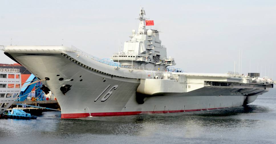
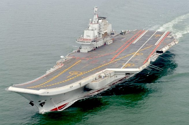
LIAONING
(16) - (Chinese:
中国人民解放军海军辽宁舰;
pinyin:
Zhōngguó Rénmín Jiěfàngjūn
Hǎijūn Liáoníng Jiàn), is the first aircraft
carrier commissioned into the People's
Liberation Army Navy Surface Force. She is classified as a training
ship, intended to allow the Navy to practice with carrier usage.
Originally
laid down as the Admiral
Kuznetsov class multirole aircraft carrier Riga for
the Soviet
Navy, she was launched on December 4, 1988, and renamed Varyag
in 1990. The stripped hulk was purchased in 1998 by the People's
Republic of China and towed to Dalian
Shipyard in north eastern China. After being completely rebuilt and
undergoing sea trials, the ship was commissioned into the PLAN as Liaoning
on September 25, 2012.
The nine-dotted line was originally an "eleven-dotted-line," first indicated by the then Kuomintang government of the Republic of China in 1947, for its claims to the South China Sea. After, the Communist Party of China took over mainland China and formed the People's Republic of China in 1949. The line was adopted and revised to nine as endorsed by Zhou Enlai.
The legacy of the nine-dotted line is viewed by some Chinese government officials, and by the Chinese military, as providing historical support for their claims to the South China Sea.
In the 1970s, however, the Philippines, Malaysia and other countries began referring to the Spratly Islands as included in their own territory. On 11 June 1978, President Ferdinand Marcos of the Philippines issued Presidential decree No. 1596, declaring the Spratly Islands (referred to therein as the Kalayaan Island Group) as Philippine territory.
The abundant fishing opportunities within the region are another motivation for the claim. In 1988, the South China Sea is believed to have accounted for 8% of world fishing catches, a figure that has grown since
then. There have been many clashes in the Philippines with foreign fishing vessels (including China) in disputed areas. China believes that the value in fishing and oil from the sea has risen to a trillion dollars.
The area is also one of the busiest shipping routes in the world. In the 1980s, at least 270 merchant ships used the
route each day. Currently, more than half the tonnage of oil transported by sea passes through it, a figure rising steadily with the growth of Chinese consumption of oil. This traffic is three times greater than that passing through the Suez Canal and five times more than the Panama Canal.
As of 1996, Vietnam, the Philippines, Brunei, Malaysia and other countries asserted claims within the Chinese nine-dotted
line. The United Nations Convention on the Law of the Sea, which came into effect on 16 November 1994, resulted in more intense territorial disputes between the parties.
As of 2012, all of the Paracel Islands are under Chinese control.
Eight of the Spratly Islands are under Chinese control; Vietnamese troops control the greatest number of Spratly islands, 29. Eight islands are controlled by the Philippines, five by Malaysia, two by Brunei and one by Taiwan. In 2012 the Indian Ambassador to Vietnam, while expressing concern over rising tension in the area, said that 50 per cent of its trade passes through the area and called for peaceful resolution of the disputes in accordance with international law.
|
|
|
BBC
map of disputed areas - South China Sea |
LINKS
& REFERENCE
BBC
world news asia
pacific south china sea The
Atlantic magazine archive 2014 November Chinas dangerous game Yahoo
China-says-changing-position-sea-dispute-shame-ancestors New
York Times 2013 October South China Sea John
Feffer Is-chinas-rise-still-peaceful Gma
Network
china-says-island-building-in-south-china-sea-won-t-destroy-ocean-ecology
Livemint
Politics India-Asean-to-discuss-South-China-Sea-dispute-at-Delhi-mee
Wikipedia
Territorial_disputes_in_the_South_China_Sea Wikipedia.org/wiki/Chinese_aircraft_carrier_Liaoning Asian
defence diplomacy http://www.mitin-network.org/Projets-1604-30-0-0.html http://www.asiandefence-diplomacy.com/blog/?m=20140701 http://www.theatlantic.com/magazine/archive/2014/11/chinas-dangerous-game/380789/ http://news.yahoo.com/china-says-changing-position-sea-dispute-shame-ancestors-080310808.html http://www.nytimes.com/newsgraphics/2013/10/27/south-china-sea/ http://www.johnfeffer.com/is-chinas-rise-still-peaceful/ http://www.gmanetwork.com/news/story/506998/news/nation/china-says-island-building-in-south-china-sea-won-t-destroy-ocean-ecology
http://www.livemint.com/Politics/j2x5cxz1gxYQwDPmK5NtuN/India-Asean-to-discuss-South-China-Sea-dispute-at-Delhi-mee.html
https://en.wikipedia.org/wiki/Territorial_disputes_in_the_South_China_Sea https://en.wikipedia.org/wiki/Chinese_aircraft_carrier_Liaoning
http://www.bbc.co.uk/news/world-asia-pacific-13748349
http://www.dimdex.com/en/warship-display.aspx http://www.marinelink.com/news/constructing-outposts389437.aspx http://www.npp.com.qa/ http://en.wikipedia.org/wiki/Qatar_Armed_Forces
http://www.asdwire.com/press-release-8988/ http://www.maritimeaustralia.com.au/ http://www.pacific2013.com.au/innovation-awards/index.html Maritime
Australia Limited Pacific
2013 Awards Fans
share Sectasaur Antarctic_melt_John_Storm_adventure_by_jameson_hunter

ACIDIFICATION
- ADRIATIC
- ARCTIC
- ATLANTIC - BALTIC
- BAY BENGAL - BERING
- BLACK - CARIBBEAN - CORAL - EAST
CHINA
SEA
ENGLISH CH
-
GOC - GULF
GUINEA - GULF
MEXICO
- INDIAN
-
IOC
-
IRC - MEDITERRANEAN -
NORTH SEA - PACIFIC
- PERSIAN GULF
RED
SEA - SEA
JAPAN - STH
CHINA - PLASTIC
- PLANKTON - PLASTIC
OCEANS - SEA
LEVEL RISE - UNCLOS
- UNEP
WOC
- WWF
AMAZON
- BURIGANGA - CITARUM - CONGO - CUYAHOGA
-
GANGES - IRTYSH
- JORDAN - LENA -
MANTANZA-RIACHUELO
MARILAO
- MEKONG - MISSISSIPPI - NIGER -
NILE - PARANA - PASIG - SARNO - THAMES
- YANGTZE - YAMUNA - YELLOW
|