|
HOW
CAN SATELLITES HELP US DETECT MARINE POLLUTION?
Generally,
litter is too small to be detected on satellite images. However, there are indirect factors that can be detected by means of remote sensing. Possible transport pathways of litter may be influenced by ocean currents which in turn can be detected with the use of satellite imagery.
Phytoplankton can form harmful algal blooms that can clearly be detected in the visbile bands of satellite images.
Chemicals spilt at sea can be toxic to both human and marine life. If the fraction of chemicals in the water is relatively large (e.g. following a
spill), they can be detected by means of remote sensing for example by using airborne laser sensors.
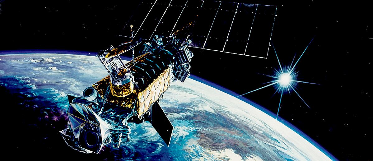
Ocean colour sensors are especially designed to accurately measure the visible (and near- infrared) light. Some of these sensors are mounted on
satellites.
These
are existing uses for satellites in space, but the challenge is to either
develop new sensors or to fine tune algorithms to find plastic, based on
information that is received from vehicles in the oceans the subject of
this research.
DETECTING MARINE POLLUTION
Typically, aircraft are used to fly over areas and scan for information.
There are though some advantages of satellites with respect to planes. One of them is the fact that extensive areas can be covered with their images and the same area can be observed systematically at every satellite pass; even
across national boundaries. It would be an expensive task for an aircraft to fly over an entire ocean to spot harmful substances. With a
satellite, the task is much
easier and could become economical in the sense of regenerating the oceans
for improved fish stocks and sustainable practices.
Another advantage is the homogeneity of the data: the quality of the data remains the same over the whole area observed.
Satellite images can thus provide a comprehensive picture of the overall extent of a pollution.
Making pollution visible
Remote sensors work by detecting either of these properties of the sea surface:
* colour
* reflectance
* temperature
* roughness
A pollutant can be detected on the water surface when it modifies one or more of these properties. Oil, for example, dampens surface waves and can therefore be detected as a 'lower roughness' signal in comparison to the sea water around it.
Satellites used to monitor marine pollution use synthetic aperture radars that generate microwaves in the 1mm to 1m range.
These systems see the reflective properties of the sea surface, useful for detecting the extent of
oil
slicks in the past.
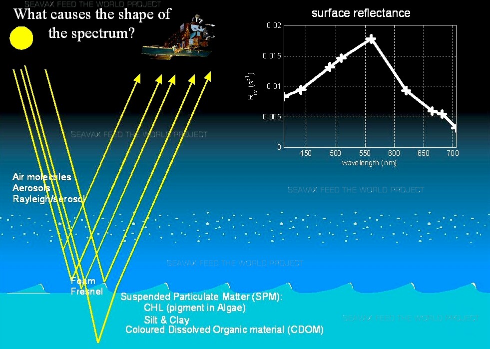
HOW
SENSORS WORK - Surface reflectance from the sea is captured and
interpreted by satellites in orbit around the earth.
ABOUT THE ESA
The European Space Agency
(ESA) is Europe’s gateway to space. Its mission is to shape the development of Europe’s space capability and ensure that investment in space continues to deliver benefits to the citizens of Europe and the world.
ESA is an international organisation with 22 Member States. By coordinating the financial and intellectual resources of its members, it can undertake programmes and activities far beyond the scope of any single European country.
What does ESA do?
ESA’s job is to draw up the European space programme and carry it through. ESA's programmes are designed to find out more about Earth, its immediate space environment, our Solar System and the Universe, as well as to develop satellite-based technologies and services, and to promote European industries. ESA also works closely with space organisations outside Europe.
Who belongs to ESA?
Austria, Belgium, Czech Republic, Denmark, Estonia, Finland, France, Germany, Greece, Hungary, Ireland, Italy, Luxembourg, the Netherlands, Norway, Poland, Portugal, Romania, Spain, Sweden, Switzerland and the United Kingdom. Slovenia is an Associate Member. Canada takes part in some projects under a cooperation agreement.
Bulgaria, Cyprus, Malta, Latvia, Lithuania and Slovakia have cooperation agreements with ESA. Discussions are under way with Croatia.
Where is ESA located?
ESA's headquarters are in Paris which is where policies and programmes are decided. ESA also has sites in a number of European countries, each of which has different responsibilities:
EAC, the European Astronauts Centre in Cologne, Germany;
ESAC, the European Space Astronomy Centre, in Villanueva de la Canada, Madrid, Spain;
ESOC, the European Space Operations Centre in Darmstadt, Germany;
ESRIN, the ESA centre for Earth Observation, in Frascati, near Rome, Italy;
ESTEC, the European Space Research and Technology Centre, Noordwijk, the Netherlands.
ECSAT, the European Centre for Space Applications and Telecommunications, Harwell, Oxfordshire, United Kingdom.
ESA Redu Centre, Belgium.
ESA also has liaison offices in Belgium, USA and Russia; a launch base in French Guiana and ground/tracking stations in various parts of the world.
How many people work for ESA?
There are around 2200 staff working for ESA, from all the Member States and include scientists, engineers, information technology specialists and administrative personnel.
Where do ESA’s funds come from?
ESA’s mandatory activities (space science programmes and the general budget) are funded by a financial contribution from all the Agency’s Member States, calculated in accordance with each country’s gross national product. In addition, ESA conducts a number of optional programmes. Each Member State decides in which optional programme they wish to participate and the amount they wish to contribute.
How big is ESA’s budget?
ESA's budget for 2012 is €4020 million. ESA operates on the basis of geographical return, i.e. it invests in each Member State, through industrial contracts for space programmes, an amount more or less equivalent to each country’s contribution.
How much does each European spend on ESA?
European per capita investment in space is very little. On average, every citizen of an ESA Member State pays, in taxes for expenditure on space, about the same as the price of a cinema ticket (in USA, investment in civilian space activities is almost four times as much).
How does ESA operate?
The Council is ESA's governing body and provides the basic policy guidelines within which ESA develops the European space programme. Each Member State is represented on the Council and has one vote, regardless of its size or financial contribution.
ESA is headed by a Director General who is elected by the Council every four years. Each individual research sector has its own Directorate and reports directly to the Director General. The present Director General of ESA is Jan Woerner.
ESA CONTACTS
Communication Department
European Space Agency
8-10 rue Mario Nikis
75738 Paris
Cedex 15
France
Tel: + 33 1 5369 7155
Fax: + 33 1 5369 7690
NASA
Even though remote sensing has proven to be a powerful tool, NASA has just 10 satellite missions in operation dedicated to ocean research. At least two of these missions may not continue beyond FY2003. Two new research satellites are expected to be launched by 2006. Some ocean remote-sensing research activities are actually conducted using data from sensors aboard operational satellites, including recent advances in the use of GPS signals to infer sea state and wind speed. A few research missions rely on international partnerships either for instrumentation or spacecraft platform. In addition, the United States relies on European satellites (ERS-1 and ERS-2); a Japanese satellite (JERS-1), and a Canadian satellite (RADARSAT-1) for Synthetic Aperture Radar data.
Operational Satellites: The National Academy of Science defined operational satellites as those that routinely and reliably generate services and products with specific accuracy, periodicity, and format, and that make their product available to a variety of users including public, private, and academic sectors. In the United States, NOAA has primary responsibility for operational satellites for ocean and coastal activities. DoD and USGS also have some ocean and coastal operational satellite capabilities.
To provide wider and more frequent data coverage of the ocean regions, scientists employ satellites that circle Earth above the atmosphere several times a day. Various satellites and measuring instruments provide the ocean surface data they use in their investigations.
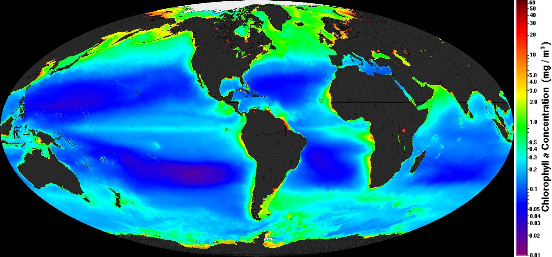
SATELLITE
- Map of Earth showing the chlorophyll concentrations in the ocean
currents.
NOAA - OCEAN OBSERVATIONS FOR CLIMATE MONITORING
With over three decades of satellite-based measurements and continued improvements to the quality and availability of these observations, satellites continue to fill a critical and unique role in the global ocean observing system for climate. Satellites, with their ability to make global observations on a frequent basis, provide a dimension to the ocean climate observing system that would be impractical or impossible to achieve with in situ platforms alone. These frequent, global observations are in many cases made at very fine spatial resolutions, enabling many new climate-ecosystem interaction studies as well as enhancing traditional climate science.
Making effective use of satellites as climate platforms requires overcoming several technical and scientific challenges. For example, numerous Advanced Very High Resolution Radiometers (AVHRRs) have flown on board the series of NOAA polar orbiting satellites for more than 20 years. Despite the similarities of the sensors, each behaves differently and each rides on a satellite whose characteristics differ from the others in the series. Adding to this challenge, both the instrument responses and the platform characteristics can and do change over time. Additionally, to detect typically small climate signals,
climate-quality algorithms must be developed iteratively, continually improving over operational, near real time algorithms. All of these challenges must be overcome if a credible, consistent record is to be generated.
In addition to the scientific and technical challenges, several organizational difficulties must also be resolved. Generating climate data records (CDRs), defined as a time series of sufficient length, consistency, and continuity to determine climate variability (NRC, 2004), requires a sustained, ongoing commitment to regularly reprocess the entire satellite time series using the latest available algorithms and techniques.Steps must be taken to insure guidance and feedback from the community is incorporated in the CDR generation process. To generate the best possible CDRs, data may be required from satellites operated by different agencies or countries requiring a high level of national and international coordination. This cooperation among nations is growing increasingly important to help mitigate the many potential observational gaps arising out of restructured satellite missions, the aging of the current constellation of ocean-observing satellites, and delays in launching new and replacement sensors. These and other organizational and institutional challenges must be met to insure optimal satellite contributions to the ocean observing system for climate.
In addition to meeting these challenges, environmental observations from satellites must always be viewed as fundamentally integrated with and dependent on in situ measurements if their value is to be fully realized. All satellite observations require in situ measurements in algorithm development, quality control, instrument characterization, and validation. Neither in situ nor satellite based observations can be relied on alone if a full understanding of the complex climate system is to be achieved. One example of the tight connection between in situ and satellite platforms is the Marine Optical Buoy (MOBY), which supports the in situ validation of satellite ocean color estimates from space.Another area where satellites and in situ measurements work together to observe climate change is the determination of sea level rise, where both satellite altimeters and in situ tide gauge networks are used. Satellite reprocessing efforts, which work to produce longer, more consistent and accurate data streams, rely heavily on large numbers of moored and drifting in situ buoys to calculate algorithm coefficients and conduct validation studies. In some areas, such as the determination of sea ice trends, gaps in the satellite record can only be filled by in situ observations of sea ice concentration. These examples and many more point to the need to maintain both satellite and in situ observing and reprocessing capabilities.
Satellite based observations of the oceans have already begun contributing to the climate observing system in many areas. Five of these areas are sea surface temperature (SST), ocean color, marine winds, sea surface topography, and sea ice. For each of these areas, a brief discussion of the importance of that parameter class to climate monitoring will be given along with a brief history and current status of the space-based sensors used to measure that parameter. Some example satellite products currently used will also be given along with a look forward into the future of measuring these parameters from space.

IN
ORBIT
- The global satellite observation system uses a number of platforms
THE GLOBAL SATELLITE OBSERVATION SYSTEM
Satellites are the primary means of obtaining global-scale observations (Fig. 2.4). They are grouped according to their orbiting patterns:
geostationary, which orbit at about 35,800 km above the equator and move at the velocity of the earth's rotation;
polar-orbiting, which orbit around the poles at approximately 850 km above the surface, and
research and development, which orbit between certain latitudes a few hundred km above the surface.
Operational satellites are dedicated to weather analysis and forecasting. Data are available in a timely manner for immediate use in hazard mitigation, commerce, security, and daily life. Emphasis is placed on ensuring that these services are not interrupted. Research satellite missions are dedicated to particular scientific goals, such as the measurement of ozone in order to document and understand climate change or the measurement of precipitation to better understand the global energy and water cycle. Many research satellites are designed to have a limited lifetime although some have lasted beyond the expected mission duration and some have been applied to operations. For example, the Tropical Rainfall Measurement Mission (TRMM) satellite data have been used extensively for monitoring hurricane intensity and position. With the growing recognition of the need for long-term climate analysis, operational data are being archived and used as climate data record.
Geostationary Satellites
Geostationary satellites sensors are most useful for tracking atmospheric features over great distances because of their high temporal resolution (15 - 30 minute intervals, or better) and hemispheric field of view (Fig. 2.5). However, the orbital distance of the satellites means that their spatial resolution is less than optimal for the identification of features smaller than 1 km.
Polar Orbiting Satellites
Polar-orbiting environmental satellites (POES) provide superior spatial resolution over a small field of view (on the order of 100 to 1000 km). For example, the NOAA POES carry the Advanced Very High Resolution Radiometer (AVHRR), which has 1-km resolution at six channels.
However, they view any given location at most twice per day. For the tropics, a single polar-orbiting satellite has many gaps in coverage during a given day (illustrated in the animation of Figure 2.6). With the proliferation of sequential polar-orbiting satellites, including the European Space Agency's MetOp, Joint Polar Satellite System (JPSS), and Global Precipitation Mission (GPM), we can expect more frequent observations of the tropics at high resolution.
Satellite sensors use either active or passive sensing techniques. Active sensors send signals toward the earth's surface and measure the signal return (like a radar). Passive sensors detect naturally occurring radiation. While passive sensors receive information from layers, active sensors have the advantage of measuring radiation from discrete levels and producing, for example, vertical precipitation and clouds profiles. Active sensors have higher spatial resolution than passive sensors.
HOW
CAN THIS HELP SEAVAX?
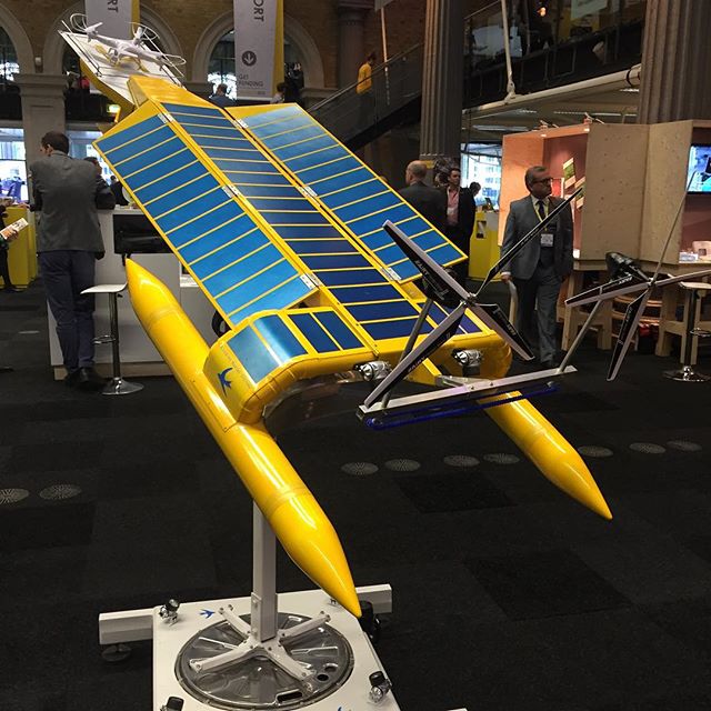
SeaVax
already uses satellite navigation via GPS as do most other modern ships.
But, where satellites are being used to monitor the oceans via the Copernicus
programme and other initiatives, they might be
tuned to search for plastic and direct SeaVax ships to
pollution hot
spots.
ACIDIFICATION
- ADRIATIC
- ARCTIC
- ATLANTIC - BALTIC
- BAY BENGAL - BERING
- CARIBBEAN - CORAL - EAST
CHINA
ENGLISH CH
-
GOC - GUANABARA
- GULF
GUINEA - GULF
MEXICO
- INDIAN
-
IRC - MEDITERRANEAN -
NORTH SEA - PACIFIC
- PERSIAN GULF - SEA
JAPAN
STH
CHINA - PLASTIC
- PLANKTON - PLASTIC
OCEANS - SEA
LEVEL RISE - UNCLOS
- UNEP
WOC
- WWF
AMAZON
- BURIGANGA - CITARUM - CONGO - CUYAHOGA
-
GANGES - IRTYSH
- JORDAN - LENA -
MANTANZA-RIACHUELO
MARILAO
- MEKONG - MISSISSIPPI - NIGER - NILE - PARANA - PASIG - SARNO - THAMES
- YANGTZE - YAMUNA - YELLOW


LINKS
& REFERENCE
http://www.iooc.us/ocean-observations/platforms/
http://oco.noaa.gov/resources/annual_program_reports/fy06_program_report/chapteriii.html
http://www.seos-project.eu/home.html
http://www.goes-r.gov/
http://ec.europa.eu/index_en.htm
http://www.copernicus.eu/ https://www.futurelearn.com/courses/oceans-from-space
SPACE
AGE -
Continuous monitoring of the oceans and constant plastic patrols is one
possible cure for pollution build up that is potentially decimating our
wild fish stocks,
for which the SeaVax ZCC (Zero Carbon Cruiser) platform is a robotic ocean
workhorse suited to satellite navigation and data sharing to enable more
effective plastic harvesting for blue
growth. The SeaVax concept is based on a stable
trimaran
hull design that is under development in the UK.
|