|
NOAA
SATELLITES SAVED 253 PEOPLE IN 2013
The same NOAA satellites that helped forecasters predict severe weather, such as the Moore, Okla., tornado last May and November’s deadly Midwest tornado outbreak, also played a key role in rescuing 253 people from potentially life-threatening scenarios throughout the United States and its surrounding waters last year.
A combination of NOAA polar-orbiting and geostationary satellites detected distress signals from emergency beacons carried by downed pilots, shipwrecked boaters and stranded hikers and relayed information about their location to first responders on the ground.
NOAA satellites are part of the international Search and Rescue Satellite Aided Tracking System, called COSPAS-SARSAT. This system uses a network of satellites to quickly detect and locate distress signals from emergency beacons onboard aircraft and boats, and from smaller, handheld personal locator beacons called PLBs.
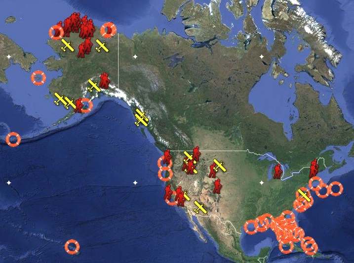
Of the 253 rescues, 139 were waterborne rescues, 34 were from aviation incidents and 80 were from events on land, where PLBs were used. Other rescue highlights from last year include:
*
Alaska had the most SARSAT rescues, with 101, followed by Florida, with 56;
* In Alaska, six passengers on a small plane were rescued after it crashed near mountainous terrain outside of Le
Conte Bay, Alaska;
* Four crewmen, ejected from a B-1 bomber before it crashed, were rescued in Broadus, Mont.; and
* A boater was rescued off the coast of Kitty Hawk, N.C., after he sustained a head injury.
“Each life we save underscores the undeniable value of NOAA satellites,” said Mary Kicza, assistant administrator for NOAA’s Satellite and Information Service.
When a NOAA satellite finds the location of a distress signal, the information is relayed to the SARSAT Mission Control Center based at NOAA’s Satellite Operations Facility in Suitland, Md. From there, the information is quickly sent to a Rescue Coordination Center, operated by either the U.S. Air Force for land rescues or the U.S. Coast Guard for water rescues.
Since 1982, COSPAS-SARSAT has been credited with supporting more than 35,000 rescues worldwide, including more than 7,250 in the United States and its surrounding waters.
By law, owners of emergency beacons are required to register them with NOAA at:
http://www.beaconregistration.noaa.gov
That registration information often helps provide better
and faster assistance to people in distress. It may also provide information about the location of the emergency, how many people need assistance, what type of help may be needed and other ways to contact the owner. At the end of 2013, NOAA’s registration database contained more than 400,000 registrations.
HYDROGRAPHIC
SURVEYS
While it may be hard to fathom, modern
fuel tankers that transport millions of gallons of
oil across the Arctic are sometimes forced to rely on ocean depth measurements reported by the explorer and mapmaker Captain James Cook back in 1778!
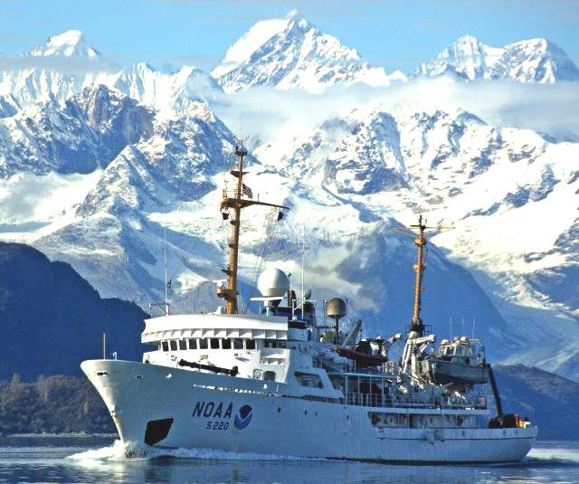
According to NOAA Corps Commander James Crocker, commanding officer of the NOAA Ship Fairweather, “Much of Alaska’s coastal area has never had full-bottom bathymetric surveys to measure water depths.” Fortunately, the Fairweather will leave its home port of Ketchikan,
Alaska, this week on a 30-day reconnaissance mission that will help NOAA prioritize its efforts to update navigational charts in the
Arctic.
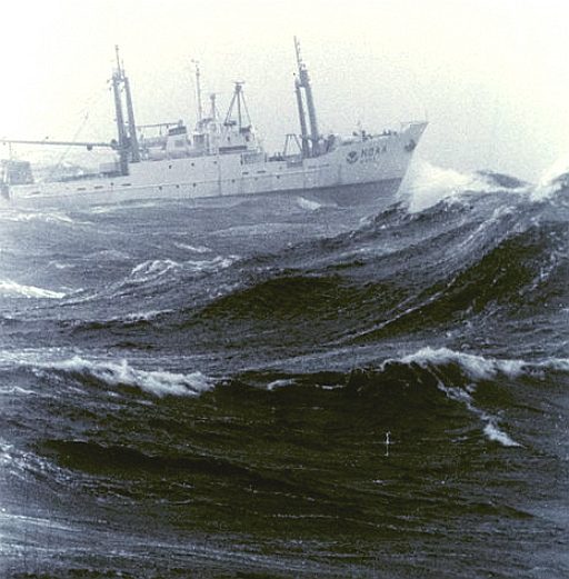
Crocker, who is also the chief scientist of this preliminary survey, explains that the Fairweather is setting out to check sparse soundings (a nautical term for depth measurements) along a busy maritime transit corridor from Dutch Harbor, Alaska, to the Canadian border. Commercial shippers, tankers, passenger vessels, and fishing fleets employ navigational charts produced by NOAA’s Office of Coast Survey to navigate the 1,500-nautical-mile route. Many of the charts, however, depict sporadic depth readings reported by private vessels in decades and, indeed, centuries past. Those vessels lacked precise positioning equipment and experts who knew how to take accurate measurements.
Plans, Priorities, and a Scientific Process
In June 2011, NOAA issued its Arctic Nautical Charting Plan, which outlines the agency’s efforts to update hydrographic data for the fairways, approaches, and ports along the Alaskan coast. With nearly 2,220 miles of low tidal shoreline in Alaska, the sheer size of the task demands a rigorous scientific process.
The Fairweather’s August voyage will help NOAA’s Office of Coast Survey set priorities for future full-coverage surveys. Tomorrow’s mariners, using modern charts created from precise data made possible with new technologies, will always celebrate
Captain Cook for his daring explorations. But they’ll rely on NOAA’s new start in surveying and charts for their safety.
The National Oceanic and Atmospheric Administration (NOAA; pronounced like "Noah") is a scientific agency within the United States Department of Commerce focused on the conditions of the oceans and the atmosphere. NOAA warns of dangerous weather, charts seas and skies, guides the use and protection of ocean and coastal resources, and conducts research to improve understanding and stewardship of the environment. In addition to its civilian employees, NOAA research and operations are supported by 300 uniformed service members who make up the NOAA Commissioned Officer Corps. The current acting Under Secretary of Commerce for Oceans and Atmosphere at the Department of Commerce and the agency's administrator is Kathryn Sullivan, who was nominated February 28, 2013.
ROLE
NOAA plays several specific roles in society, the benefits of which extend beyond the US economy and into the larger global community:
A Supplier of Environmental Information Products. NOAA supplies information to its customers and partners pertaining to the state of the oceans and the atmosphere. This is clearly manifest in the production of weather warnings and forecasts through the National Weather Service, but NOAA's information products extend to climate, ecosystems, and commerce as well.
A Provider of Environmental Stewardship Services. NOAA is also the steward of U.S. coastal and marine environments. In coordination with federal, state, local, tribal, and international authorities, NOAA manages the use of these environments, regulating fisheries and marine sanctuaries as well as protecting threatened and endangered marine species.
A Leader in Applied Scientific Research. NOAA is intended to be a source of accurate and objective scientific information in the four particular areas of national and global importance identified above: ecosystems, climate, weather and water, and commerce and transportation.
Recognizing that it is essential that we understand the challenges that we face as part of the Earth system in order to create appropriate solutions, NOAA conducts an end-to-end sequence of activities, beginning with scientific discovery and resulting in a number of critical environmental services and products. The five "fundamental activities" are:
* Monitoring and observing Earth systems with instruments and data collection networks.
* Understanding and describing Earth systems through research and analysis of that data.
* Assessing and predicting the changes of these systems over time.
* Engaging, advising, and informing the public and partner organizations with important information.
* Managing resources for the betterment of society, economy and environment.
HISTORY
NOAA was formed on October 3, 1970, after Richard Nixon proposed creating a new department to serve a national need "… for better protection of life and property from natural hazards … for a better understanding of the total environment … [and] for exploration and development leading to the intelligent use of our marine resources …" NOAA formed a conglomeration of several existing agencies that were among the oldest in the federal government. They were the
United States Coast and Geodetic Survey, formed in 1807; the Weather Bureau, formed in 1870—Geodetic Survey and Weather Service had been combined by a 1965 consolidation into the Environmental Science Services Administration (ESSA); and the Bureau of Commercial Fisheries, formed in 1871. NOAA was established within the Department of Commerce via the Reorganization Plan No. 4 of 1970. With its ties to the United States Coast and Geodetic Survey, NOAA celebrated 200 years of service in 2007. The organization's moniker is pronounced "Noah," recalling the name of the Biblical character who weathered The Great Flood.
NOAA works toward its mission through six major line offices, in addition to more than a dozen staff offices:
Line Offices
The National Environmental Satellite, Data and Information Service (NESDIS)
The National Marine Fisheries Service (NMFS)
The National Ocean Service (NOS)
The National Weather Service (NWS)
Office of Oceanic and Atmospheric Research (OAR)
Office of Program Planning and Integration (PPI)
Staff Offices
Office of the Federal Coordinator for Meteorology
Office of Marine and Aviation Operations
NOAA Central Library
NOAA Corps
NOAA research and operational activities are supported by a uniformed service, the NOAA Corps. They are a commissioned officer corps of men and women who operate NOAA ships and aircraft, and serve in scientific and administrative posts.

National Weather Service (NWS)
The National Weather Service (NWS) is tasked with providing "weather, hydrologic, and climate forecasts and warnings for the United States, its territories, adjacent waters and ocean areas, for the protection of life and property and the enhancement of the national economy." This is done through a collection of national and regional centers, and more than 120 local weather forecast offices (WFOs). They are charged with issuing weather forecasts, advisories, watches, and warnings on a daily basis. They issue more than 734,000 weather and 850,000 river forecasts, and more than 45,000 severe weather warnings annually. NOAA data is also relevant to the issues of global warming and ozone depletion. The NWS operates NEXRAD, a nationwide network of Doppler weather radars which can detect precipitation and their velocities. Many of their products are broadcast on NOAA Weather Radio, a network of radio transmitters that broadcasts weather forecasts, severe weather statements, watches and warnings 24 hours a day.
National Ocean Service (NOS)
The National Ocean Service (NOS) focuses on ensuring that ocean and coastal areas are safe, healthy, and productive. NOS scientists, natural resource managers, and specialists serve America by ensuring safe and efficient marine transportation, promoting innovative solutions to protect coastal communities, and conserving marine and coastal places.
National Environmental Satellite, Data, and Information Service (NESDIS)
The National Environmental Satellite, Data, and Information Service (NESDIS) was created by NOAA to operate and manage the United States environmental satellite programs, and manage the data gathered by the NWS and other government agencies and departments. Data collected by the
NWS, U.S. Navy, U.S. Air Force, the Federal Aviation Administration, and meteorological services around the world, are housed at the National Climatic Data Center in Asheville, North Carolina. NESDIS also operates the National Geophysical Data Center
(NGDC) in Boulder, Colorado, the National Oceanographic Data Center (NODC) in Silver Spring, Maryland, the National Snow and Ice Data Center
(NSIDC) and the National Coastal Data Development Center (NCDDC) which are used internationally by environmental scientists.
NESDIS also runs the:
* Office of Systems Development (OSD)
* Office of Satellite Operations (OSO)
* Office of Satellite Data Processing & Distribution (OSDPD)
* Satellite Applications and Research (STAR) formerly the Office of
Research & Applications
* Joint Polar Satellite System Program Office
* GOES-R Program Office
* International & Interagency Affairs Office
* Office of Space Commercialization
The service operates and manages many geosynchronous satellites and polar orbiting satellites. In 1960 TIROS-1, NOAA's first owned and operated geostationary satellite was launched. In 1983 NOAA assumed operational responsibility for LANDSAT satellite system. In 1984 the Tropical Ocean-Global Atmosphere program (TOGA) program began.
In 1977 the Pacific Marine Environmental Laboratory (PMEL) deployed the first successful moored equatorial current meter – the beginning of the Tropical Atmosphere/Ocean (TAO) array. In 1979 NOAA's first polar-orbiting environmental satellite was launched.
Current operational satellites include: NOAA-15, NOAA-16, NOAA-17, NOAA-18 and NOAA-19 (launched 2/6/2009).
National Marine Fisheries Service
(NMFS)
Fisheries, which was initiated in 1871 to protect, study, manage and restore fish. The NMFS has a marine fisheries research lab in Woods Hole, Massachusetts and is home to one of NOAA's five fisheries science centers.
Its law enforcement agency is the National Oceanic and Atmospheric Administration Fisheries Office for Law Enforcement based in Silver Spring, Maryland.
Office of Oceanic and Atmospheric Research (OAR)
NOAA's research, conducted through the Office of Oceanic and Atmospheric Research (OAR), is the driving force behind NOAA environmental products and services that protect life and property and promote economic growth. Research, conducted in OAR laboratories and by extramural programs, focuses on enhancing our understanding of environmental phenomena such as tornadoes, hurricanes, climate variability, solar flares, changes in the ozone, air pollution transport and
dispersion, El Niño/La Niña events, fisheries productivity, ocean currents, deep sea thermal vents, and coastal ecosystem health. NOAA research also develops innovative technologies and observing systems.
The NOAA Research network consists of 7 internal research laboratories, extramural research at 30 Sea Grant university and research programs, six undersea research centers, a research grants program through the Climate Program Office, and 13 cooperative institutes with academia. Through NOAA and its academic partners, thousands of scientists, engineers, technicians, and graduate students participate in furthering our knowledge of natural phenomena that affect the lives of us all.
The Air Resources Laboratory (ARL) is one of the laboratories in the Office of Oceanic and Atmospheric Research. It studies processes and develops models relating to climate and air quality, including the transport, dispersion, transformation and removal of pollutants from the ambient atmosphere. The emphasis of the ARL's work is on data interpretation, technology development and transfer. The specific goal of ARL research is to improve and eventually to institutionalize prediction of trends, dispersion of air pollutant plumes, air quality, atmospheric deposition, and related variables.
National Geodetic Survey (NGS)
The National Geodetic Survey is the primary surveying organization in the United States.
National
Integrated Drought Information System
NOAA is the lead federal agency for the National Integrated Drought Information System
(NIDIS).
Program Planning and Integration (PPI)
The Office of Program Planning and Integration was established in June 2002 as the focus for a new corporate management culture at
NOAA. PPI was created to address the needs to:
* Foster strategic management among NOAA Line and Staff Offices, Goal Teams, Programs, and Councils,
* Support planning activities through greater opportunities for active participation of employees, stakeholders, and
partners,
* Build decision support systems based on the goals and outcomes set in NOAA's strategic plan, and
* Guide managers and employees on program and performance management, the National Environmental Policy Act,
and socioeconomic analysis.
Intergovernmental Panel on Climate Change
Since 2001, the organization has hosted the senior staff and recent chair, Susan Solomon, of the Intergovernmental Panel on Climate Change's working group on climate science.

CONTACTS
National
Oceanic and Atmospheric Administration
1401 Constitution Avenue, NW
Room 5128
Washington, DC 20230
and
US Department of Commerce
National Oceanic and Atmospheric Administration
1305 East West Highway
Silver Spring, MD 20910
Organization
To
contact a specific NOAA organization, please visit NOAA
Organizations.
NOAA
Workforce Management Office / HR
For
questions related to human resource matters, including benefits, please
visit NOAA Workforce Management's contacts
page.
Employee
Directory
To
contact a NOAA employee, please visit the online NOAA
Staff Directory. For assistance, email the NOAA Staff Directory Help
Desk at NOAA.Staff.Directory@noaa.gov.
Publications
Requests
for formal and informal education resources may be directed to outreach@noaa.gov
or by calling (301) 713-1208.
Careers
For
information on careers with NOAA, please visit the NOAA
Careers Web site.
Media
Reporters
needing an interview or information should visit our Office
of Communications page.
Past
Weather
For
information on Past Weather, please visit the NOAA
Climatic Data Center Web site or call (828) 271-4800.
Nautical
Charts
Contact
the National Aeronautical Charting office at 1-800-638-8972.
Forecasts
via Phone by the National Weather Service
Contact
your local National Weather Service forecast office. Phone directory is
available at http://www.weather.gov/pa/recordedforecasts.php.
LINKS
http://www.omao.noaa.gov/
www.marinelink.com/news/satellites-helped-people
http://en.wikipedia.org/wiki/National_Oceanic_and_Atmospheric_Administration
US
Department of Navy Research, development & Acquisition - http://acquisition.navy.mil/ US
Fleet Forces Command - http://www.cffc.navy.mil/
US
http://www.msc.navy.mil/
http://www.airforce.com/
http://en.wikipedia.org/wiki/Naval_Oceanographic_Office
UKHO
http://www.maritimejournal.com/news101/industry-news/ukho-appoints-new-national-hydrographer http://en.wikipedia.org/wiki/United_Kingdom_Hydrographic_Office http://www.ths.org.uk http://www.spri.cam.ac.uk/friends/committee/ http://www.thefutureofnavigation.com/ten_steps.aspx http://www.quaynote.com/ankiti/www/?code=ecdis13&f=programme
Wiki
United_Kingdom_Hydrographic_Office
http://www.renewableenergyworld.com/can-the-military-meet-its-renewable-energy-goals-July24-2013 http://www.renewableenergyworld-events.com/register.html
The
key to accurate hydrographic mapping is continuous monitoring,
for which the Bluefish SNAV
platform, presently under development, is designed to be a robotic ocean workhorse. Based on a stable
SWASH
hull this design is under development in the UK, looking to expand into
the US and other maritime powers. This robot
ship uses no diesel fuel to monitor the oceans autonomously (COLREGS
compliant) at relatively high
speed 24/7 and 365 days a year - only possible with the revolutionary (patent) energy harvesting system. The
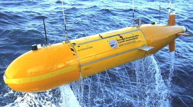
hullform is ideal for automatic release and recovery of ROVs
or towed arrays such as for the Autosub600, alternating between drone and fully autonomous modes.
If your company is interested in developing such a system please contact
us. This vessel
pays for itself in fuel saved every ten years.
|