|
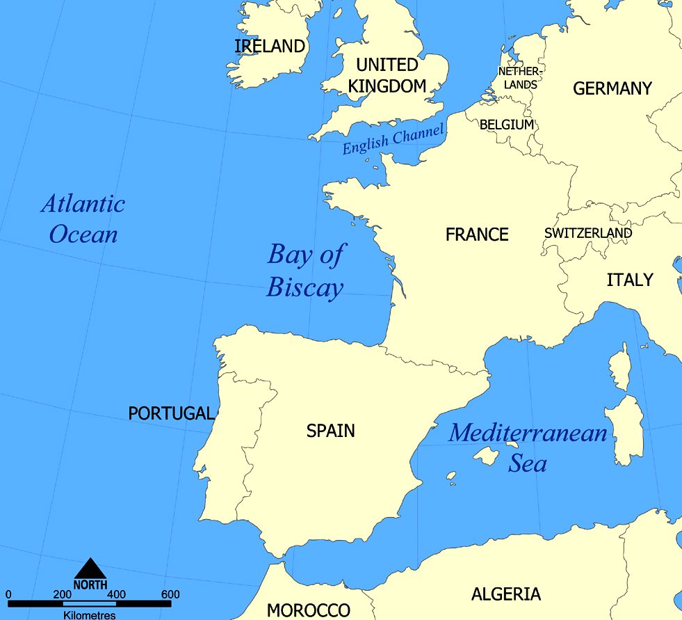
Map
of the Bay of Biscay
The Bay of Biscay
(Spanish: Golfo de Vizcaya, Basque: Bizkaiko Golkoa, French: Golfe de Gascogne) is a gulf of the northeast Atlantic Ocean located south of the Celtic Sea. It lies along the western coast of France from Point Penmarc'h to the Spanish border, and the northern coast of
Spain west to Cape Ortegal.
The average depth is 1,744 metres (5,722 ft) and the greatest depth is 4,735 metres (15,535 ft).
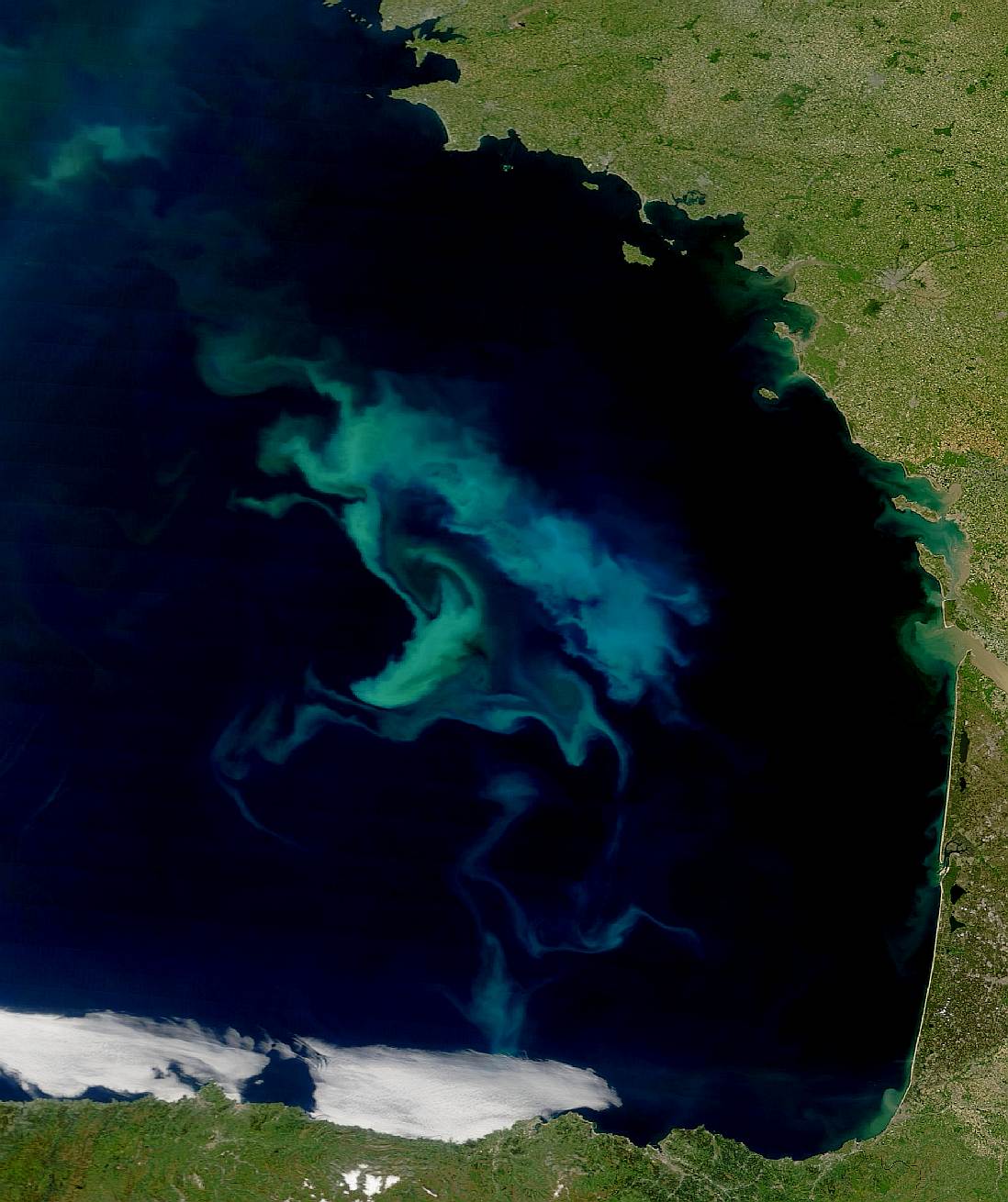
This
satellite photograph shows a phytoplankton bloom taking place in the Bay
of Biscay
CLIMATE
In late spring and early summer a large fog triangle fills the southwestern half of the bay, covering just a few kilometres inland.
This is a phenomenon known as June Gloom.
As winter begins, weather becomes severe. Depressions enter from the west very frequently and they either bounce north to the
British Isles or they enter the Ebro Valley, dry out, and are finally reborn in the form of powerful thunderstorms as they reach the
Mediterranean Sea. These depressions cause severe weather at sea and bring light though very constant rain to its shores (known as orballo, sirimiri, morrina, orbayu, orpin or calabobos). Sometimes powerful windstorms form if the pressure falls rapidly( Galernas), traveling along the Gulf Stream at great
speed, resembling a
hurricane, and finally crashing in this bay with their maximum power, such as the Klaus
storm.
The Gulf Stream enters the bay following the continental shelf's border anti-clockwise (the Rennell Current), keeping temperatures moderate all year long.

MARINE WILDLIFE
The car ferries from Gijón to Nantes/Saint-Nazaire, Portsmouth to Bilbao and from
Plymouth,
Portsmouth and Poole to Santander provide one of the most convenient ways to see cetaceans in European waters. Often specialist groups take the ferries to hear more information.
Volunteers and employees of Biscay Dolphin Research regularly observe and monitor cetacean activity from the bridge of the ships on the P&O Ferries Portsmouth to Bilbao route. Many species of whales and
dolphins can be seen in this area. Most importantly, it is one of the few places where the beaked whales, such as the Cuvier's beaked whale, have been observed relatively frequently. This is the best study area in the world for beaked whales.
North Atlantic Right
Whales, one of the most endangered whales, once came to the bay for feeding and probably for calving as well, but whaling activities by Basques and others almost wiped them out sometime prior to 1850s. In modern days, the eastern population of this species are considered to be almost extinct, and there has been no record of right
whales in the Bay of Biscay except for possible few sightings made in modern time, a pair which was possibly a mother-calf pair in 1977 at 43°00′N 10°30′W, and another pair in earlier June 1980 seen by merchantmen. Other records in the late 20th century include one off Galicia at 43°00′N 10°30′W in September 1977 reported by a
whaling company and another one seen off the Iberian Peninsula.
The best areas to see the larger cetaceans lie in the deep waters beyond the continental shelf, particularly over the Santander Canyon and Torrelavega Canyon in the south of the Bay.
The three-day round trip also gives sightings of good numbers of several species of seabirds, particularly gannets.
The alga Colpomenia peregrina was introduced and first noticed in 1906 by oyster
fishermen in the Bay of Biscay.
The Grammatostomias flagellibarba commonly known as the scaleless dragonfish are native to these waters.
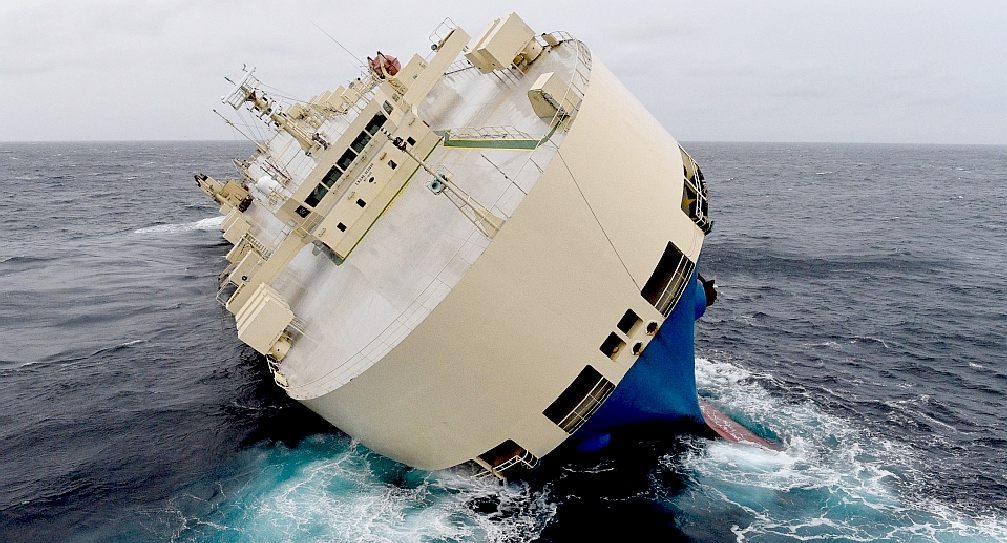
BBC NEWS FEBRUARY 1 2016
Efforts are under way to save a stricken cargo ship in the Bay of Biscay. Are modern ships still at risk from this notorious body of water, ask Claire Bates and Robert Spencer.
The Bay of Biscay, which is bounded by the west coast of France and the north coast of
Spain, covers an area of 86,000 sq miles. It's known for its rough seas and violent storms and much of this is thanks to its exposure to the
Atlantic ocean.
The latest victim is the car carrier Modern Express, which ran into trouble 230 miles south-west of Brest, France. Rescue efforts have been hampered by high seas and gale force winds, which are common in the bay.
"Winds blow from America to Europe and the waves grow all the way as they travel from west to east," says Prof Adrian New, from the
National Oceanography Centre.
"These swell waves can be felt in the Bay of Biscay if you're still in deep
water 100 miles out. They then become shorter choppier waves when you hit the continental shelf."
Swell waves are long sloping waves that are around 20ft high, but high winds can make them both bigger and steeper. Gales are most likely in the bay from October through March.
However, modern cargo carriers, like the Modern Express, are built to withstand these conditions. At 33,000 tons and 535ft long it's a mid-sized ship. It also contains 3,600 tonnes of
timber and digging machines, which would usually act as balancing weight.
"I don't think cargo ships are any more prone to going wrong [than other types of ships]," says Dr Chris Ware, from Greenwich University. "There's been one or two incidents in the last 18 months with this kind of vessel, but if they're properly laden they're probably as safe as any other vessel."
Some reports have suggested the Modern Express had lost power when it got into difficulty. "If you lose power your
ship will turn sideways on to the waves and then you're in serious trouble," New says. "It will roll around like a bucking bronco and water can come over the sides. Then if the cargo moves to one side the ship can start to list."
A ship can often right itself if it lists because of the heavy engines below the waterline. But shifting cargo can be a problem.
"She's floating on what looks like a very precarious angle," Ware says. "It's all to do with the centre of buoyancy and the centre of
gravity. I suspect something very heavy has shifted inside her and the vessel can't right herself - the weight is just in the wrong place."
LINKS
& REFERENCE
http://www.ctvnews.ca/world/capsized-cargo-ship-drifts-off-french-coast-in-rough-seas-1.2757272
http://www.bbc.co.uk/news/magazine-35461135
https://en.wikipedia.org/wiki/Bay_of_Biscay

ACIDIFICATION
- ADRIATIC - ARCTIC
- ATLANTIC - BALTIC
- BAY BENGAL - BERING
- CARIBBEAN - CORAL
- EAST CHINA SEA
ENGLISH
CH - GOC
- GULF GUINEA - GULF
MEXICO - HORMUZ - INDIAN -
IOC
- IRC
- MEDITERRANEAN - NORTH
SEA - PACIFIC - PERSIAN
GULF
RED
SEA - SEA JAPAN - STH
CHINA - PLASTIC
- PLANKTON - PLASTIC
OCEANS - SEA
LEVEL RISE - TAIWAN - UNCLOS
- UNEP
WOC
- WWF
AMAZON
- BURIGANGA - CITARUM - CONGO -
CUYAHOGA - GANGES - IRTYSH -
JORDAN - LENA - MANTANZA-RIACHUELO
MARILAO
- MEKONG - MISSISSIPPI - NIGER -
NILE - PARANA - PASIG - SARNO - THAMES
- YANGTZE - YAMUNA - YELLOW
|