|
|
SCOUT TRANSATLANTIC @ 30 DAYS
|
|
|
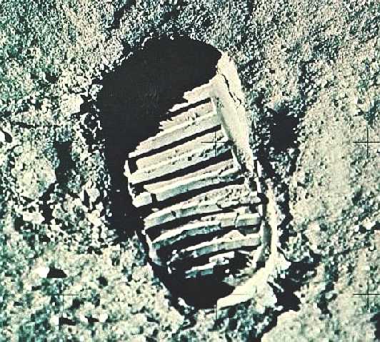
30 DAY UPDATE - HISTORY IN THE MAKING - That's it, 30 days and a historic milestone passed, with progress steady and the world record for an autonomous solar powered surface boat is secured convincingly - with more to come. The many local supporters of the team must be very proud of the achievement. It's no Moon shot, but all of the boating world will be very impressed at the accomplishment, and it is another leap for mankind.
A hugely expensive US mission that took man to the Moon using computers less powerful than the Arduinos used on the Scout
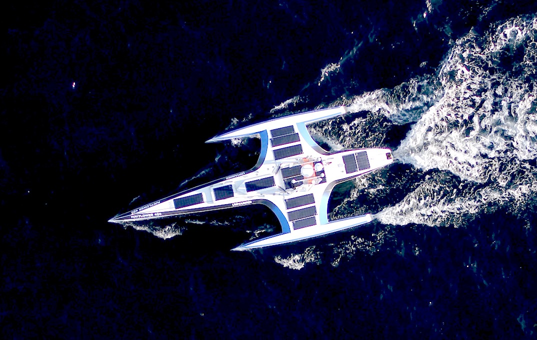
Following on from the Scout Atlantic bash in 2013, in 2020, a team comprising Promare, IBM, and many other technology partners, decided to attempt to cross the Atlantic against the prevailing winds and currents. They set out to build a 100ft craft named Mayflower Autonomous Ship (MAS) for launch and an attempt, aiming for the 400th anniversary of the Pilgrim Fathers journey starting on the 6th of September 1620.
They never made that date, partly due to Covid 19, but did manage to get a hull in the water for the ceremonies in Plymouth, Devon in 2020. On the 15th June 2021, the unmanned craft departed from Plymouth in England, aiming for Plymouth, Massachusetts, USA. You can follow the journey on their blog: https://mas400.com/dashboard
MAS 400 - The fully autonomous trimaran Setting off from Plymouth, England on the 15th June 2021. There are solar panels, that presumably add to the diesel-electric setup. The idea is to be COLREGs compliant with a self learning program, as such vessels build a database. Much the same as with the current bevy of self-driving robotaxis and robotracks. The question is therefore, will ships beat trucks to the autonomous punch?
RUNNING STATISTICS
Below are the latest figures for Scout. We will be reviewing these statistics regularly. As of the 20th September, Scout seems to having a bad time with average speed down. The good news is that she is still battling her way through and clocking up miles every hour. Scout is averaging 41. 6 miles a day [20-9-13], which is 1.73 mph. A fantastic achievement for the team.
10
SEPTEMBER 2013 STATISTICS: Distance
traveled by Scout 765.72 M Velocity
2.3 MI HR
11 SEPTEMBER 2013 STATISTICS Time
Elapsed: 18 DAYS: 04 HOURS: 51 MINUTES: 28 SECONDS Distance
traveled by Scout 756.84
Velocity 1 MI HR
12 SEPTEMBER 2013 STATS Time
Elapsed: 19 DAYS: 02 HOURS: 20 MINUTES: 09 SECONDS Distance
traveled by Scout 797.19 MI Velocity 1.6 MI HR
13 SEPTEMBER 2013 STATS Time
Elapsed: 20 DAYS: 04 HOURS: 14 MINUTES: 22 SECONDS Distance
traveled by Scout 854.39 MI
Velocity 1.4 MI HR
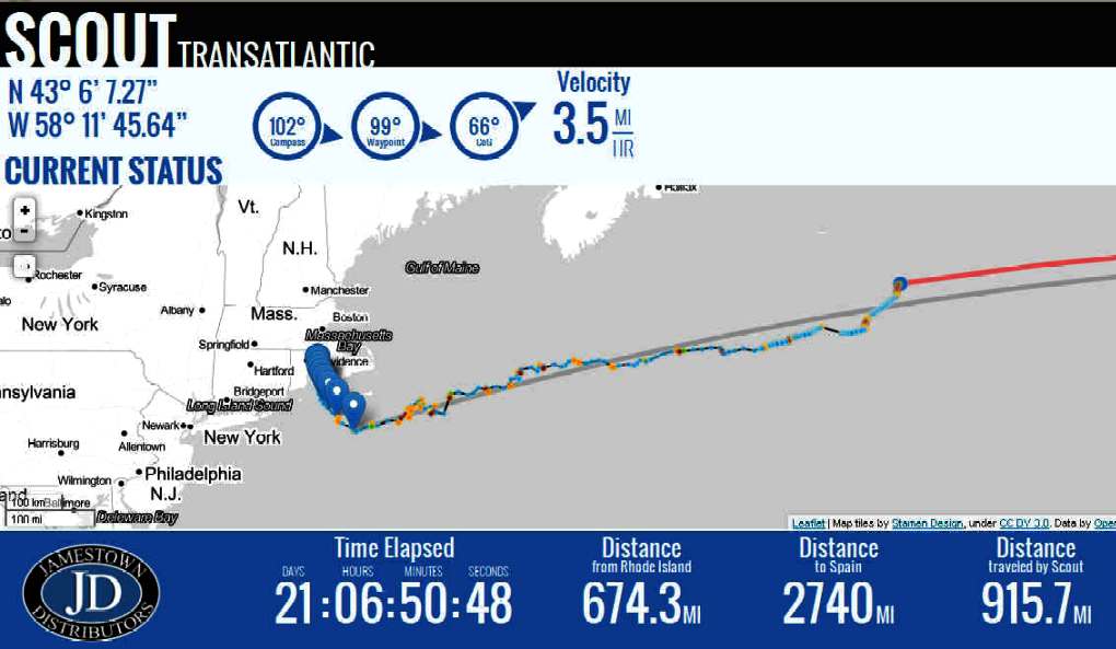
14 SEPTEMBER 2013 STATS Time Elapsed:
21 DAYS: 06 HOURS: 50 MINUTES: 17 SECONDS
Click on the image above to follow progress live
16
SEPTEMBER 2013 STATS
CURRENT STATUS: N 43° 24’ 7.13” W 57° 6’ 11.92” Compass 170° Waypoint 100° CoG 77°
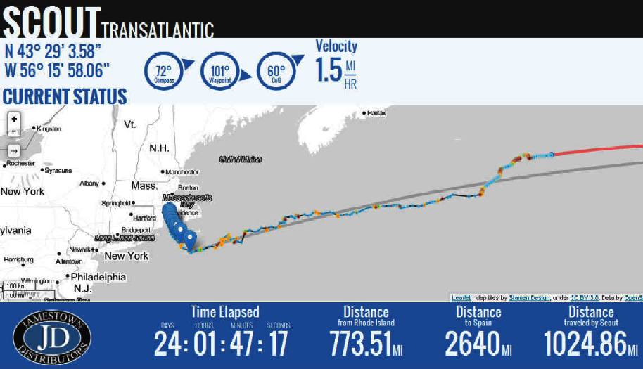
17 SEPTEMBER 2013 STATS Time Elapsed:
24 DAYS: 01 HOURS: 49 MINUTES: 47 SECONDS
CURRENT STATUS: N 43° 29’ 3.58” W 56° 15’ 58.06” Compass 72° Waypoint 101° CoG 60°
Click on the image above to follow progress live
18 SEPTEMBER 2013 STATS Time Elapsed:
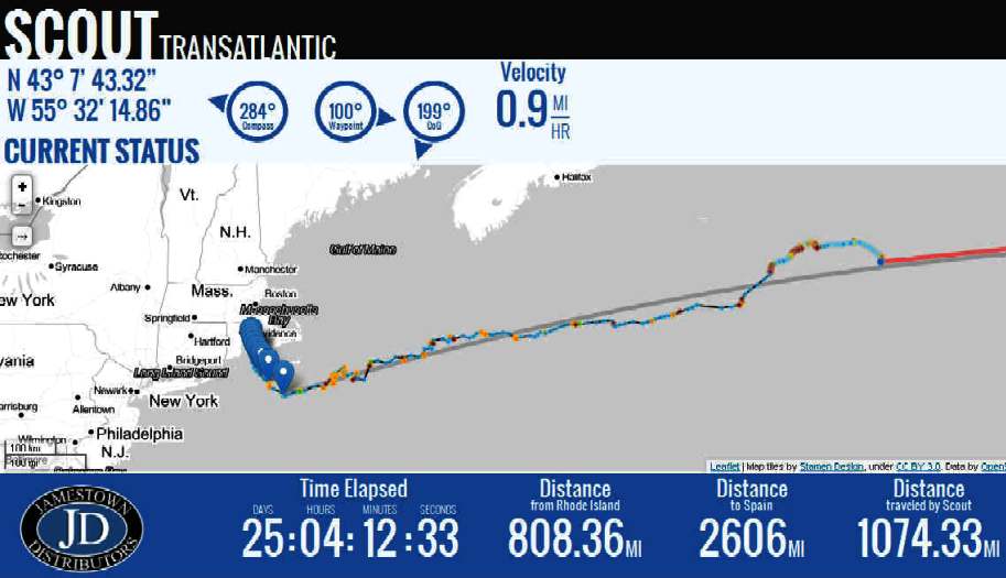
25 DAYS: 04 HOURS: 12 MINUTES: 33 SECONDS
CURRENT STATUS: N 43° 7’ 43.32” W 55° 32’ 14.86” Compass 284° Waypoint 100° CoG 199°
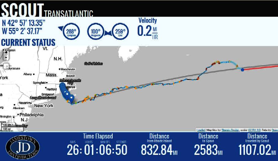
19 SEPTEMBER 2013 STATS Time Elapsed: 26 DAYS: 01 HOURS: 15 MINUTES: 33 SECONDS
CURRENT STATUS: N 42° 57’ 13.35” W 55° 2’ 37.17” Compass 288° Waypoint 100° CoG 259°
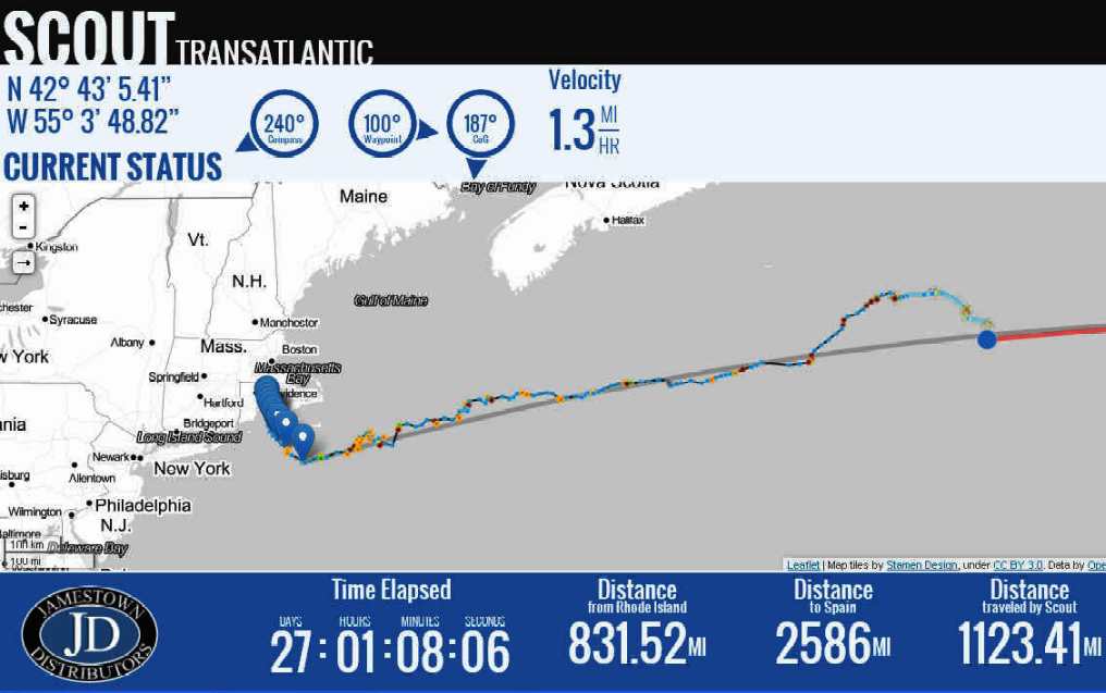
20 SEPTEMBER 2013 STATS Time Elapsed:
27 DAYS: 01 HOURS: 08 MINUTES: 06 SECONDS Distance traveled by Scout 1123.41 Velocity 1.3 MI HR
CURRENT STATUS: N 42° 43’ 5.41” W 55° 3’ 48.82” Compass 240° Waypoint 100° CoG 187°
Click on the image above to follow progress live
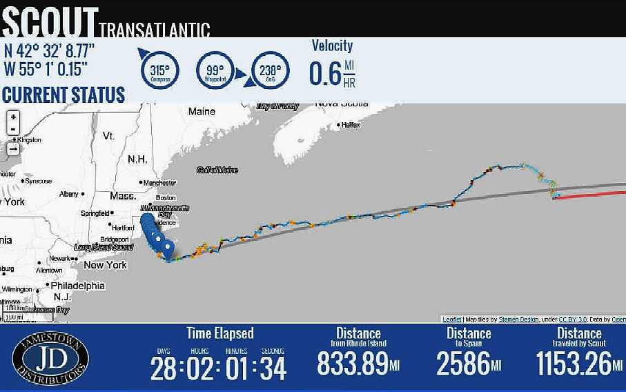
21 SEPTEMBER 2013 STATS Time Elapsed:
28 DAYS: 02 HOURS: 02 MINUTES: 34 SECONDS Distance
traveled by Scout 1153.26 Velocity 0.6
MI HR Velocity 0.6 MI HR
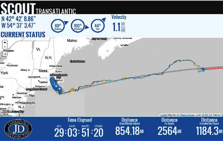
22 SEPTEMBER 2013 STATS Time Elapsed: 29 DAYS: 03 HOURS: 51 MINUTES: 20 SECONDS Distance from Rhode Island 854.18 MI Distance to Spain 2564 MI Distance
traveled by Scout 1184.3 Velocity
1.1 MI HR
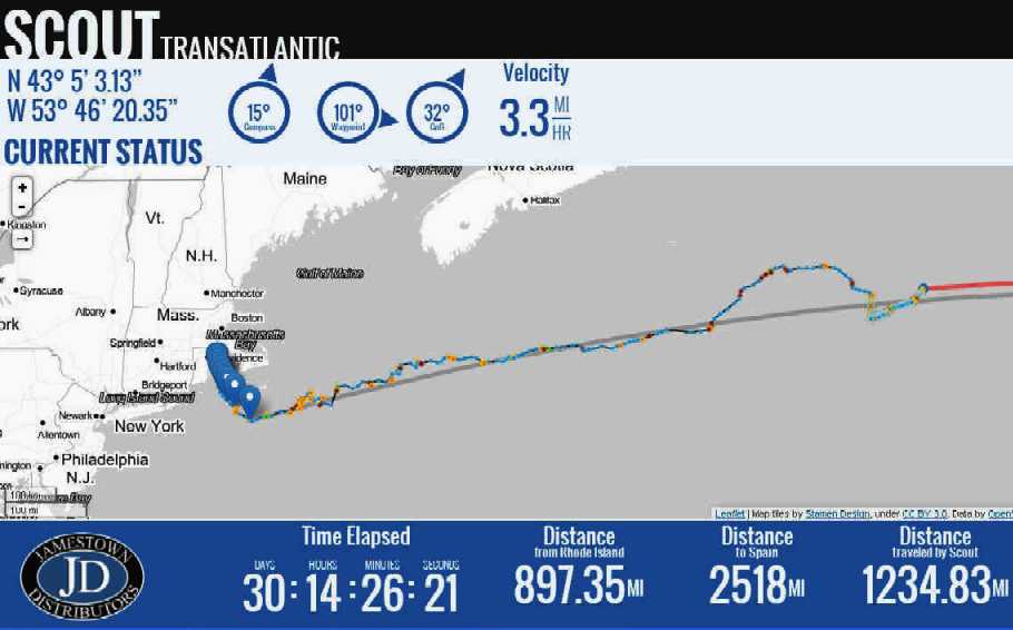
23 SEPTEMBER 2013 STATS Time Elapsed:
30 DAYS: 14 HOURS: 26 MINUTES: 34 SECONDS Distance
traveled by Scout 1234.83 Velocity 3.3 MI HR
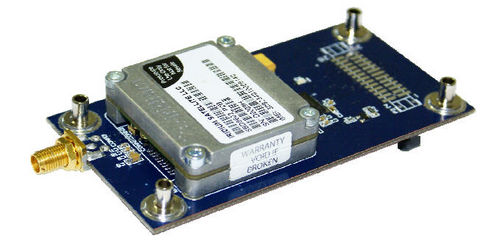
TELEMETRY - Telemetry information is relayed via Iridium 9612 every hour, which generated the screen shots via Google Maps. Scout uses two Arduino micro computers; one to navigate and one to communicate via an Iridium transceiver.
IRIDIUM QUAKE & BLUETRACKER SYSTEMS
QUAKE Q9612 MODEM Tech Specs
Length: 4.3 in. (109 mm)
BLUETRACKER
BlueTraker® FTM enables web
access and the ability to set alarms or warnings, guarantee the peace of mind and total security all around the globe.
IRIDIUM
OPENPORT BROADBAND
Be sure to visit the official Scout website at www.GoTransat.com
Astrium Serviceshttp://www.astriumservices.com Office Locations: Brazil, France, Germany, Hong Kong, Netherlands, Norway, Singapore, United Arab Emirates, United States
LiveTV LLChttp://www.LiveTV.net Office Locations: United States Otesat-Maritelhttp://www.otesat-maritel.com Office Locations: Greece
Globe Wireless, LLChttp://www.globewireless.com/communications/iridium Office Locations: United States Data Technology Solutionshttp://www.dtscom.com Office Locations: United States MVShttp://www.mvs.com.cy Office Locations: Cyprus, Russia, United States Applied Satellite Technology Ltdhttp://www.satcomms.com Office Locations: Australia, Singapore, South Africa, United Kingdom(2), United States Telaurus Communications LLChttp://www.telaurus.com Office Locations: United States
AND Group plchttp://www.and-group.net Office Locations: Brazil, Greece, Singapore, United Kingdom Geolink Satellite Serviceshttp://www.geolink.com Office Locations: France, Germany, United Arab Emirates KDDI Corporationhttp://www.kddi.com Office Locations: Japan
Gardline Communications Inc.http://www.gardlinecomms.us Office Locations: United Kingdom, United States Satlink Satellite Communication Ltd.http://www.satlink.com.cy Office Locations: Cyprus SatCom Globalhttp://www.satcomglobal.com Office Locations: Australia, Japan, Singapore, Thailand, United Kingdom, United States Horizon Mobile Communications Pte Ltdhttp://www.horizon-mobile Office Locations: Thailand Zunibal S.L.http://www.zunibal.com Office Locations: Spain Stratos Mobile Networkshttp://www.stratosglobal.com Office Locations: Australia(2), Canada(2), Germany, Hong Kong, Italy, Japan, Kenya, Netherlands, New Zealand, Singapore, South Africa, Spain, United Arab Emirates, United Kingdom, United States(6)
LINKS
http://www.bluetraker.com/solutions/fuel-monitoring/ https://twitter.com/ScoutTRANSAT https://www.facebook.com/ScoutTransatlantic http://www.wpri.com/on-air/green-team/ri-students-design-solar-powered-boat http://www.solarracing.org/2013/06/10/autonomous-solar-powered-boat-to-cross-the-atlantic/ http://letsmakerobots.com/node/38270 http://www.kickstarter.com/projects/601285608/scout-the-autonomous-transatlantic-boat http://www.kickstarter.com/help/school#defining_your_project http://www.kickstarter.com/start?ref=footer http://www.gotransat.com/ http://www.gotransat.com/tracking/ http://makezine.com/magazine/transatlantic-drone-takes-to-the-sea/ http://www.behance.net/gallery/SCOUT-Transatlantic/10153015 World
Sea
conditions, Temperatures
& Sunshine http://www.yellowbrick-tracking.com/ http://fishpi.org/wiki/index.php?title=The_Proof-Of-Concept_Vehicle http://fishpi.org/wiki/index.php?title=The_Prototype http://fishpi.org/wiki/index.php?title=Hull_Design http://www.raspberrypi.org/ http://international.findmespot.com/ http://www.amsat.org/
Blackcurrant 1 | Blackcurrant 2 | Catamaran Hull Design Drag | SWASH | SWATH | Trimaran
|
||
|
This website is Copyright © 2013 Bluebird Marine Systems Ltd. The names Bluebird™, Bluefish™, Solar Navigator™,Blueplanet Ecostar BE3™, Utopia Tristar™ and the blue bird and fish in flight logos are trademarks. The color blue is an essential element of the marks. All other trademarks are hereby acknowledged.
|
||