Jamestown Distributors, proud sponsors of Scout


SCOUT TRANSATLANTIC @ 60 DAYS

Autonomous transatlantic solar powered robot boat project

JD Jamestown Distributors


AUTONOMOUS NEWS UPDATE 2021


Following on from the Scout Atlantic bash in 2013, in 2020, a team comprising Promare, IBM, and many other technology partners, decided to attempt to cross the Atlantic against the prevailing winds and currents. They set out to build a 100ft craft named Mayflower Autonomous Ship (MAS) for launch and an attempt, aiming for the 400th anniversary of the Pilgrim Fathers journey starting on the 6th of September 1620.


They never made that date, partly due to Covid 19, but did manage to get a hull in the water for the ceremonies in Plymouth, Devon in 2020. On the 15th June 2021, the unmanned craft departed from Plymouth in England, aiming for Plymouth, Massachusetts, USA. You can follow the journey on their blog:  https://mas400.com/dashboard


Mayflower Autonomous Ship MAS 400 IBM and Promare Atlantic unmanned attempt 15 June 2021


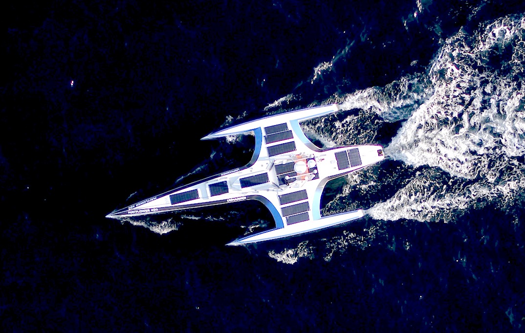
MAS 400 - The fully autonomous trimaran Setting off from Plymouth, England on the 15th June 2021. There are solar panels, that presumably add to the diesel-electric setup. The idea is to be COLREGs compliant with a self learning program, as such vessels build a database. Much the same as with the current bevy of self-driving robotaxis and robotracks. The question is therefore, will ships beat trucks to the autonomous punch?


SCOUT 60th DAY UPDATE - The general consensus is that Scout has wiped out. Someone suggested that the propeller might be fouled. We'd like to know, and maybe we'll find out if the boat is recovered. It is still one hell of an achievement. Hopefully, to be built upon as, when and if the team regroups/recovers their equilibrium.


Meantime, the present drift is interesting and we will follow it just to see where the vessel finally comes to rest. At the moment Scout is a reflection on Atlantic current status, save that one would not have anticipated the snaking - but perhaps that is a "message in a bottle" type of course. If she'd been fitted with wind velocity and temperature sensors, we'd have a clearer picture. Maybe, that is for the future. 


Scout continues her change in direction east towards the English Channel. Naughty Scout. We don't know what's happened, but she is not following any assigned course and we must assume the worst. Or, maybe she just became self aware (Hal). Maybe the currents are too strong to overcome - or, if the navionics have failed, could this be a robotic Mary Celeste? The 'purple' status indicators are not keyed on the tracking panel. Scout passed the 45 day milestone traveling at about 1.5 mph on a south-easterly course. She was closing on the half way point before turning west in a dramatic 'U' turn. Whatever happens now, Scout is the current distance record holder - an achievement that this team can be rightly proud. There is always another day to beat their own record. Come on Scout reset those arduinos for Spain ...... or find your way home .....


CONCEPT - Scout is a small unmanned boat of around 13 feet in length, powered by solar panels. The idea is to get across the Atlantic autonomously; that is without a crew onboard. The Scout team are using much the same gps, tracking and computer equipment as the Microtransat (sail powered) teams and other roboteers seem to favour. The design of a vessel is very important, it is what makes one vessel superior to another performance wise. Early students of boat design may enjoy learning of the various solar boat experiments we are building on. Some of which is very basic, but then basic principles are the core to a successful ship.


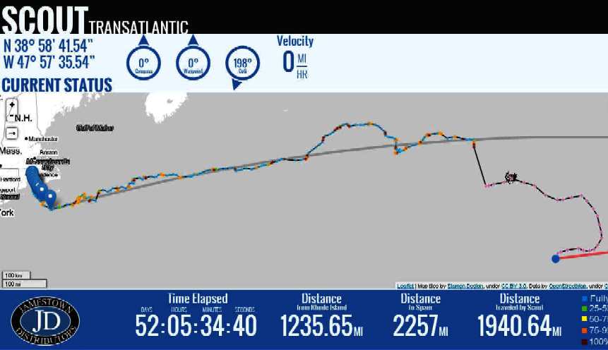
23 October 2013 STATS

Time Elapsed:60 DAYS: 04 HOURS: 05 MINUTES: 09 SECONDS
Distance from Rhode Island 1382.72 mi      Distance to Spain 2101 mi
Distance traveled by Scout 2198.73 mi       Velocity: 1.28 mph


Scout monitoring Atlantic ocean drift


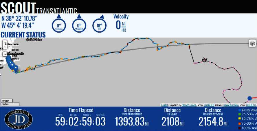
22 OCTOBER 2013 STATS

Time Elapsed: 59 DAYS: 02 HOURS: 59 MINUTES: 03 SECONDS
Distance from Rhode Island 1393.83 mi    Distance to Spain 2108 mi
Distance traveled by Scout 2154.8 mi       Velocity: 1.53 mph


CURRENT STATUS: N 38° 32’ 10.78” W 45° 4’ 19.4” Compass 0° Waypoint 0° CoG 18°


Scout transatlantic robot boat is drifting towards Europe slowly


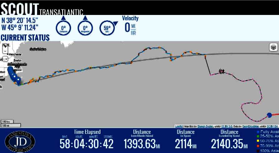
21 OCTOBER 2013 STATS

Time Elapsed: 58 DAYS: 04 HOURS: 30 MINUTES: 42 SECONDS
Distance from Rhode Island 1393.63 MI     Distance to Spain 2114 MI 
Distance traveled by Scout 2140.35           Velocity: 1.33 mph

CURRENT STATUS: N 38° 20’ 14.5” W 45° 9’ 11.24” Compass 0° Waypoint 0° CoG 59°


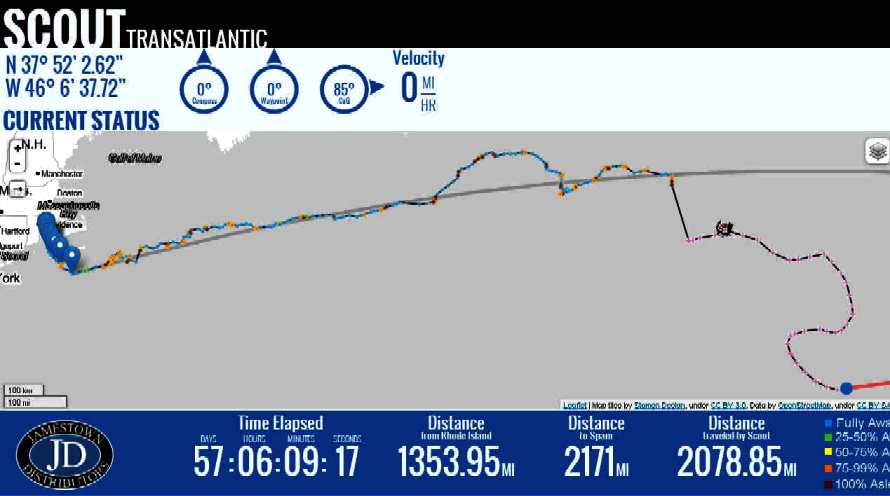
20 OCTOBER 2013 STATS

Time Elapsed: 57 DAYS: 06 HOURS: 09 MINUTES: 17 SECONDS
Distance from Rhode Island 1353.95 MI     Distance to Spain 2171 MI 

Distance traveled by Scout 2078.85           Velocity: 1.54 mph

CURRENT STATUS: N 37° 52’ 2.62” W 46° 6’ 37.72” Compass 0° Waypoint 0° CoG 85°


Scout gotransat robotic record crossing


19 OCTOBER 2013 STATS

Time 
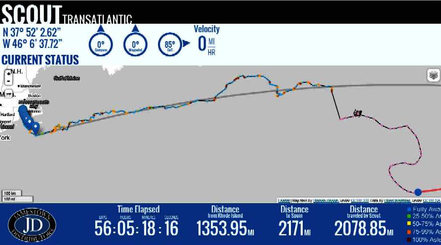
Elapsed: 56 DAYS: 05 HOURS: 18 MINUTES: 16 SECONDS
Distance from Rhode Island 1353.95 MI      Distance to Spain 2171 MI 

Distance traveled by Scout 2078.85            Velocity: 1.54 mph

CURRENT STATUS: N 37° 52’ 2.62” W 46° 6’ 37.72” Compass 0° Waypoint 0° CoG 85°


18 OCTOBER 2013 STATS

Time 
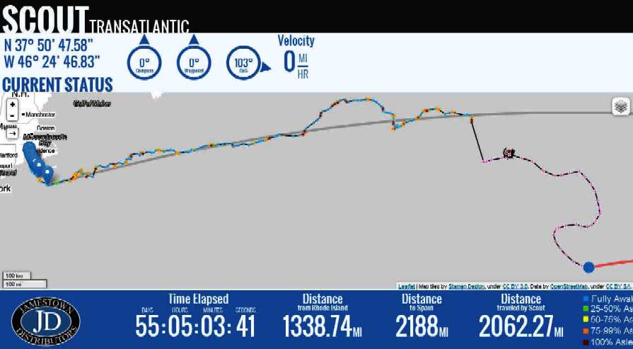
Elapsed: 55 DAYS: 05 HOURS: 04 MINUTES: 41 SECONDS
Distance from Rhode Island 1338.74 MI    Distance to Spain 2188 MI 

Distance traveled by Scout 2062.27          Velocity: 1.54 mph

CURRENT STATUS: N 37° 50’ 47.58” W 46° 24’ 46.83” Compass 0° Waypoint 0° CoG 103°


Scout drifting the Atlantic heading for Gambia, S. Africa


17 OCTOBER 2013 STATS

Time 
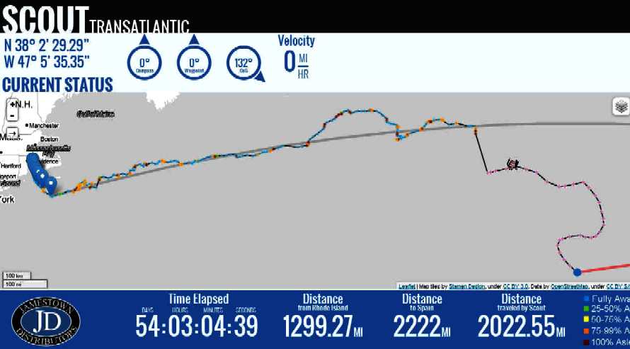
Elapsed:54 DAYS: 03 HOURS: 04 MINUTES: 39 SECONDS
Distance from Rhode Island 1299.27 MI      Distance to Spain 2222 MI 

Distance traveled by Scout 2022.55            Velocity: 1.95 mph

CURRENT STATUS: N 38° 2’ 29.29” W 47° 5’ 35.35” Compass 0° Waypoint 0° CoG 132°


Scout continues to drift south on the Atlantic Ocean


16 OCTOBER 2013 STATS

Time 
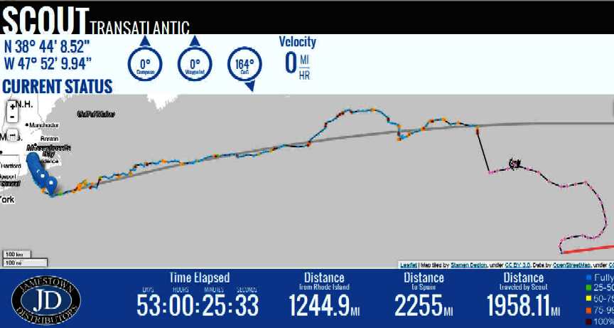
Elapsed: 53 DAYS: 00 HOURS: 25 MINUTES: 33 SECONDS
Distance from Rhode Island 1244.9 mi      Distance to Spain 2255 mi
Distance traveled by Scout 1958.11 mi      Velocity: 1.45 mph


CURRENT STATUS: N 38° 44’ 8.52” W 47° 52’ 9.94” Compass 0° Waypoint 0° CoG 164°


Scout is drifting south across the Atlantic


15 OCTOBER 2013 STATS

Time Elapsed: 52 DAYS: 05 HOURS: 34 MINUTES: 40 SECONDS
Distance from Rhode Island 1235.65 MI      Distance to Spain 2257 MI 
Distance traveled by Scout 1940.64            Velocity: 1.12 mph

CURRENT STATUS: N 38° 58’ 41.54” W 47° 57’ 35.54” Compass 0° Waypoint 0° CoG 198°


Scout heading west across the Atlantic for Florida


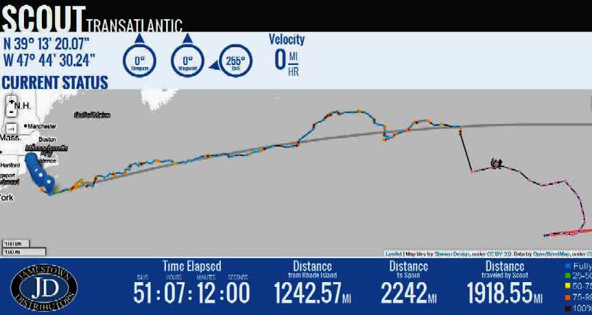
14 OCTOBER 2013 STATS

Time Elapsed: 51 DAYS: 07 HOURS: 12 MINUTES: 00 SECONDS
Distance from Rhode Island 1242.57 mi      Distance to Spain 2242 mi
Distance traveled by Scout 1918.55 mi       Velocity: 1.43 mph


CURRENT STATUS: N 39° 13’ 20.07” W 47° 44’ 30.24” Compass 0° Waypoint 0° CoG 255°


Scout has hit a hiccup - she's going back to Rhode Island


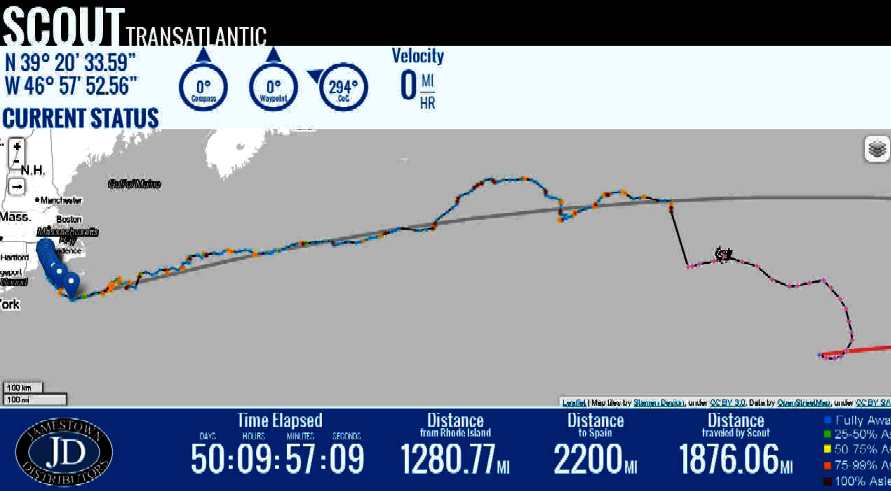
13 OCTOBER 2013 STATS

Time Elapsed: 50 DAYS: 09 HOURS: 57 MINUTES: 09 SECONDS

Distance from Rhode Island 1280.77 MI     Distance to Spain 2200 MI 

Distance traveled by Scout 1876.06           Velocity: 1.18 mph

CURRENT STATUS: N 39° 20’ 33.59” W 46° 57’ 52.56” Compass 0° Waypoint 0° CoG 294°


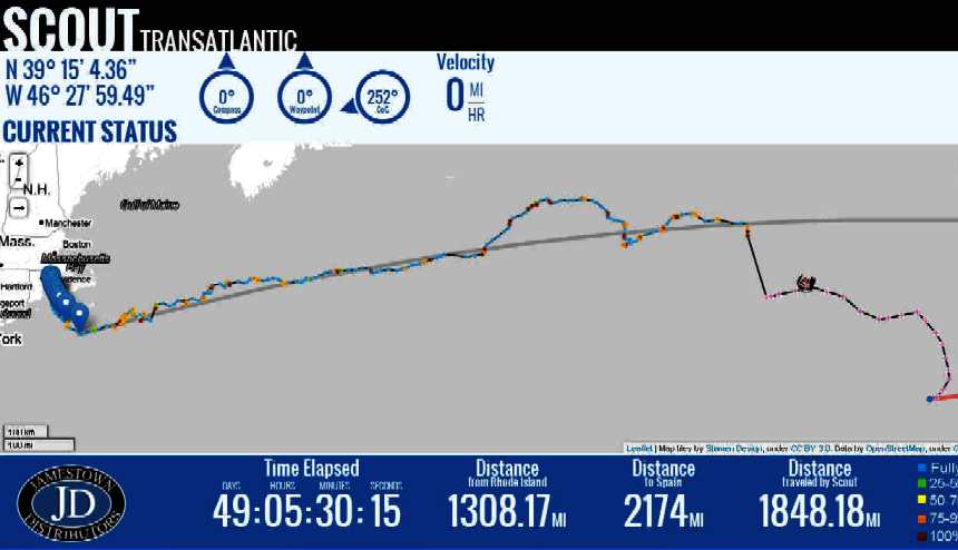
12 OCTOBER 2013 STATS

Time Elapsed: 49 DAYS:  05 HOURS:  30 MINUTES: 15 SECONDS
Distance from Rhode Island 1308.17 MI    Distance to Spain 2174 MI 

Distance traveled by Scout 1848.18          Velocity:  .92 mph

CURRENT STATUS: N 39° 15’ 4.36” W 46° 27’ 59.49” Compass 0° Waypoint 0° CoG 252°


11 OCTOBER 2013 STATS  (Snoopy Sloop is re-launched UK)

Time Elapsed: 48 DAYS: 05 HOURS: 45 MINUTES: 50 SECONDS
Distance from Rhode Island 1317.55 MI    Distance to Spain 2164 MI 

Distance traveled by Scout 1837.1            Velocity 1.19 mph

CURRENT STATUS: N 39° 17’ 58.32” W 46° 16’ 9.81” Compass 0° Waypoint 0° CoG 220°


The Atlantic robotic record crossing attempt 2013

Click on the image above to follow progress live


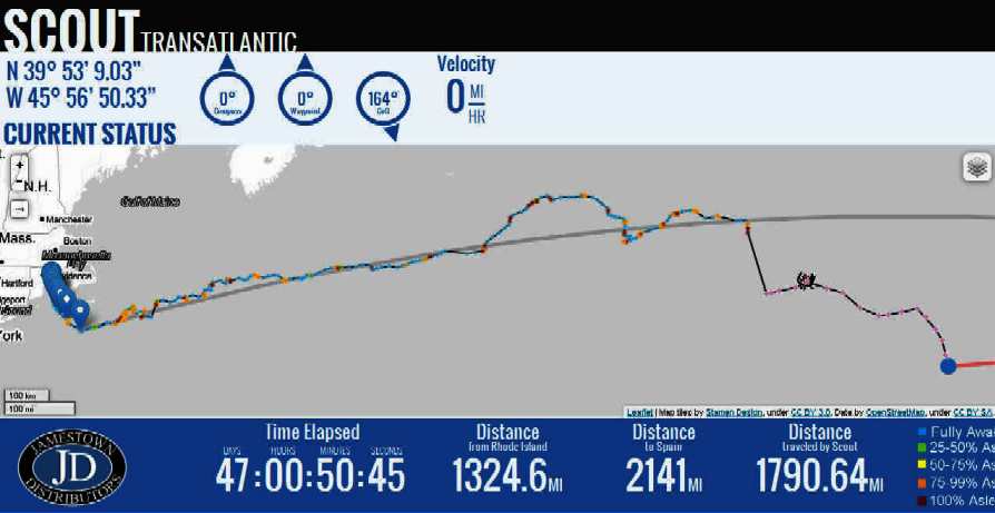
10 OCTOBER 2013 STATS

Time Elapsed:47 DAYS: 00 HOURS: 50 MINUTES: 45 SECONDS
Distance from Rhode Island 1324.6 mi    Distance to Spain 2141 mi
Distance traveled by Scout 1790.64 mi   Velocity not displayed


CURRENT STATUS: N 39° 53’ 9.03” W 45° 56’ 50.33” Compass 0° Waypoint 0° CoG 164°


9 OCTOBER 2013 STATS

Time Elapsed: 46 DAYS: 04 HOURS: 23 MINUTES: 27 SECONDS
Distance from Rhode Island 1307.15 MI      Distance to Spain 2146 MI 

Distance traveled by Scout 1750.37            Velocity 1.5 mph 

CURRENT STATUS: N 40° 27’ 4.39” W 46° 7’ 33.18” Compass 0° Waypoint 0° CoG 151°


Key to robotic phases during the expedition

Key to phases of robotic operation


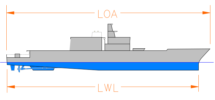
WATERLINE LENGTH - The waterline length (originally Load Waterline Length, abbreviated to LWL) is a measurement of ships and boats. The term denotes the length of the vessel at the point where it sits in the water. It excludes the total length of the boat, such as features that are out of the water. Most boats rise outwards at the bow and stern, so a boat may be quite a bit longer than its waterline length. In a ship with such raked stems, naturally the waterline length changes as the draft of the ship changes, therefore it is measured from a defined loaded condition.
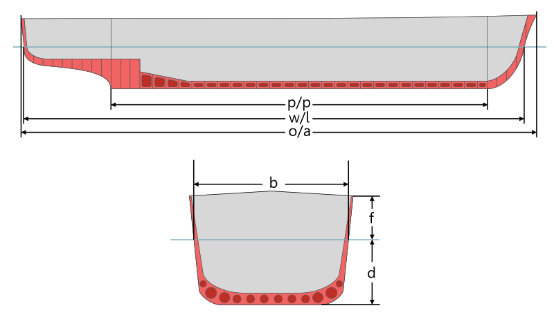
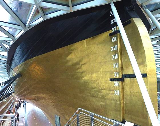

Length at the waterline is often abbreviated as lwl, w/l, w.l. or wl.  This measure is essential in determining a lot of properties of a vessel, such as how much water it displaces, where the bow and stern waves are, hull speed, amount of bottom-paint needed, etc.


DRAUGHT - The draft (or draught) of a ship's hull is the vertical distance between the waterline and the bottom of the hull (keel), with the thickness of the hull included; in the case of not being included the draft outline would be obtained. Draft determines the minimum depth of water a ship or boat can safely navigate. The draft can also be used to determine the weight of the cargo on board by calculating the total displacement of water and then using Archimedes' principle. A table made by the shipyard shows the water displacement for each draft. The density of the water (salt or fresh) and the content of the ship's bunkers has to be taken into account. The closely related term "trim" is defined as the difference between the forward and aft drafts.


DRAFTS OF A SHIP

* The draft aft (stern) is measured in the perpendicular of the stern.
* The draft forward (bow) is measured in the perpendicular of the bow.
* The mean draft is obtained by calculating from the averaging of the stern and bow drafts, with correction for water level variation and value of the position of F with respect to the average perpendicular.


Metric bow scale  Bow scale, English-Roman numeration


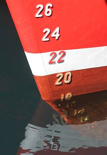
Metric and English (Roman) bow scales


Variations of the draft

The draft of a ship can be affected by multiple factors, not considering the rise and fall of the ship by displacement:

* Draft variation by list
* Draft variation by water level change
* Allowance of fresh water draft variation by passage from fresh to sea water or vice versa
* Heat variation in navigating shallow waters

DRAFT SCALE

The drafts are measured with a "banded" scale, from bow and to stern, and for some ships, the average perpendicular measurement is also used. The scale may use traditional English units or metric units. If the English system is used, the bottom of each marking is the draft in feet and markings are 6 inches high. In metric marking schemes, the bottom of each draft mark is the draft in decimeters and each mark is one decimeter high.


IMPLICATIONS - LARGE SHIPS

Larger ships try to maintain an average water draft when they are light (without cargo), in order to make a better sea crossing and reduce the effects of the wind (high centre of velic force). In order to achieve this they use sailing ballasts to stabilize the ship, following the unloading of cargo.

The water draft of a large ship has little direct link with its stability, the latter depends solely on the respective positions of the metacenter of the hull and the centre of gravity. It is also true however, that a "light" ship has quite high stability which can lead to implying too much rolling of the ship (due to memory). A fully laden ship (with a large draft) can have a strong or on the contrary, a weak stability, depending upon the manner by which the ship is loaded (height of the centre of gravity).

The draft of ships can be increased when the ship is in motion, a phenomenon known as squat (nautical term for the hydrodynamic effect of lower pressure pulling the ship down as it moves).

Draft is a significant factor limiting navigable waterways, especially for large vessels. Of course this includes many shallow coastal waters and reefs, but also some major shipping lanes. Panamax class ships—the largest ships able to transit the Panama Canal—do have a draft limit (and an "air draft" limit for passing under bridges) but are usually limited by beam, or sometimes length overall, for fitting into locks. However in the much wider Suez Canal, the limiting factor for Suezmax ships is draft. Some supertankers are able to transit the Suez Canal when unladen or partially laden, but not when fully laden.

Canals are not the only draft-limited shipping lanes. A Malaccamax ship has the deepest draft able to transit the very busy but relatively shallow Strait of Malacca. There are only a few ships of this size.


PLEASURE BOATS

A small draft allows pleasure boats to navigate through shallower water. This makes it possible for these boats to access smaller ports, to travel along rivers and even to 'beach' the boat.


A large draft ensures a good level of stability in strong wind, as the centre of gravity is lower (ballast over the keel of the boat). For example: Ballasts placed very low in the keel of a boat such as a dragon boat with a draft of 1.20 m for a length of 8.90 m.


A boat like a catamaran can mitigate the problem by retrieving good stability in a small draft, but the width of the boat increases.

SUBMARINES

For submarines, which can submerge to different depths at sea, a term called keel depth is used, specifying the current distance from the water surface to the bottom of the submarine's keel. It is used in navigation to avoid underwater obstacles and hitting the ocean bottom, and as a standard point on the submarine for depth measurements.

Submarines usually also have a specified draft used while operating on the surface, for navigating in harbors and at docks.


Scout Video


Make sure to visit the Scout team website at www.GoTransat.com


LINKS


https://twitter.com/ScoutTRANSAT

https://www.facebook.com/ScoutTransatlantic

http://www.wpri.com/on-air/green-team/ri-students-design-solar-powered-boat

http://www.solarracing.org/2013/06/10/autonomous-solar-powered-boat-to-cross-the-atlantic/

http://letsmakerobots.com/node/38270

http://www.kickstarter.com/projects/601285608/scout-the-autonomous-transatlantic-boat

http://www.kickstarter.com/help/school#defining_your_project

http://www.kickstarter.com/start?ref=footer

http://www.gotransat.com/

http://www.gotransat.com/tracking/

http://makezine.com/magazine/transatlantic-drone-takes-to-the-sea/

http://www.behance.net/gallery/SCOUT-Transatlantic/10153015
www.marinetraffic.com - busy shipping lanes
UK Winds , Sailflow Winds , Met Office Rain & Wind

World Sea conditions, Temperatures & Sunshine
windfinder.com or magicseaweed.com for expected wave heights

http://www.python.org/

Scout on Facebook

http://www.yellowbrick-tracking.com/

http://fishpi.org/wiki/index.php?title=The_Proof-Of-Concept_Vehicle

http://fishpi.org/wiki/index.php?title=The_Prototype

http://fishpi.org/wiki/index.php?title=Hull_Design

http://www.raspberrypi.org/

http://international.findmespot.com/

http://www.amsat.org/


Blackcurrant 1  |  Blackcurrant 2  |  Catamaran  Hull Design  Drag  |  SWASH  |  SWATH  |  Trimaran


This website is Copyright © 2013 Bluebird Marine Systems Ltd.   The names Bluebird™, Bluefish™, Solar Navigator™,Blueplanet Ecostar BE3™, Utopia Tristar™ and the blue bird and fish in flight logos are trademarks. The color blue is an essential element of the marks. All other trademarks are hereby acknowledged.


  Bluebird trademark legend, blue bird in flight logoBluefish flying fish autonomous robotic ships navigation system