|

For naval forces, the classical terms
“blue water” threat and “major threat axis” no longer hold the significance they
once did. The threat environment has shifted from “blue water” to “brown
water,” or littoral regions, placing emphasis on power projection, force protection,
and expeditionary operations in littoral areas. The term “asymmetric threat”
with terrorist actions a frequent occurrence, requires persistent monitoring to
forewarn of the origins of threats with increased intel.
Along with this change in emphasis, new capabilities will be required of naval forces in the areas of: 1.
Maritime intelligence; 2.
Surveillance and reconnaissance (ISR); 3.
Oceanographic bathymetric surveys; 4.
Battlespace preparation; 5.
Battlespace awareness; 6.
Mine warfare; 7.
Anti-submarine
warfare (ASW); 8.
Special operations and strike support; 9.
Surface warfare (including interdiction); 10.
Littoral ASW with emphasis on diesel submarines; and base and port security. Particular areas of weakness that
have been identified with respect to the needed capabilities include organic mine
countermeasures, littoral ASW, and defense against small boats.
In turn, the kinds of missions listed above place a premium on integrated, persistent
ISR; command, control, and communications (C3); and distributed, real-time knowledge. The increasing needs arising from the new threats may be
alleviated, to a growing extent, by exploiting the benefits of unmanned systems,
leveraged by networking sensors and communications to the greatest possible advantage, and using unmanned surface vehicles (USVs) and unmanned undersea
vehicles (UUVs) as nodes in sensor and communications networks.
ASV BACKGROUND
Naval use of unmanned surface vehicles has a long history, beginning soon after World War II with
deployments of remotely controlled target drones and mine sweepers. Recently, there has been enhanced interest in developing and
using USVs for reconnaissance, surveillance, and mine-hunting missions in more
nearly autonomous modes, as well as a continued use of the target drones.
To date, USVs have received neither the acceptance nor the attention in the Navy that has been given to other unmanned vehicles (unmanned ground vehicles
(UGVs), unmanned aerial vehicles (UAVs), and UUVs). In particular, the Navy has no approved USV master plan. It appears that efforts regarding USV
launch and -
recovery systems on surface platform hosts have limited emphasis. The number of USVs in existence or being developed is small compared with that of UGVs, UAVs, and UUVs. Three unmanned surface
vehicles - the Spartan, Owl, and Roboski (specifications below) - are mentioned frequently
as candidates for naval use. The Remote Minehunting System (RMS), usually considered a UUV, is in fact a semisubmerged, air-breathing
USV. TECHNOLOGY
AVAILABILITY
Most of the technology necessary for the development of USVs is mature and available. High-speed,
low-observability, agile surface vehicles with acceptable endurance could be developed at reasonably low cost. However, various
engineering aspects of these systems have not been adequately addressed,
including how they will communicate with one another, with other unmanned vehicles, and with manned
undersea, surface, and air systems; what sensor suites they might employ; and how they would best be
launched and recovered.
Current USV systems are used in a remotely controlled
mode. Opportunities
for these systems, if used in an autonomous and adaptive control mode are significant. For example, the increasingly hazardous
mine-hunting process typically
requires the acquisition of potential targets in order to identify, classify, and
neutralize hazards. The cooperative action of multiple USVs with a broad range of
sensing capabilities has the potential to improve mine-hunting capability significantly.
Similarly, with multiple vehicles there is important potential for improvements in coverage rates for
environmental and other survey missions if adaptive or
intelligent autonomous control schemes become available, such as that being
developed by Bluebird Marine Systems in the United Kingdom.
USVs appear to have promise for shallow water ASW and for countering swarms of small boats. USVs could also be assigned clandestine logistic roles to
deliver and place seafloor sensors or seafloor energy sources for later use by UUVs, to shoot ground sensors ashore, to deploy seafloor or midwater acoustic
arrays, or to place logistics packages in support of SEAL (sea, air, and land) teams or Special Operations Forces. Also, as discussed earlier, they could collect
oceanographic data necessary to provide environmental information in support of warfighter systems and to detect the presence of chemical and biological agents.
US NAVAL USVs 2005:
• The autonomous search and hydrographic (ASH) vehicle and the Roboski were developed in the 1990s, initially as jet-ski type target drones for ship
self defense training. They are now also used as reconnaissance vehicle
test-beds. They operate as remotely controlled vehicles and therefore are confined to
line of -
sight operation.
• The Owl USV is a commercially available modification of ASH, with a
low-profile hull for increased stealth and payload, operated as well in a remotely
controlled mode. It has been used in demonstrations for marine reconnaissance in
riverine and littoral situations. Today, several variants for stealthy USV sensor
platforms have been proposed and are under consideration by the naval forces.
• The Spartan USV is an Advanced Concept Technology Demonstration
(ACTD) started in May 2002. It is a modular concept, adapted to a 7-m-long rigid
hull inflatable boat (RHIB) and fitted with various sensor and mission modules. It
will be demonstrated in mine warfare, force protection, and precision strike scenarios, as well as for command and control of multiple USVs. This prototype
system will have an endurance of up to 8 hours, a range of 150 nautical miles, transit speeds greater than 28 knots, and payloads of up to 2,600 lb. A larger
version is contemplated based on an 11 m RHIB, with correspondingly larger payload and endurance. • The Remote Minehunting System’s (RMS) mission is to detect, classify, localize,
and identify bottom and moored mine threats in shallow and deep water. It is an air-breathing, diesel-powered
semi-submersible that autonomously follows a preplanned mission plan. The vehicle deploys a variable depth sensor (VDS),
comprising acoustic and EO sensors to positively identify objects as mines or
non-mines. The VDS is the AN/AQS-20 airborne mine reconnaissance sensor, containing a suite of five acoustic sensors and the EO mine warfare sensor. The
data link sends information collected by the VDS back to the host ship via line
of - sight or over-the-horizon transmissions. The first installations are planned for
Aegis destroyers DDG 91 through DDG 96. System mission command, control, and display are incorporated into the AN/SQQ-89(V)15 undersea warfare combat
system and operated by the host ship.
The RMS concept of employment starts with a launch of the remote, mine-hunting vehicle with its towed sensor package from the destroyer (DDG). The
vehicle transits to the reconnaissance area prior to the DDG’s entering the immediate
area, and it conducts area reconnaissance by executing a preprogrammed mission profile. The processing onboard the RMS detects, classifies, and localizes
minelike objects. Target imagery data and precise locations where data were gathered are radioed back to the DDG. The data are processed onboard the DDG
to positively determine if the minelike object is indeed a mine. This process can
be operator-initiated or automatic.
As mentioned above, this vehicle is large, almost 14,000 lb with the VDS, and is awkward to deploy or recover in any sea state above sea state 3. However,
dedicated handling gear for deployment and recovery from the ship has been developed.
SPECIFICATION OF USVs 2005
Vehicle Endurance Depth (m)
Speed Payload Dimension (FY)
Spartan 8.0 h
0 >28 kt 2,600 lb
7.0 m length TBD
Owl 7.5 h
0 <45 kt
1,100 lb
9.7 ft
TBD
Roboski 50 nmi
0
>42 kt 460 lb 9.0 ft
TBD
SEMI AUTONOMOUS HYDROGRAPHIC RECONNAISSANCE VEHICLE SYSTEM (SAHRV)
Expeditionary Warfare developed the SAHRV system, which is a modification of a
system, called Remote Environmental Monitoring Unit System (REMUS), developed for routine autonomous surveys in coastal regions for the research community.
This SAHRV system is widely used in the research community. It is human-portable (80 lb) and is equipped with sensors to measure conductivity,
temperature, water depth, and optical backscatter. It has a side-scan sonar as well as an up-down-looking acoustic Doppler current profiler. Its modular design
facilitates the installation of additional sensors, such as for bioluminescence.
Navigation is provided using a short-baseline acoustic system. Control is exercised through a laptop computer that implements simple waypoint commands.
Planned improvements in the SAHRV system include computer-aided detection and classification, digital acoustic communications, upward-looking detection
sonar, forward-looking obstacle-avoidance sonar, and precision navigation. In addition, an adaptive control system is under development that will allow
dynamic reprogramming of a mission by an operator via acoustic communications or by threshold detection of onboard sensors. An adaptive control system
allows the vehicle to follow a plume to its source or to determine regions of maximum concentration of bioluminescent organisms or pollutants. In addition,
the capability for the vehicle to dock at a remote docking station, download the
accumulated data, and recharge its batteries has been demonstrated.
PMS Explosive Ordnance Detachment is developing vehicles based on the REMUS platform to counter the threat of unexploded ordnance and reduce the
threat to the Navy’s teams. The detachment is also developing a vehicle to conduct
mine reconnaissance in shallow waters (10 to 40 ft deep) close to hostile shores and is working to have an initial operating capability by mid-FY03 and
full operational capability by FY05. Concurrent developmental efforts include vehicles to conduct harbor search and the clearance and reconnaissance of waters
up to 300 ft deep and, leveraging the Joint Robotics Program, to develop ground crawlers to work in the surf zone. REMUS was used in Operation Iraqi Freedom
by Special Forces, and it was used for explosive ordnance disposal in mine reconnaissance missions in the waterway and in the port of Umm Qasr.
LONG
RANGE MINE RECONNAISSANCE SYSTEMS
The Long-range Mine Reconnaissance System (LMRS) is a UUV designed to be launched and recovered from a submerged submarine while it is under way
at very low speed. The primary purpose of the LMRS is to extend the submarine’s
capability to conduct mine reconnaissance in clandestine fashion. The system is planned for the Virginia-class SSNs and nuclear-powered guided-missile submarines
(SSGNs). LMRS launch requires a dedicated torpedo tube, and the recovery system occupies an additional torpedo tube, representing a considerable loss of
flexibility for other kinds of submarine operations. The LMRS is a follow-on to the Near-Term Mine Reconnaissance System (NMRS), which was built to meet
the specific needs of the submarine community to have a semiautonomous vehicle to perform reconnaissance ahead of the submarine.
The NMRS was built
using technology available in tethered torpedoes and sensors used by the mine countermeasures communities. The NMRS is tethered to communicate information
back and forth, but the system is recoverable, unlike torpedoes. Four NMRSs were built and were deployed on selected submarines from 1998 to 2003. By
meeting the specific needs of the Navy, the NMRS program can be considered a success.
One LMRS vehicle and a dedicated submarine launch-and-recovery system are in prototype development, with a planned IOC in FY05. It is apparent that the
project is currently well behind schedule and over budget, to the extent that it has
triggered an Office of the Secretary of Defense (OSD)-level review of whether to
continue as originally planned. It is likely that an IOC in FY05 is not possible.
The technical problems of the LMRS in the areas of power and of navigation and launch and recovery are as follows. Given the 21 in. diameter of the vehicle,
prescribed by the standard torpedo tube, the LMRS vehicle requires a great deal of power to provide sufficient speed for stability, as well as sufficient endurance
to provide realistic standoff and surveying capability. The Navy has chosen to use
high energy density, lithium thionyl chloride batteries, which have required an extensive and long process to be qualified for use in the vehicle’s hull. While this
may ultimately be a good solution for the energy, it has certainly created additional
delays in the program.
There are, in the committee’s view, several technical
deficiencies in this system, exclusive of the sensor package. The vehicle used an inertial navigation system, which may not achieve the level of accuracy required
for the countermine mission; for such a mission, the objects being sought are of a scale smaller than the anticipated navigation error. Additionally, the
launch-and-recovery system is cumbersome, requiring the attachment of an arm to the returning vehicle and then the insertion of the vehicle into the torpedo tube.
This is a delicate process at best, when demonstrated by the mock-up system built
on a floating dock—it is going to be problematic in real-world environments, especially given the limited stability and maneuverability of the LMRS vehicle at slow speeds.
UNMANNED SURFACE AND UNDERSEA VEHICLES
As said above, this system, however flawed, needs to be used so that the Navy can begin to learn how to use a UUV for its ISR and countermine missions,
and from this real-world experience develop appropriate CONOPS. If the OSD review triggered by the delays and budget growth results in a cancellation of the
LMRS program, no experience will have been gained.
At present, the LMRS sensor package is similar to the package described above for the RMS
(AN/AQS-20) - essentially the same variable-depth sensor suite used for airborne mine reconnaissance. Forward- and side-looking sonars
are planned for IOC, and other sensors, such as synthetic aperture sonar (SAS) and improved acoustic communications systems (ACOMMS), will be added as
they become available. These are currently scheduled to be added in FY06, to provide near-identification-quality imaging. The Precision
Underwater Mapping System (PUMA) will be added in FY08, to increase the probability of detection
of mines and to provide bathymetry capability as well.
The most significant limitation of the LMRS and the NMRS is their endurance,
determined largely by the volume available for energy. In order to provide space for much larger payloads as well as the energy needed to support longer
missions, a larger-diameter system is in conceptual development. NAVAL OPERATIONAL NEEDS AND TECHNOLOGY ISSUES
The key naval operational needs and technical issues to be resolved in order to facilitate unmanned surface and undersea vehicles are delineated below. Some are common issues for both the USVs and UUVs:
• Autonomous adaptive control systems, able to utilize sensor data in navigational
and sensor control decisions. This operational need requires extensive
sensor fusion and onboard processing capabilities. Advances in adaptive autonomy
are crucial for fulfillment of the needs discussed earlier. • Sensor packages to provide positive identification of mines and other
objects of interest. Meeting this need will require high-resolution, acoustic, and
optical sensors whose prototypes are currently in development. • In-stride capability. This requirement involves timely detection, identification,
and neutralization of mines or other hazards in the sea-lanes of communications and supply, as well as in the littoral regions. • Launch-and-recovery systems for both USVs and UUVs a high priority. This class of needs is most likely platform-specific, not “one size fits all,” although
the concepts may be generalized. Without safe and reliable recovery systems and adequate checkout and maintenance space, operations will be dangerous,
critical learning in real-world environments will be prolonged, and the acceptance of unmanned vehicles in the fleet will be delayed. Of particular significance
in this context is the need for the planning and development of launch and - recovery systems for the Littoral Combat Ship

Operation
Neptune - An
advanced nuclear submarine is hijacked by environmental extremists intent on
stopping pollution from the burning of fossil fuels. The extremists torpedo a
number of oil wells as part of a campaign to cause energy chaos, with bigger
plans to come. If you enjoyed Under Siege or The Hunt for Red October, this is a
must for you.
LINKS
& REFERENCE
http://www.nap.edu/catalog/11379.html

ACRONYMS
& ABBREVIATIONS A-Z
AAV advanced air vehicle
ACLS Automated Carrier Landing System
ACOMMS acoustic communications systems
ACTD Advanced Concept Technology Demonstration
AEHF advanced extremely high frequency
AEW airborne early warning
AFOSR Air Force Office of Scientific Research
AFRL Air Force Research Laboratory
AGS Advanced Gun System
AGV automated guided vehicle
AINS Autonomous Intelligent Network and Systems (initiative)
AIP Antisurface Warfare Improvement Program
ANS Autonomous Navigation System
AOE automated ordnance excavator
AOSN Autonomous Ocean Sampling Network
ARL Army Research Laboratory
ARPA Advanced Research Projects Agency
ARTS All Purpose Remote Transport System
ARV armed robotic vehicle
ASH autonomous search and hydrographic (vehicle)
ASM antiship missile
ASN(RD&A) Assistant Secretary of the Navy for Research, Development,
and Acquisition
ASW antisubmarine warfare
ATD Advanced Technology Demonstration
AV autonomous vehicle
AWACS Airborne Warning and Control System
BAMS Broad Area Maritime Surveillance
BPAUV battlespace planning autonomous underwater vehicle
BUGS Basic Unexploded Ordnance Gathering System
C2 command and control
C2S Command and Control System
C2V command and control vehicle
C3 command, control, and communications
C3I command, control, communications, and intelligence
C3ISR command, control, communications, intelligence, surveillance,
and reconnaissance
C4 command, control, communications, and computers
C4I command, control, communications, computers, and intelligence
C4ISR command, control, communications, computers, intelligence,
surveillance, and reconnaissance
CAP combat air patrol
CAS close air support
CDL common data link
CECOM Communications Electronics Command
CENTAF U.S. Air Force, U.S. Central Command
CHBDL common high-bandwidth data link
CLF Combat Logistics Force
CMC Commandant, Marine Corps
CNO Chief of Naval Operations
CNR Chief of Naval Research
COMINT communications intelligence
CONOPS concept(s) of operations
CONUS continental United States
COTS commercial off-the-shelf
CRW canard rotor wing
CSG Carrier Strike Group
CSP constraint satisfaction problem
CTFF Cell Transfer Frame Format
CU Cruise Missiles and Unmanned Aerial Vehicles
CV/LH aircraft carrier/amphibious assault ship
CWSP Commercial Wideband Satellite Program
D7G combat engineering vehicle
DARPA Defense Advanced Research Projects Agency
DDG destroyer
DD(X) future destroyer
DEAD destruction of enemy air defense
DEUCE deployable universal combat earthmover
DOD Department of Defense
DSV deep submergence vehicle
ECM electronic countermeasures
EHF extremely high frequency
ELINT electronic intelligence
EM/EO electromagnetic/electro-optical
EMS electromagnetic sensing
EMW Expeditionary Maneuver Warfare
EOD Explosive Ordnance Disposal
EO/IR electro-optical/infrared
ESG Expeditionary Strike Group
FCS Future Combat System (Army)
FDI fault detection and isolation
FDOA frequency difference of arrival
FLT CNTL flight control
FMEA failure modes and effects analysis
FNC Future Naval Capability
FOC final operational capability
FP force protection
FYDP Future Years Defense Program
Gbps gigabits per second
GBS Global Broadcast System
GEOS Geosynchronous Earth Orbit Satellite
GHMD Global Hawk Maritime Demonstration
GHz gigahertz
GIG Global Information Grid
GIG-BE Global Information Grid-Bandwidth Expansion
GIG-E Globat Information Grid-Expansion
GMTI ground moving target indicator
GPS Global Positioning System
HAE high-altitude and -endurance
HALE high-altitude, long-endurance
HDTV high-definition television
HMMWV high mobility multipurpose wheeled vehicle
IMINT imagery intelligence
IMU inertial measurement unit
INMARSAT International Maritime Satellite
INTELSAT Intelligence Satellite
IOC initial operating capability
IP Internet Protocol
IR infrared
ISR intelligence, surveillance, and reconnaissance
ISR&T intelligence, surveillance, reconnaissance, and targeting
JDAM joint direct attack munition
JFACC Joint Forces Air Component Commander
JMPS Joint Mission Planning System
JPALS Joint Precision Approach and Landing System
JPO Joint Program Office
JSTARS Joint Surveillance Target Attack Radar System
JTF joint task force
JTRS Joint Tactical Radio System
J-UCAS Joint Unmanned Combat Air System
JWICS Joint Worldwide Intelligence Communications System
kbps kilobits per second
LADAR laser detection and ranging
LCS Littoral Combat Ship
L/D lift to drag (ratio)
LD MRUUV large-diameter multi-reconfigurable UUV
LDR low data rate
LDUUV long-distance unmanned undersea vehicle
LEOS Low Earth Orbiting Satellite
LHA amphibious assault ship (general purpose)
LHD amphibious assault ship (multipurpose)
LIDAR light detection and ranging
LMRS Long-range Mine Reconnaissance System
LOA level of autonomy
LOS line of sight
LPD amphibious transport dock
LRE launch-and-recovery element
LRIP low-rate initial production
MAE medium-altitude and -endurance
MAGTF Marine Air Ground Task Force
MARS Mobile Autonomous Robot Software
MMA Matilda Mesa Associates’ Tactical Integrated Light-force Deployment Assembly
MCCDC Marine Corps Combat Development Command
MCE mission control element
MCG&I mapping, charting, geodesy,and imagery
MCWL Marine Corps Warfighting Laboratory
MDA Missile Defense Agency
MDARS-E/I Mobile Detection Assessment Response System-Exterior/Interior
MDR medium data rate
MEB Marine Expeditionary Brigade
MEF Marine Expeditionary Force
MICA Mixed Initiative Control of Automa-teams (program)
MILSATCOM military satellite communications
MMS Mission Management System
MPF Maritime Prepositioning Force
MPF(F) Maritime Prepositioning Force (Future)
MPM mission payload module
MP-RTIP Multi-Platform Radar Technology Insertion Program
MRD Maritime Reconnaissance Demonstration (program)
MRUUV multi-reconfigurable UUV
MTI moving target indicator
MULE multifunction utility logistics equipment (vehicle)
NASA National Aeronautics and Space Administration
NAVAIR Naval Air Systems Command
NAVSEA Naval Sea Systems Command
NBC nuclear, biological, and chemical
NII Networks and Information Integration
NMRS Near-term Mine Reconnaissance System
NRAC Naval Research Advisory Committee
NRC National Research Council
NRL Naval Research Laboratory
NRO National Reconnaissance Office
NSWC/CD Naval Surface Warfare Center/Carderock Division
NUWC Naval Undersea Warfare Center
NWDC Navy Warfare Development Command
O&S operations and support
OASD Office of the Assistant Secretary of Defense
OAV organic aerial vehicle
OCU operator control unit
ODIS Omni-Directional Inspection System
OMFTS Operational Maneuver From the Sea
ONR Office of Naval Research
OODA observe-orient-decide-act
OPNAV Office of the Chief of Naval Operations
OSD Office of the Secretary of Defense
OSD(NII) Office of the Secretary of Defense (Networks and Information Integration)
OTH over-the-horizon
Packbot versatile platform for military products
PEO Program Executive Office
Perceptor Perception for Offroad Robotics
PFPS Portable Flight Planning System
PM-PSE Program Manager-Physical Security Equipment
PMS Program Management Office
PUMA Precision Underwater Mapping System
QDR Quadrennial Defense Review
R&D research and development
RCSS Remote Combat Support System
REMUS Remote Environmental Monitoring Unit System
RF radio frequency
RHIB rigid hull inflatable boat
RMP Radar Modernization Program
RMS Remote Minehunting System
RONS Remote Ordnance Neutralization System
ROV remotely operated vehicle
RSTA reconnaissance, surveillance, and target acquisition
RTIP Radar Technology Improvement Program
S&T science and technology
SA situation awareness
SAHRV semiautonomous hydrographic reconnaissance vehicle
SAM surface-to-air missile
SAR synthetic aperture radar
SAS synthetic aperture sonar
SATCOM satellite communications
SBR space-based radar
SDD System Development and Demonstration
SDR Software for Distributed Robotics
SEAD suppression of enemy air defense
SEAL sea, air, and land (teams)
SFC specific fuel consumption
SHF superhigh frequency
SIGINT signal intelligence
SIPRNET Secret Internet Protocol Router Network
SLAM simultaneous localization and mapping
SOC Special Operations-Capable
SPAWAR Space and Naval Warfare Systems Command
SRS Standardized Robotics System
SSGN nuclear-powered guided-missile submarine
SSN nuclear-powered submarine
STOM Ship-to-Objective Maneuver
TALON one robot solution to a variety of mission requirements
TAR tactical autonomous robot
TCA Transformational Communications Architecture
TCDL tactical common data link
TCO Transformational Communications Office
TCP Transmission Control Protocol
TCS Tactical Control System
TDOA time difference of arrival
TPED task, process, exploit, disseminate
TPPU task, post, process, use
TRL Technology Readiness Level
TUAV tactical unmanned aerial vehicle
UAV unmanned aerial vehicle
UCAR unmanned combat armed rotorcraft
UCAV uninhabited combat air vehicle
UCAV-N uninhabited combat air vehicle-Navy
UCS Unmanned Control System
UGCV Unmanned Ground Combat Vehicle (program)
UGS unattended ground sensor
UGV unmanned ground vehicle
UHF ultrahigh frequency
UNITE UAV National Industry Team
URBOT urban robot
USAF U.S. Air Force
USN U.S. Navy
USV unmanned surface vehicle
USW undersea warfare
UUV unmanned undersea vehicle
UXO unexploded ordnance
VDS variable depth sensor
VHF very high frequency
VMS Vehicle Management System
VSSN Virginia-class submarine
VSW/SZ Very Shallow Water/Surf Zone (program)
VTOL vertical takeoff and landing
VTUAV vertical-takeoff-and-landing tactical unmanned aerial vehicle
WHOI Woods Hole Oceanographic Institution
WNW wideband network wave form
XUV experimental unmanned vehicle

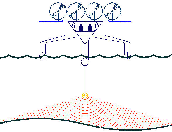
The
key to accurate hydrographic mapping is continuous monitoring,
for which the SNAV
platform, presently under development, is a robotic ocean workhorse. Based on a stable
SWASH
hull this design is under development by a consortium of British
engineers. The robot
ship uses no diesel fuel to monitor the oceans autonomously (COLREGS
compliant) at relatively high
speed 24/7 and 365 days a year - only possible with the revolutionary (patent) energy harvesting system. The
hullform is ideal for automatic release and recovery of ROVs
or towed arrays, alternating between drone and fully autonomous modes.
UK and international development partners are welcome. This vessel
pays for itself in fuel saved every ten years.
|


