|

Ian
Moncrieff and Mike Robinson (retiring Chief Exec UKHO)
IS
THE UK DOING ITS BIT?
The United Kingdom Hydrographic Office (or UKHO) is an organisation within the UK government responsible for providing navigational and other hydrographic information for national, civil and defence requirements. The UKHO is located in Taunton, Somerset on Admiralty Way and has a workforce of approximately 1000 staff.
The office is a Trading Fund of the Ministry of Defence and is directly responsible to the Parliamentary Under-Secretary of State and Minister for Veterans. The current minister is Andrew Robathan, MP. The Chief Executive of the agency is Ian Moncrieff, BA, CBE who took over in October 2011. The agency is self-funding and its Trading Fund status allows protection of the
copyright in its publications.
Rear-Admiral Tom Karsten is the current UK National Hydrographer and Deputy Chief Executive (Hydrography). He took up the post in December 2012.
The UKHO launched the Admiralty Vector Chart Series in April 2008 and the e-Navigator Service in 2009, which brings together all of the information needed for safe navigation, voyage planning and efficient fleet management in one place.
UKHO
OWNERS COUNCIL
The
owner is the Under Secretary of State for Defence and Minister for Veterans.
The owner's council is a group of senior stakeholders from across government and the marine industry. The council meets as necessary to discuss and advise the owner on how he/she can meet his/her responsibilities.
Rear Admiral
Rear Admirals Tom Karsten and Nick Lambert (retiring Hydrographer UKHO)
HYDROGRAPHIC OFFICE BOARD & MEMBERS
Our Board is led by an independent, non-executive chair Sandra Rogers. It acts with delegated authority from the owner. Its' main role is to support and constructively challenge the Executive Committee and to apply scrutiny both in the development of business strategies, cases, plans and targets; and in assessing our success in delivering the approved corporate plan. Please click here for a list of members.
Sandra Rogers - Non-Executive Chairman
Capt Steve Malcolm RN - Hydrographer of the Navy / Non-Executive Director
Barry Wootton - Non-Executive Director
Gareth Lewis - Non-Executive Director
Peter Shortt - MOD Directorate of Business Strategy & Governance / Non-Executive Director
Philippa Childs - Trade Union representative
Ian Moncrieff CBE - Chief Executive
RAdm Tom Karsten - National Hydrographer
John Humphrey - Commercial Director
ECDIS OVERVIEW
- THE ECDIS MANDATE
The International Maritime Organization (IMO) approved amendments to the International Convention for the Safety of Life at Sea
(SOLAS) mandating the fitting of Electronic Chart Display Information System (ECDIS) at the 86th session of the Maritime Safety Committee (MSC) in June 2009. The amendment to SOLAS means that all large passenger, tanker and cargo ships will be obliged to fit ECDIS on a rolling timetable that begins in July 2012.
What is the purpose of this guide?
ECDIS is an evolving technology and the new regulations surrounding its mandated use can seem confusing. The purpose of this guide is to clarify the process that leads to adoption of ECDIS by shipping companies, in step with SOLAS Regulations.

UKHO INVOLVEMENT
The United Kingdom Hydrographic Office (UKHO) is the leading supplier of official Electronic Navigational Charts (ENCs) allowed under SOLAS Regulations.
At Bluebird Marine Systems, we believe ECDIS is a powerful tool which in the hands of trained seafarers can mean safer and more efficient
voyages - especially when allied with our COLREGs compliant autonomous
navigation system, which at the same time helps to protect the marine environment.
Research suggests that ship-owners need to start planning their strategy for the transition to
ECDIS now to get the best results.
"With the implementation date for the ECDIS carriage looming it is extremely important that owners and operators consider the implications for their fleets. Great safety and efficiency benefits will result from ECDIS which is certainly not a 'fit and forget' piece of equipment - no computer system is foolproof and teething problems are to be expected. Comprehensive and effective training is therefore essential if ships' officers are to have a thorough understanding of ECDIS capabilities, limitations and secondary navigation modes thus ensuring safe and efficient operation.
The availability of adequate Electronic Navigational Chart (ENC) coverage is vital to the adoption of digital navigation and the UKHO continues to work closely with colleagues in the hydrographic community to provide full service for major shipping routes and ports. With an extensive folio of more than 11,000 ENCs AVCS is proving to be a practical and popular choice for mariners."
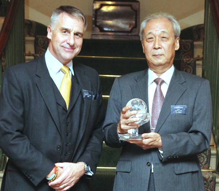
Ian
Moncrieff (UKHO) presents the Alexander Dalrymple award to Dr Hideo
Nishida (JHOD)
OCTOBER
2012
The United Kingdom Hydrographic Office (UKHO) has awarded its Alexander Dalrymple award to Dr Hideo Nishida of the Japan Hydrographic Association.
Dr Nishida was given the award for his contribution to hydrography throughout his lengthy career with the Japan Coastguard, the Japan International Cooperation Agency and the
Japan Hydrographic and Oceanographic Department
(JHOD).
Ian Moncrieff CBE, UKHO chief executive said, “He holds immense respect amongst the international hydrographic community well beyond his own region in which he is equally a legendary figure. It is for his very significant and long standing contribution in capacity building and his high order leadership in response to natural disaster that he is presented with the 2012 Alexander Dalrymple Award.”
The award also recognises his actions taken following the earthquake and
tsunami that hit Japan in 2011. Under his leadership, the JHOD team responded professionally and quickly to the disaster, which played a vital role in Japan’s successful recovery. His work demonstrated the significant role that hydrographic surveys and charting can play in such disastrous situations.
As well as this, Dr Nishida was awarded for his Japan Capacity Building Project, a collaboration set up to annually train six cartographers to the highest international standard.
UKHO
HISTORY
The Admiralty's first Hydrographer was Alexander Dalrymple, appointed in 1795 on the order of King George III and in the next year the existing charts were brought together and catalogued. The first chart the Admiralty produced (of Quiberon Bay in Brittany) did not appear until 1800.
Dalrymple was succeeded on his death in 1808 by Captain Thomas Hurd, under whose stewardship the department was given permission to sell charts to the public. Hurd oversaw the first production of "Sailing Directions" in 1829 and the first catalogue in 1825 with 736 charts. Rear-Admiral Sir W. Edward Parry was appointed Hydrographer in 1823 after his second expedition to discover a Northwest Passage. In 1829, at the age of 55, Rear-Admiral Sir Francis Beaufort became Hydrographer. During this time, he developed his eponymous Scale and saw the introduction of official tide tables in 1833 and the first "Notices to Mariners" in 1834. By the time of Beaufort's retirement in 1855, the Chart Catalogue listed 1,981 charts and 64,000 copies of them had been issued to the Royal Navy.
In the 1930s the collection of oceanographic and naval meteorological data started. At the start of the Second World War chart printing moved to Taunton but the main office did not move until 1968. Metrication of charts began in 1967 while digitisation started in the 1980s. "Admiralty Raster Chart Service" began to be produced in 1996 and in 2000 online services were started. In April 2008 the UKHO launched its AVCS (Admiralty Vector Chart Service) which aims to get round the inability of many smaller hydrographic offices to produce electronic charts by incorporating them into the Admiralty service.
Originally data was mainly collected using ordinary Royal Navy ships. In 1953, the first purpose-built survey vessel was launched; HMS Vidal. The current ships form the "Hydrographic Squadron". The use of the echo sounder and other electronic equipment in the 20th century saw a big increase in the quantity and quality of the data collected.
Under the Public Records Act 1958, UKHO became an authorised 'place of deposit' which has given it the responsibility of maintaining its own archive. Its documents date from 1755. Its prime customer is the Royal Navy for which it produces hydrographic, oceanographic and geophysical products and services. The UKHO also produces a range of outputs for the leisure market. It collects tidal information from around the world and publishes the "Admiralty Tide Tables" (in 4 volumes) and provides an online service called
"Easytide".
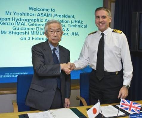
President
JHA Yoshinori Asami and UKHO Chief Executive Ian Moncrieff
JHA
JAPAN UKHO AGREEMENT 2009
Greater flexibility has been granted to mariners transiting through the Malacca and Singapore Straits (MSS) in the United Kingdom Hydrographic Office’s (UKHO) new licensing agreement with the Japan Hydrographic Association (JHA) in a bid to promote comprehensive and safe global ENC (Electronic Navigational Chart) coverage.
Currently licensed to distribute fully comprehensive and detailed ENC’s of the Straits through its Admiralty Vector Chart Service (AVCS), the UKHO’s new agreement allows access to individual ENC’s for periods of six or 12 months, providing greater efficiency in matching ENC coverage to operational patterns for a sustained period of time.
Rear Admiral Ian Moncrieff, UK National Hydrographer of the UKHO, said: “This extension to our existing Bilateral Arrangement with Japan Hydrographic Association underlines the spirit of co-operation between hydrographic offices in improving our offering to seagoers, and particularly the collective commitment throughout the IHO (International Hydrographic Organisation) to the aim of global ENC coverage.
Mr Shinichi Kikuchi, Head of the International Affairs Office of the JHA, added: “I am delighted to announce this latest amendment to our current partnership which will bring flexible licensing to Mariners transiting through the Straits.”
Given the high volume and diversity of shipping traffic under compulsory IMO navigational chart carriage compliance, JHA official data is a significant component of AVCS coverage in the Far East, and the agreement additionally supports the IHO resolution for the provision of adequate global ENC coverage of the main international shipping routes by 2010.
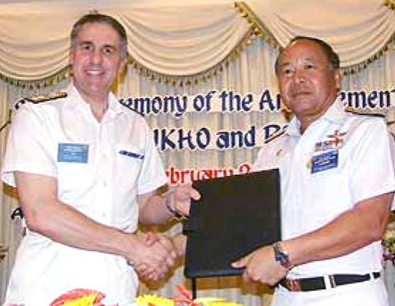
UKHO
Chief Executive Ian
Moncrieff and Vice Admiral Saneh Soontonmongkol, Royal Thai Navy
ROYAL
THAI NAVY and NIOHC CONFERENCE 2007
Rear Admiral Ian Moncrieff, representative of the Hydrographic Department of the UK, and Vice Admiral Saneh Soontonmongkol, director general of the Hydrographic Department of the Royal Thai Navy, co-sign an agreement between the two Hydrographic Departments at the 7th conference of the North Indian Ocean Hydrographic Commission (NIOHC) meeting.
Vice Admiral Saneh said that this cooperative agreement between the two countries was to exchange data and navigational maps. The intention is for all members of the International Hydrographic Organization, the countries of which have borders on territorial waters, to create a navigational map that is satisfactory to all and which will act as an international standard.
The production of a standard electronic navigational chart (ENC) would fix the main navigation lines in each of the territorial waters, and create a tsunami-warning grid, added Vice Admiral
Saneh.
The official opening ceremony for the conference took place on February 28, presided over by Admiral Suchart Yanothai, assistant commander-in-chief of the Royal Thai Navy. The conference took place over the period February 27 to March 2.
Apart from the country members (Bangladesh, Egypt,
India, the Union of Myanmar, Sri Lanka, Thailand, and the United Kingdom) and joining country members (France, Pakistan, the Seychelles, and the United States of America), a number of other countries, namely Malaysia, Oman, Saudi Arabia, Sudan, Yemen and Germany, were invited to observe this meeting.
The North Indian Ocean Hydrographic Commission is a regional hydrographic commission under the
International Hydrographic
Organization, established in the year 2000. The NIOHC conference is held every year, with member countries alternating as the host in alphabetical order.
February 27 saw Rear Admiral Ian Moncrieff, representative of the Hydrographic Department of the UK, and Vice Admiral Saneh Soontonmongkol, director general of the Hydrographic Department of the Royal Thai Navy, co-sign an agreement between the two Hydrographic Departments at the 7th conference of the North Indian Ocean Hydrographic Commission (NIOHC) meeting, which was hosted by the Royal Thai Navy and staged at the A-One Royal Cruise Pattaya Hotel.
IAN
MONCRIEFF CBE - CHIEF EXECUTIVE
Ian Moncrieff (59) was born in Lancashire and graduated in Geography and Geology at Keele University in 1977 on a RN university cadetship. He subsequently enjoyed a varied and always stimulating 34 year career in the Royal Navy.
Qualified as a Principal Warfare Officer (PWO) originally specialising in Communications, he has 20 years operational seagoing experience in 11 warships and embracing 4 Command appointments.
He commanded the destroyer HMS NOTTINGHAM and Antarctic patrol ship HMS ENDURANCE and was the Executive Officer of the aircraft carrier HMS INVINCIBLE. His active service includes OPERATION SHARP GUARD (Former Republic of Yugoslavia) and OPERATION BOLTON (Iraq). He has also held Joint Operational Command as Commander British Forces South Atlantic based in the Falklands.
His staff experience ashore includes a strong pedigree of senior appointments in Policy, Plans and Programmes in MOD Centre, as well as Fleet and Royal Marines HQs. He is a graduate of the Higher Command and Staff Course and Defence Strategic Leadership Course. He holds the IoD certificate in Company Direction.
In
2010 Rear Admiral Ian Moncrieff BA, then 55, was appointed a CBE in the Queen's Birthday Honours for his work as a UK National Hydrographer.
His citation reads: "Establishing this prominent national role at a most testing time for the Hydrographic Office in Taunton, you rose to every challenge. Using exceptional diplomatic skills, you secured the support of the International Hydrographic Organisation and foreign government hydrographic offices; essential to ensure the provision of quality assured digital navigational charts to the Royal Navy and the continued operation of the Hydrographic Office as a viable Trading Fund within the Ministry of Defence...throughout a formidable series of bilateral negotiations you demonstrated unlimited enthusiasm and energy and used your wide sea-going experience to fine effect in identifying innovative and pragmatic solutions. A persuasive ambassador for the United Kingdom and Royal Navy, your remarkable accomplishments are of true national benefit."
In
2009 the then Rear Admiral is quoted as saying this about ECDIS: “There are companies that remain to be convinced but some high quality companies are already a long way down the path to adoption ahead of the regulatory horizon,” he said. Quality issues were not limited to electronic charts and there is a need to look again at paper to make sure problems are not replicated.
The UKHO deputy chief executive accepted that some frustrations of ENC users were well-founded but said the misconceptions were not limited to chart data and usage. “There is a perception that using ENCs are expensive but there is evidence that shipping companies using ECDIS are already saving money. Using flexible licensing arrangements can have a dramatic effect on costs”.
REAR
ADMIRAL TOM KARSTEN - UK NATIONAL HYDROGRAPHER
Tom Karsten was born in 1961 and joined the Royal Navy in 1979. Following training at Britannia Royal Naval College Dartmouth and an in-service degree in History from Exeter University, he embarked on his seagoing career qualifying as a Principal Warfare Officer in 1987.
After a range of warfare appointments, including serving as Naval Assistant to the Commander-in-Chief Fleet during the First Gulf War, he took command of his first ship, the Hunt class mine hunter HMS BICESTER (1993-94). Subsequent promotion led to command of the Type 22 frigate HMS SHEFFIELD (1995-96) for operations in the Far East, Gulf and Mediterranean.
In 1996 he graduated from the Joint Service Defence College and went on to serve in Navy Plans in the MOD during the Strategic Defence Review. After a tour as Staff Operations Officer to the Surface Flotilla he was promoted to Captain in 2001 and appointed first to HQ Royal Marines as the Chief Staff Officer for Plans and Programmes and then to the Fleet HQ as head of the Commitments Division. In 2003, he took command of HMS ENDURANCE (2003-05) for two Antarctic seasons.
Returning ashore in 2005, he spent two years as Director of the Maritime Warfare Centre and, in 2007, was promoted to Commodore serving as Navy Command’s Deputy Commander Operations. This was followed by a year at Oxford University as the Royal Navy’s Senior Hudson Fellow researching Arctic geopolitics. On completion he was appointed as Commander British Forces Gibraltar in September 2010, serving on the Rock for two years.
MIKE
ROBINSON
In October 2011 the UKHO announced that Mike Robinson is stepping down from his role as Chief Executive following five successful years at the head of the organisation. Ian Moncrieff, currently Chief Operating Officer and former UK National Hydrographer, will assume the role of Chief Executive with immediate effect.
In his five years at the head of the UKHO, Mike Robinson has maintained the organisation’s relentless commitment to serving the professional mariner and equipped the industry with a new generation of navigational services to meet mandatory carriage of ECDIS and beyond.
“Mike has been the driving force behind the business for the past five years” says Sandra Rogers, Non-Executive Chair, UKHO. “His energy, passion and vision have delivered a long list of milestone achievements including the Admiralty Vector Chart Service (AVCS) in 2008, which provided the first global, carriage compliant ENC service and the Admiralty Information Overlay, which gives AVCS customers access to previously unavailable, additional information to make passage planning with ENCs even safer and more efficient.
“Throughout his time, Mike has ensured that the UKHO has remained at the forefront of maritime navigation. For example e-Navigator is fundamentally transforming the way that digital charts are selected, purchased and updated and we now provide our customers worldwide with round-the-clock customer service and technical support.”
“Mike leaves the UKHO with a clear vision and a growing range of products and services on which we will continue to build. We wish him every success in the future.” Ian Moncrieff
was appointed interim Chief Executive by the MOD Owners Council and the UKHO Board to ensure a smooth transition and continuing success in the year ahead.
UKHO's
Somerset Archives
UKHO
PUBLICATIONS
Most UKHO publications are available in both paper and online versions. Publications include charts, nautical publications and astronomical publications. Notable nautical publications include Admiralty Sailing Directions (Pilots, 74 volumes), Admiralty Tide Tables (4 volumes), Admiralty List of Radio Signals (6 volumes), Admiralty List of Lights and Fog Signals (10 volumes) and more. Notable astronomical publications include The Nautical Almanac and The Astronomical Almanac among others.
The UKHO archive contains a unique record of the exploration of the maritime world including original manuscripts and early charts by Captain
James Cook and Captain
William Bligh.

UKHO
proposed development
ARCHIVES
The UKHO Archive started life as an accumulation of charts, surveys, reports, books and atlases held within the Admiralty in London. When the Hydrographic Office was established in 1795 the first Hydrographer to the Admiralty Board, Alexander Dalrymple FRS, was charged with arranging and digesting a ‘considerable mass of information’ and was given a clerk to take ‘care of the plans and charts’ that had accumulated in the Admiralty over nearly two centuries. With the expansion in surveying capability after 1815 the number of surveys and, subsequently, printed charts in the Hydrographic Office expanded.
Document accumulation forced the Archive to be moved in 1923 from the Admiralty to Cornwall House. In September 1939, as part of the relocation of Admiralty staff out of London, the Archive, along with the Compilation staff, were moved to the Royal School in Bath.
In October 1941 concerns as to storage conditions at the Royal School
saw the Archive move once again to the outskirts of Bath at Ensleigh.
After the war the Archive was moved for the third time in eight years
back to London in October 1946, not to the Admiralty but to the basement of a building in Cricklewood. The Hydrographer, Sir John Edgell, wanted all his staff to work on one site at Taunton but the Admiralty
held sway until 1964 when the Archive and all the staff were co-located in Somerset. In 2003 a new purpose-built archive was opened by His Royal Highness the Duke of York and named after Rear Admiral G. Steve Ritchie, who had served as Hydrographer of the Navy from 1966 to 1971.
The current Archive holds over 600,000 surveys, books, charts and files, containing millions of individual letters, reports, photographs and documents. Currently the Archive is undertaking a project to transfer its historical material to The National Archives based at Kew, which involves cataloguing over 250 metres of departmental documents dating from the early 1800s.
It is estimated that this will take three years and will improve access to an important collection of historical naval and hydrographic information.
AWW was appointed to undertake the masterplanning, strategic and detailed design proposals for a new headquarters office building, relocation of 100,000sqft printworks/distribution building along with the masterplanning of surplus land for 250 dwellings.
Following this, AWW was commissioned to undertake a refurbishment of the UKHO offices and production facility in 5 phases. The headquarters office building of approximately 160,000sqft reflects the ethos of the organisation whilst incorporating the strict security requirements of the MOD.
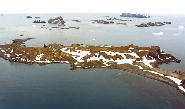
Antarctica:
Aitcho Islands - Cricklewood Island
AUGUST
2013 ANTARCTICA
The UKHO welcomed the honour of having islands named after important historical places and figures in its history, the
IMO Secretary-General is sailing through the Arctic and the location of ships all over the world are being pinpointed.
Among the few spots on the globe that remain resolutely British pink, a small island on the edge of Antarctica has been named in honour of the London suburb of
Cricklewood.
In defiance of Argentine objections to the renaming of the British Antarctic Territory, six of the dots that make up the Aitcho Islands have been given new names. Five are associated with the United Kingdom Hydrographic Office, an agency of the Ministry of Defence.
According to The Times
Cricklewood Island is named after the home of the UKHO’s headquarters in North West London until 1986. Bath Island is named after the agency’s temporary home when it was evacuated during the Second World War and Taunton after the home of its current headquarters in Somerset. Lambert Island is a tribute to Rear-Admiral Nick Lambert, the former National Hydrographer, for his service as commanding officer of the Royal Navy survey vessel HMS Endurance. Gorziglia Island is named after Captain Hugo Gorziglia, the former chairman of the International Hydrographic Organisation’s Commission on Antarctica.
Last year the
IHO approved the production of a large-scale international chart of the Aitcho Islands to improve navigation of the area, which is frequently visited by tourist vessels. Willett Island is named after Andy Willett, the UKHO Geographic Manager who has worked for the agency for 35 years. He said that he was “humbled” by the honour. The new names have been approved by the UK Antarctic Place-names Committee, which considers proposals for features such as mountains, islands and peninsulas within Britain’s possessions around the South Pole.
ACCESS TO DATA & FREEDOM of INFORMATION
As with the Ordnance Survey for land mapping, the Hydrographic Office possesses a government monopoly on data for nautical charts and publications in the
UK. The profitable commercial trading in this fashion is at odds with
free enterprise and the monopolies act. It's a bit like the BBC
television license, when most people would rather not watch BBC channels
and so not have to pay for using the airwaves on other stations which
are free. This is a potential breach of Article 10, which is the right
to receive and impart information. There are no conditions attaching to
a right, otherwise it is no longer a right; surely a subject for
the Monopolies Commission. Or, maybe electronic maps could be obtained
via the IHO, or any IHO
member state supplying information on more user friendly terms - in the
interests of promoting safer
seas.
Ignoring
for now its Ministry of Defence links, the UKHO is supposed to be totally self-funding from the commercial sale of its data and derived products - whilst at the same time it is supposed to be the public supplier of information. In 2010/11 it made a profit of almost £22 million from its commercial activities. These issues are very different to those of the Ordnance Survey where data is gathered at public expense. The UKHO sources much of its information from foreign governments to whom it pays a royalty fee and thus is no burden on the UK taxpayer.
The UKHO has a complex set of licences, according to the use of the product and its value. Whilst it generally allows use for non-navigational purposes at little or no cost, where licencing is for use in a navigational product (which can obviously compete with its core commercial activities), a higher licence fee is charged. Furthermore there are some data sets that it uses in its own products that it refuses to make available to other organisations.
In the Information Fair Trader Scheme Report on the UKHO in April 2011 it states that the UKHO data will not be included in the Public Data Corporation to make government owned data more freely available (part 3, item 29), but it does recommend that the UKHO implements a "Free Navigational Licence" (part 3, item 37).
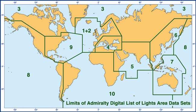
UKHO:
Example of map identifying listing areas
CONTACTS
The United Kingdom Hydrographic Office.
Admiralty Way
Taunton Somerset
TA1 2DN United Kingdom
Telephone:
+44 (0) 1823 723366(24 hour)
Fax: +44 (0) 1823 251816
Telephone: +44 (0) 1823 337900
Fax: + 44 (0) 1823 330 561
Email: customerservices@ukho.gov.uk
Email: recruitment@ukho.gov.uk
Radio Navigational Warnings
Telephone: +44 (0)1823 353448 (direct line)
Fax: +44 (0)1823 322352
Email: navwarnings@btconnect.com
Website:
http://www.ukho.gov.uk
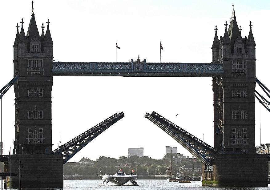
The
UK does not own or operate any zero pollution oceanographic vessels. The
Swiss are therefore significantly advanced and leading the world by
example. Geneva
University is working with the PlanetSolar vessel to monitor the
Gulf Stream. Other expeditions are planned, the next to Rio
de Janeiro to monitor the effect of Saharan dust on the
oceans.
LINKS

http://aww-uk.com/case-study/ukho/ ukho-extends-its-hand-toward-the-japan-hydrographic-association
http://www.maritimejournal.com/news101/industry-news/ukho-appoints-new-national-hydrographer http://en.wikipedia.org/wiki/United_Kingdom_Hydrographic_Office http://www.ths.org.uk http://www.spri.cam.ac.uk/friends/committee/ http://www.thefutureofnavigation.com/ten_steps.aspx http://www.quaynote.com/ankiti/www/?code=ecdis13&f=programme
Wiki
United_Kingdom_Hydrographic_Office
http://www.linkedin.com/pub/ian-moncrieff/13/226/54b http://www.admiralty.co.uk/Pages/Senior-Staff-Biographies.aspx http://www.ths.org.uk/news_details.asp?v0=394 http://iec09live.wordpress.com/page/2/ http://subseaworldnews.com/2011/10/19/ukho-chief-executive-mike-robinson-to-step-down-uk/ http://www.maritimejournal.com/news101/industry-news/ukho-award-recognises-hydrographic-contribution
http://www.pattayamail.com/710/news.shtml
http://blog.admiralty.co.uk/tag/ukho/
http://www.iho.int/srv1/ http://www.iho.int/srv1/index.php?option=com_content&view=article&id=432&Itemid=391
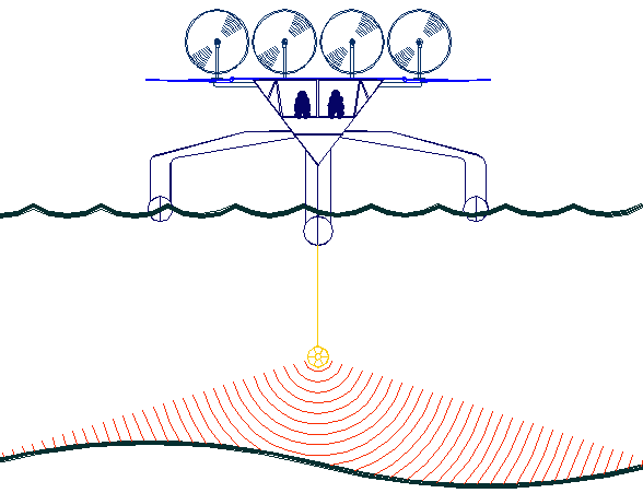
The
key to accurate hydrographic mapping is continuous monitoring,
for which the SNAV
platform, presently under development, is a robotic ocean workhorse with a
maximun speed of 18 knots. Based on a stable
SWASH
hull this design is under development in the United Kingdom. This robot
ship will use no diesel fuel to monitor the oceans autonomously (COLREGS
compliant) at relatively high
speeds of between 7-10 knots, 24/7 and 365 days a year - only possible with the revolutionary (patent) energy harvesting system. The
Bluefish hullform is ideal for automatic release and recovery of ROVs
or towed arrays, alternating between drone and fully autonomous modes.
International development partners are welcome. This vessel
pays for itself in fuel saved every ten years.
|