|
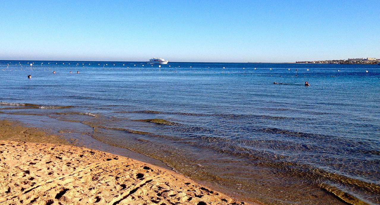
Red
Sea, Makadi Bay
The Red Sea is a seawater inlet of the Indian Ocean, lying between Africa and Asia. Its connection to the ocean is in the south, through the Bab el Mandeb strait and the Gulf of Aden. To its north lie the Sinai Peninsula, the Gulf of Aqaba, and the Gulf of Suez (leading to the Suez Canal). It is underlain by the Red Sea Rift, which is part of the Great Rift Valley.
The Red Sea has a surface area of roughly 438,000 km2 (169,100 mi2), is about 2250 km (1398 mi) long, and — at its widest point — 355 km (220.6 mi) wide. It has an average depth of 490 m (1,608 ft), and in the central Suakin Trough it reaches its maximum depth of 3,040 m (9,970 ft).
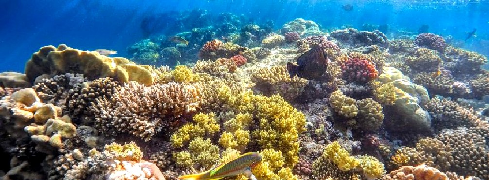
The Red Sea also has extensive shallow shelves, noted for their marine life and
corals. The sea is the habitat of over 1,000 invertebrate species and 200 types of soft and hard coral. It is the world's northernmost tropical sea, and has been designated a Global 200 ecoregion.
OCEANOGRAPHY
The Red Sea is between arid land, desert and semi-desert. Reef systems are better developed along the Red Sea mainly because of its greater depths and an efficient water circulation pattern. The Red Sea water mass-exchanges its water with the Arabian Sea, Indian Ocean via the Gulf of Aden. These physical factors reduce the effect of high salinity caused by evaporation in the north and relatively hot water in the south.
The climate of the Red Sea is the result of two monsoon seasons; a northeasterly monsoon and a southwesterly monsoon. Monsoon winds occur because of differential heating between the land and the sea. Very high surface temperatures and high salinities make this one of the warmest and saltiest bodies of seawater in the world. The average surface water temperature of the Red Sea during the summer is about 26 °C (79 °F) in the north and 30 °C (86 °F) in the south, with only about 2 °C (3.6 °F) variation during the winter months. The overall average water temperature is 22 °C (72 °F). Temperature and visibility remain good to around 200 m (656 ft). The sea is known for its strong winds and unpredictable local currents.
The rainfall over the Red Sea and its coasts is extremely low, averaging 0.06 m (2.36 in) per year. The rain is mostly short showers, often with thunderstorms and occasionally with dust storms. The scarcity of rainfall and no major source of fresh water to the Red Sea result in excess evaporation as high as 205 cm (81 in) per year and high salinity with minimal seasonal variation. A recent underwater expedition to the Red Sea offshore from Sudan and Eritrea found surface water temperatures 28 °C (82 °F) in winter and up to 34 °C (93 °F) in the summer, but despite that extreme heat, the coral was healthy with much fish life with very little sign of coral bleaching, with only 9% infected by Thalassomonas loyana, the 'white plague' agent. Favia favus coral there harbours a virus, BA3, which kills T. loyana. Plans are afoot to use samples of these corals' apparently heat-adapted commensal algae to salvage bleached coral elsewhere.
ECOSYSTEM
The Red Sea is a rich and diverse ecosystem. More than 1200 species of fish have been recorded in the Red Sea, and around 10% of these are found nowhere else. This also includes 42 species of deepwater fish.
The rich diversity is in part due to the 2,000 km (1,240 mi) of coral reef extending along its coastline; these fringing reefs are 5000–7000 years old and are largely formed of stony acropora and porites corals. The reefs form platforms and sometimes lagoons along the coast and occasional other features such as cylinders (such as the Blue Hole (Red Sea) at Dahab). These coastal reefs are also visited by pelagic species of Red Sea fish, including some of the 44 species of
shark.
It contains 175 species of nudibranch, many of which are only found in the Red Sea.
The Red Sea also contains many offshore reefs including several true atolls. Many of the unusual offshore reef formations defy classic (i.e., Darwinian) coral reef classification schemes, and are generally attributed to the high levels of tectonic activity that characterize the area.
The special biodiversity of the area is recognized by the Egyptian government, who set up the Ras Mohammed National Park in 1983. The rules and regulations governing this area protect local marine life, which has become a major draw for diving enthusiasts.
Divers and snorkellers should be aware that although most Red Sea species are innocuous, a few are hazardous to humans: see Red Sea species hazardous to humans.
Other marine habitats include sea grass beds, salt pans, mangroves and salt marshes.
POLLUTION
There is extensive demand for desalinated water to meet the needs of the population and the industries along the Red Sea.
There are at least 18 desalination plants along the Red Sea coast of Saudi Arabia which discharge warm brine and treatment chemicals (chlorine and anti-scalants) that bleach and kill corals and cause diseases in the fish. This is only localized, but it may intensify with time and profoundly impact the fishing industry.
The water from the Red Sea is also used by oil refineries and cement factories for cooling.
PLASTIC BAN MARCH 2019
Egypt’s Red Sea governorate has decided to ban single-use bags and all disposable plastics, starting from June, turning it into a “Go Green” land. Governor Ahmed Abdallah’s main goal is to protect wildlife, marine life, and endangered species, all of which have been harmed and negatively affected by plastic.
The Association for The Protection of the Environment (A.P.E.) has taken action against
plastic as it also affects human health. The decree will ban the use of plastic bags in food shops, restaurants, supermarkets, grocery stores and pharmacies. Plastic knives and forks, cups, and straws will also be banned in restaurants and on cruise ships within the governorate; however, heavy duty garbage collection bags are not included in the ban.
The Red Sea governorate will not give authorisation for the production of plastic bags within the area. Back in 2017, The Egyptian Ministry of Environment launched an EU-funded initiative called “Enough Plastic Bags” which aims to eliminate the country’s dependency on plastic bags, due to their negative effects on the environment and the
blue
economy.
Additionally, the Hurghada Environmental Protection and Conservation Association (HEPCA) will launch an awareness campaign about negative impacts concerning plastic on marine life and
human
health. The campaign will include on-ground activation, with events, and also public figures who will give lectures to public and private
schools. HEPCA will also have clean-up teams for islands, beaches, and underwater in collaboration with schools, diving centres, and the Red Sea community.
The main goal of this campaign is to encourage people to go environmental friendly and reduce their consumption of
plastic bags as they should always be aware of the actions they take cornering the ecosystem.
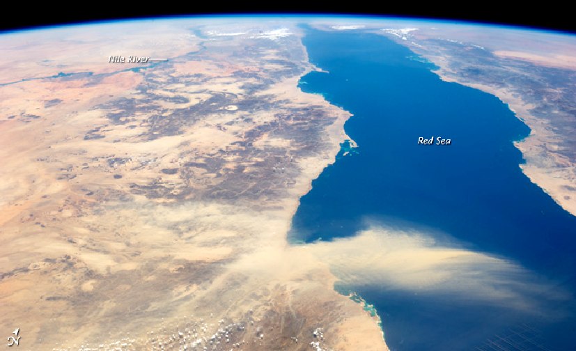
NASA satellite
photo, dust storm across the Red Sea.
HISTORY
The earliest known exploration of the Red Sea was conducted by ancient Egyptians, as they attempted to establish commercial routes to Punt. One such expedition took place around 2500 BC, and another around 1500 BC (by Hatshepsut). Both involved long voyages down the Red Sea. The biblical Book of Exodus tells the account of the Israelites' crossing of a body of water, which the Hebrew text calls Yam Suph (Hebrew: יַם סוּף). Yam Suph was traditionally identified as the Red Sea. Rabbi Saadia Gaon (882‒942), in his Judeo-Arabic translation of the Pentateuch, identifies the crossing place of the Red Sea as Baḥar al-Qulzum, meaning the Gulf of Suez.
In the 6th century BC, Darius the Great of Persia sent reconnaissance missions to the Red Sea, improving and extending navigation by locating many hazardous rocks and currents. A canal was built between the Nile and the northern end of the Red Sea at Suez. In the late 4th century BC, Alexander the Great sent Greek naval expeditions down the Red Sea to the Indian Ocean. Greek navigators continued to explore and compile data on the Red Sea. Agatharchides collected information about the sea in the 2nd century BC. The Periplus of the Erythraean Sea ("Periplus of the Red Sea"), a Greek periplus written by an unknown author around the 1st century, contains a detailed description of the Red Sea's ports and sea routes. The Periplus also describes how Hippalus first discovered the direct route from the Red Sea to India.
The Red Sea was favored for Roman trade with India starting with the reign of Augustus, when the Roman Empire gained control over the Mediterranean, Egypt, and the northern Red Sea. The route had been used by previous states but grew in the volume of traffic under the Romans. From Indian ports goods from China were introduced to the Roman world. Contact between Rome and China depended on the Red Sea, but the route was broken by the Aksumite Empire around the 3rd century AD.
Middle Ages and modern era
During the Middle Ages, the Red Sea was an important part of the spice trade route. In 1183, Raynald of Châtillon launched a raid down the Red Sea to attack the Muslim pilgrim convoys to Mecca. The possibility that Raynald's fleet might sack the holy cities of Mecca and Medina caused fury throughout the Muslim world. However, it appears that Reynald's target were the lightly armed Muslim pilgrim convoys rather the well guarded cities of Mecca and Medina, and the belief in the Muslim world that Reynald was seeking to sack the holy cities was due to the proximity of those cities to the areas that Raynald raided. In 1513, trying to secure that channel to Portugal, Afonso de Albuquerque laid siege to Aden but was forced to retreat. They cruised the Red Sea inside the Bab al-Mandab, as the first fleet from Europe in modern times to have sailed these waters.
Later in 1524 the city was delivered to Governor Heitor da Silveira as an agreement for protection from the Ottomans. In 1798, France ordered General Napoleon to invade Egypt and take control of the Red Sea. Although he failed in his mission, the engineer Jean-Baptiste Lepère, who took part in it, revitalised the plan for a canal which had been envisaged during the reign of the Pharaohs. Several canals were built in ancient times from the Nile to the Red Sea along or near the line of the present Sweet Water Canal, but none lasted for long. The Suez Canal was opened in November 1869. After the Second World War, the Americans and Soviets exerted their influence whilst the volume of oil tanker traffic intensified. However, the Six-Day War culminated in the closure of the Suez Canal from 1967 to 1975. Today, in spite of patrols by the major maritime fleets in the waters of the Red Sea, the Suez Canal has never recovered its supremacy over the Cape route, which is believed to be less vulnerable to
piracy.
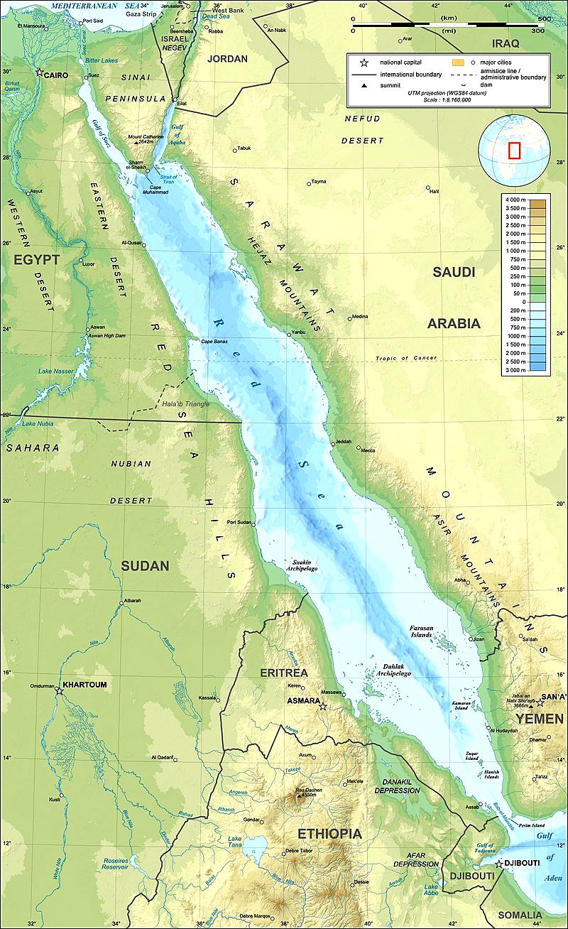
Topographical
map of the Red Sea area
GEOLOGY
The Red Sea was formed by the Arabian peninsula being split from the Horn of Africa by movement of the Red Sea Rift. This split started in the Eocene and accelerated during the Oligocene. The sea is still widening (in 2005, following a three-week period of tectonic activity it had grown by 8m), and it is considered that it will become an ocean in time (as proposed in the model of John Tuzo Wilson). In 1949, a deep
water survey reported anomalously hot brines in the central portion of the Red Sea. Later work in the 1960s confirmed the presence of hot, 60 °C (140 °F), saline brines and associated metalliferous muds. The hot solutions were emanating from an active subseafloor rift. Lake Asal in Djibouti is eligible as an experimental site to study the evolution of the deep hot brines of the Red Sea. Indeed, by observing the strontium isotope composition of the Red Sea brines, it is easy to deduce how these salt waters found at the bottom of the Red Sea could have evolved in a similar way to Lake Asal, which ideally represents their compositional extreme. The high salinity of the waters was not hospitable to living organisms.
Sometime during the Tertiary period, the Bab el Mandeb closed and the Red Sea evaporated to an empty hot dry salt-floored sink. Effects causing this would have been:
- A "race" between the Red Sea widening and Perim Island erupting filling the Bab el Mandeb with lava.
- The lowering of world sea level during the Ice Ages because of much water being locked up in the ice caps.
A number of volcanic islands rise from the center of the sea. Most are dormant. However, in 2007, Jabal al-Tair island in the Bab el Mandeb strait erupted violently. Two new islands were formed in 2011 and 2013 in the Zubair Archipelago, a small chain of islands owned by Yemen. The first island, Sholan Island, emerged in an eruption in December 2011, the second island, Jadid, emerged in September 2013.
TOURISM
The sea is known for its recreational diving sites, such as Ras Mohammed, SS Thistlegorm (shipwreck), Elphinstone Reef, The Brothers, Daedalus Reef, St.John's Reef, Rocky Island in Egypt and less known sites in Sudan such as Sanganeb, Abington, Angarosh and Shaab Rumi.
The Red Sea became a popular destination for diving after the expeditions of Hans Hass in the 1950s, and later by Jacques-Yves Cousteau. Popular tourist resorts include El Gouna, Hurghada, Safaga, Marsa Alam, on the west shore of the Red Sea, and Sharm-el-Sheikh, Dahab, and Taba on the Egyptian side of Sinaï, as well as Aqaba in Jordan and Eilat in Israel in an area known as the Red Sea Riviera.
The popular tourist beach of Sharm el-Sheikh was closed to all swimming in December 2010 due to several serious shark attacks, including a fatality. As of December 2010, scientists are investigating the attacks and have identified, but not verified, several possible causes including over-fishing which causes large sharks to hunt closer to shore, tourist boat operators who chum offshore for
shark-photo opportunities, and reports of ships throwing dead livestock overboard. The sea's narrowness, significant depth, and sharp drop-offs, all combine to form a geography where large deep-water sharks can roam in hundreds of meters of water, yet be within a hundred meters of swimming areas. The Red Sea Project is building highest quality accommodation and a wide range of facilities on the coast line in Saudi Arabia. This will allow people to visit the coastline of the Red Sea by the end of 2022 but will be fully finished by 2030.
OIL
The Durwara 2 Field was discovered in 1963, while the Suakin 1 Field and the Bashayer 1A Field were discovered in 1976, on the Egyptian side of the Red Sea. The Barqan Field was discovered in 1969, and the Midyan Field in 1992, both within the Midyan Basin on the Saudi Arabian side of the Red Sea. The 20-m thick Middle Miocene Maqna Formation is an oil source rock in the basin.
Oil seeps occur near the Farasan Islands, the Dahlak Archipelago, along the coast of Eritrea, and in the southeastern Red Sea along the coasts of Saudi Arabia and Yemen.
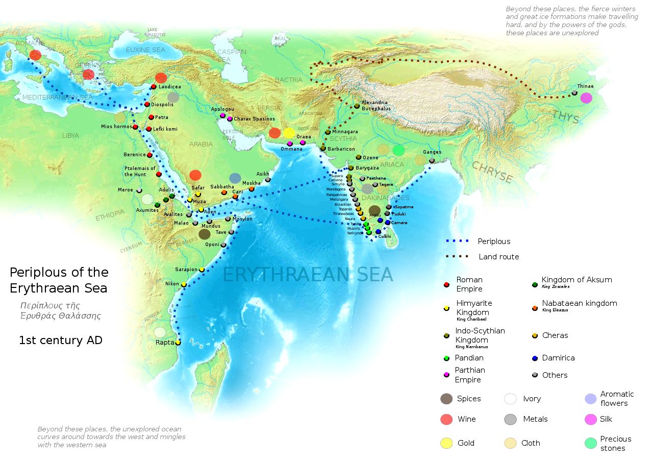
Map
of the Periplous of the Erythraean Sea
ACIDIFICATION
- ADRIATIC - ARCTIC
- ATLANTIC - BALTIC
- BAY BENGAL - BERING
- CARIBBEAN - CORAL
- EAST CHINA
ENGLISH
CH - GOC
- GULF GUINEA - GULF
MEXICO - INDIAN -
IOC
- IRC
- MEDITERRANEAN - NORTH
SEA - PACIFIC - PERSIAN
GULF - SEA JAPAN
STH
CHINA - PLASTIC
- PLANKTON - PLASTIC
OCEANS - RED
- SEA
- SEA
LEVEL RISE - UNCLOS
- UNEP
WOC
- WWF
AMAZON
- BURIGANGA - CITARUM - CONGO -
CUYAHOGA - GANGES - IRTYSH -
JORDAN - LENA - MANTANZA-RIACHUELO
MARILAO
- MEKONG - MISSISSIPPI - NIGER - NILE - PARANA - PASIG - SARNO - THAMES
- YANGTZE - YAMUNA - YELLOW
LINKS
& REFERENCE
https://www.cairo360.com/article/sights-travel/red-sea-governorate-to-ban-plastic/
|